Saturday, 8 February 2020

Badenoch - A little bit of wildness in my life

There is no real wilderness left in Scotland. The hills may look empty but there are no longer big tracks of land untouched by the hand of man or unaltered by his meddling with nature. Only fragments remain of the Highland pinewoods and the coastal rainforests which have been diminished by the monoculture of grouse moors or overgrazed by sheep and deer. And long gone are the apex predators that stalked those woods. But mankind has not always been in this landscape and one day in the future, will no doubt be absent again, and the wilderness will return. My heart aches though with the knowledge that my own life will have been lived in an era when nature is so diminished. I have to find joy, not in wilderness, but in ‘wildness’ which I think of as small pockets of the land where nature still reigns and the elements feel dominant. Thankfully, there is still a lot of wildness in Scotland. I would even say that in my lifetime, the places of wildness have increased a little, as man’s hand has been turned to good for a change.  

One place where I find wildness is a cluster of small, unassuming hills, tucked away behind Dalwhinnie. The land here, as everywhere, is much altered with woods crippled by overgrazing and now a powerline connecting the grid to a new hydro scheme on the Pattack. But there is nonetheless wildness here that overcomes these negatives, allowing the natural landscape to shine through. I’ve visited these hills twice now, both times in January, so the winter elements and emptiness probably add to the feeling of wildness. The second visit was a little less empty as my friend Graham came along too. 

Not as flashy as their nearby Munro neighbours, these hills are still rugged and shapely and inviting. The walk there is just under one and a half hours from the train station at Dalwhinnie. At first it’s along the road north but it soon turns off onto the old right of way to Feagour. 


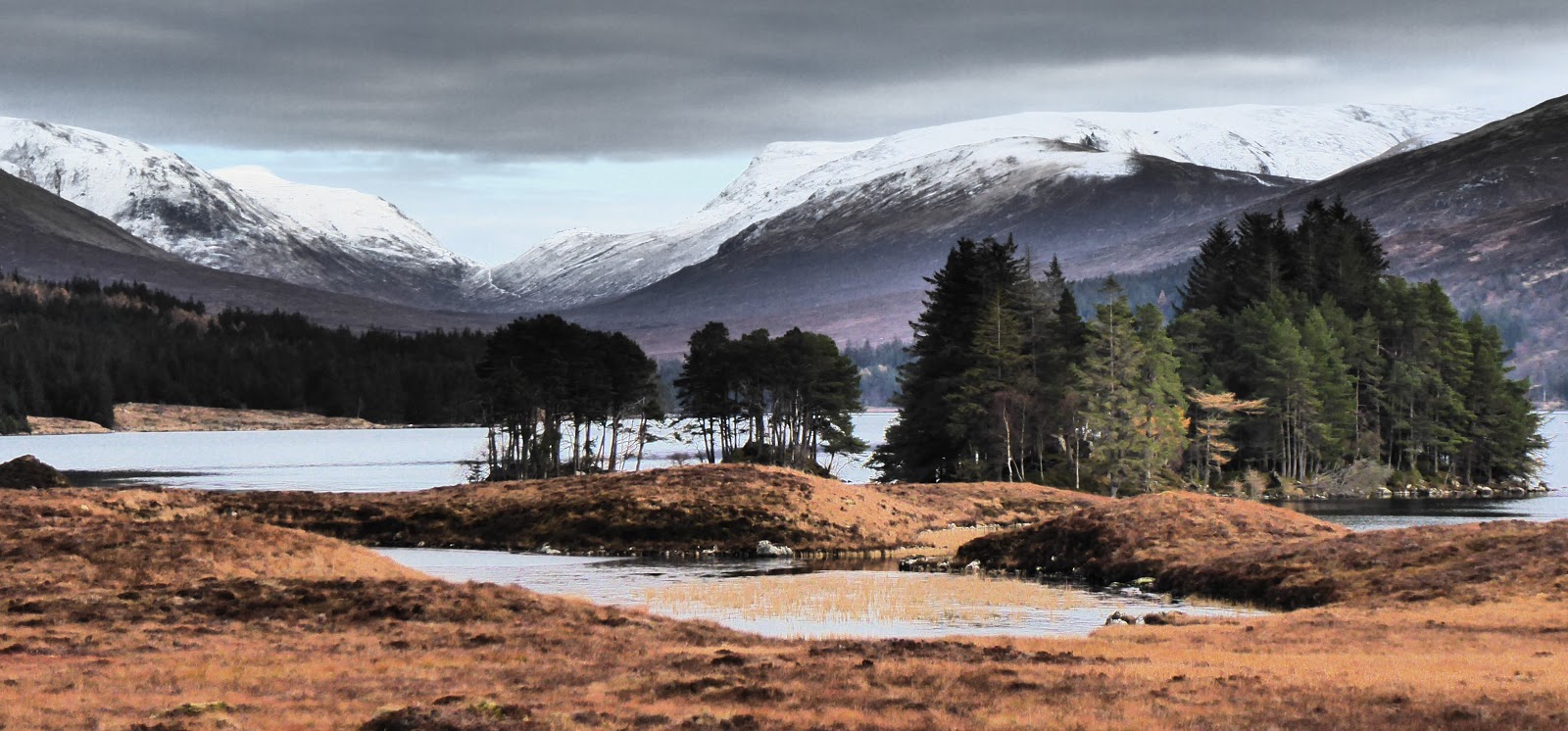
Track and footpath then meander up the glen, switching back and forth on different sides of the river. The view ahead is dominated by the rocky pyramid of the main hill of the group, Meall nan Eagan, and softened by thin birch woods, remnants of a once bigger forest. The weather on my most recent visit was mild and grey, contrasting with my first trip which was gripped in frozen snow and ice, adding to the still, quietness of the place.


Soon the glen opens out to a wide upper valley and the view now extends to the Fara, rising to the east in snow-streaked slopes, and the Dircs, two gigantic, boulder-strewn slashes in the landscape. In my mind, the Dircs are the key factor in the wildness of this place. A throwback to the last Ice Age, they were created thousands of years ago by glacial meltwater. 


When the ground is frozen, there are lots of options for pitching the tent. When it’s not, we are squeezed onto a grassy verge on a bend in the river. The river is narrow at this point but eerily deep, and just upstream it cascades over rocks, filling the place with sound.


My usual walk is an amble up Meall nan Eagan which affords great views despite its lack of height. The Ben Alder Munros stretch out to the south, all bulk and dramatic ridgeline, while the snow-covered plateau of Creag Meagaidh fills the view north.  


I then drop westwards off the top and investigate the lower reaches of the Dirc Mhor and the Dirc Beag. I marvel at the wild secrets hidden in their little-visited boulder fields and inaccessible woods. In the Dirc Beag a stream meanders through a jumble of huge rocks which sprout gnarled trees and colourful mosses. On the grass is scat and the skeleton of a deer that's been separated and dragged about the place. A predator of some sort. Finally I meander back alongside the river and finish the day with a lazy afternoon, relaxing at the tent.


Sitting there sipping tea and enjoying the last remnants of the Christmas cake, I gaze across to the opposite side of the river. There is a fenced area of regenerating woods - another bit of wildness. I dream that in the years to come the trees will break free of the fence that confines them and run rampant across the hills. Then this place will again be wilderness.

Fact File
Start/finish: Dalwhinnie
Public transport: Inverness trains and buses
My route: From the station walked down to the main street, turned left and walked out on the A889. At the top of its steep climb the right of way to Feagour is signed to the left. Pass in front of the cottage and continue up the glen on footpath and track. Meall nan Eagan appears ahead. The east shoulder gives easy access to the top. Dropped off west and followed the Allt an t-Sluic back, giving good views into the Dircs. I walked through the Dirc Mhor a few years ago - it's rough. The Dirc Bheag looks impenetrable. Returned to Dalwhinnie next morning the same way. This makes for good short trip or easy overnighter.

Monday, 27 January 2020

Traprain Law - Treasure

Right in the heart of East Lothian, rising steeply from the rolling farmland around it, is a fascinating lump of volcanic rock called Traprain Law. Like so many of these isolated, small hills, it held great significance for ancient people and has a colourful history. It’s believed that it was occupied as far back as the Bronze Age in 1500BC and it’s known that bronze tools were made here. According to an ancient transcript, King Loth ruled from Traprain Law in 528 and gave his name to the region we know today as Lothian. Around the time of the Roman invasion into Scotland in 80AD, a tribe called the Votadini centred their kingdom around Traprain Law and traded with the Romans until they eventually withdrew south. Nearly 2,000 years later in 1919, archaeologists discovered a hidden treasure of Roman silver on the Law. Weighing in at 24kg, it was the largest hoard ever found of late Roman “hack silver”, meaning that it had been cut up into small pieces. 


My friend Graham and I recently headed out by bike to explore Traprain Law. Our own treasure was a beautiful winter’s day for our trip. We started out by cycling along the Longniddry to Haddington railway path. This is one of my favourite places to cycle. It’s wrapped up in dense hedgerows as it cuts a line across the countryside so that the rest of the world seems far away. Birds flit around the bushes and in autumn it’s a blaze of red from the hawthorn berries. This morning the low winter sun struggled to clear the hedgerows so that the verges were frosted silver and the trees backlit with white gold.


As we cycled over the pretty arches of Nungate Bridge in Haddington, the scene before us was quite beautiful. The old church hugged a bend in the river above which hung a delicate veil of mist. Everything sparkled in a thick layer of frost. Traprain Law had been in our sights as we approached Haddington but as we cycled out the other side of town, it seemed now to mysteriously disappear. A strange trick of the landscape that had me check the map. Eventually it popped up again in front of us and a stiff pull had us at the bottom of the Law’s footpath. We chained up the bikes and started to climb the steep, northern slopes.


The Law is only 221m high so it wasn’t long before we were striding across the flat summit. What a place to be on that clear, crisp day. To the south the Lammermuirs quickly crowded the view while to the west, the Pentland Hills stretched to the horizon. Looking east the land quickly gave way to the blue waters of the North Sea and we could even see the squat shape of the Isle of May. But mostly the eye was drawn north across the Firth of Forth to Fife, dominated by the twin peaks of the Lomond Hills. How marvellous to think that 2,000 years ago King Loth would have stood here and looked across the water to the same view. The hills are so timeless and appear so permanent in our own short lives.

We picnicked behind a boulder, out of the chill wind, then walked down to our bikes to cycle back the way we had come. When we pulled in again to Haddington, the sun had mustered a hint of warmth that had chased away the frost and the mist. We sat outside with coffee and watched the river meander slowly under the bridge, carrying mallards and goosanders downstream as if on an underwater conveyer belt.


By the time we were cycling back along the old railway path, the sun was already low again, bringing back the morning chill and cross-hatching our trail with beams of gold.

Fact File
Start/finish: Longniddry train station
Public transport: Took the folding bikes on the North Berwick train, getting off at Longniddry.
My route: Exited right out of the station and immediately followed signs for NCN76 under the railway. The section to Haddington is traffic free though the surface is soft in places so best for trail/mountain bikes. Continued to follow the NCN signs through Haddington and out the other side. Just over 4km after the outskirts of Haddington, the road splits - the cycle route goes left, but stay right up the hill towards Traprain Law. We used the first access point at the top of the road where an obvious path climbs to the top of the hill. Back the same way.
Info: Waterside Bar beside Nungate Bridge is a nice place to sit by the river with a hot drink.


Saturday, 18 January 2020

Roslin Glen - Gunpowder, season and grot

The name Roslin is probably known to most people because of the famous Rosslyn Chapel but tucked away behind the chapel is a wonderful wooded glen. Combining a walk here with another loop towards Bilston created a great, figure-of-eight walk with Roslin at the centre and lots of interesting sights on the way round. My friend Graham and I headed there for a walk during the festive season.

Once off the bus we headed towards the chapel but turned off just before to head down into the glen by an old lane alongside the cemetery. Mosses and lichens covered the walls and the jaunty-angled gravestones, adding splashes of colour to the plain winter palette. Soon we were in the glen itself, a steep-sided, wooded dip cut out over the millenia by the waters of the River North Esk. Our path meandered upriver, initially high above the water but latterly dropping to be right beside it.


Walking signs had been promising us old gunpowder mills and sure enough, the ruins eventually appeared through the trees. The mills operated between 1803 and 1954, providing gunpowder for military and mining purposes. Incredibly, the company that operated the mills became ICI, the global chemicals giant. The ruins were a real treat because we could still see the building that had housed the waterwheel and the lade that had diverted water from the river to power it. Despite the explosive history of the mills, the ruins were now a peaceful place being gradually reclaimed by nature.


Beyond the mills we joined the old railway line that once ran between Edinburgh and Peebles and has now been repurposed as a walking and cycling route. It took us back in the direction of Roslin. With a bit of zig-zagging we found ourselves back in Roslin Glen where the path passed by Roslin Castle. The castle occupies a high, rocky promontory in the glen which has been the site of a fortification since the early 14th century. We walked across the old arched bridge which gives access to the castle and were amazed to find that not only is a large part of it still habitable but that somebody was even at home!


We returned to the village green for a picnic lunch. It’s always nice being in different places during the festive season to enjoy the variety of Christmas lights and decorations. Roslin Inn, an old coaching inn overlooking the green, is the village’s centrepiece and was adorned with luxurious festive wreaths. 


After lunch, we headed out towards Bilston, passing the memorial to the Battle of Roslin in 1303. It commemorates a Scottish victory in the First War of Scottish Independence. Beyond here the views opened up to the Pentland Hills to the north as we found ourselves on another section of the old railway line. The impressive Bilston Viaduct took our route high above the cut of Bilston Glen before we turned off north. Here we walked through disused railway sidings which had grown up with dense birch over the years. It was a beautiful place and a little bit of wildness tucked away behind the city’s outlying towns.


We looped back to Roslin by passing to the north of Dryden Tower, built as a folly by the owner of Dryden House. It’s a shame we couldn’t go up because the views would have been superb on the crisp, clear day we were there. While the tower still stands tall and handsome, there is nothing left of the house which fell into ruin and was then obliterated by Bilston Colliery. Our walking route here had linked together rural paths and farm tracks that took us across fields and through woods. It was very pleasant but it was also very muddy with that squelchy, claggy mud that clings in great lumps to your boots. So, despite our best efforts to remove the mud with long grass and twigs, by the time we were walking back into Roslin, we were both pretty grotty. We skipped a visit to the tearoom in the interests of not trailing all the mud in!


On the journey home on the bus, I mused on what a fascinating little walk it had been and would definitely recommend it. But if you should do it in winter then ... remember, remember the filth of December ... and take wellies.

Fact File
More photos on Flickr: click HERE
Start/finish: Roslin
Public transport: Lothian Buses no 37 from Edinburgh city centre
My route: Off the bus walked towards the chapel but immediately after the car park on the right, a lane heads downhill to the right. Followed this path until we came to a road, turned left and picked a path again which led onto the mills. At the mills crossed the bridge over the river and over a rise joined the old railway line. Turned left and followed it to the old Rosslyn Castle station. Took a footpath to the left which emerged onto a quiet back road. Turned right then left at the next junction which leads to a path back into the glen. It passed the castle and emerged back at the chapel. For the Bilston loop, we headed east along Manse Road in front of the inn, turned left after the viaduct and then followed footpath signs back to Roslin.

Thursday, 2 January 2020

Perthshire - Obney overnighter

When I got home from a wee trip in the Obney Hills and posted pictures on Facebook, several people commented that they had no idea where the Obney Hills were. And to be honest, if I’d not been staring at them on my Ordnance Survey map for a few weeks, I wouldn’t have known either. A cluster of small but well-defined little hills, they occupy the land to the west of Birnam Hill in Perthshire. On the map their tops of tight contours looked appealing as did an inviting path that cut right though the middle of their rocky outcrops. So, the rucksack was packed and a train ticket to Dunkeld booked.

On a freezing, winter afternoon, I set out from the train station up Birnam Hill. With a heavy winter pack and having climbed it several times before, I’d not planned to walk over Birnam Hill. But a line closure had delayed my train, leaving only three hours of light in the December day. So up and over the hill was the quickest route. It worked out well. The wooded slopes had a smattering of snow illuminated by golden beams from the low afternoon sun. Also, late in the day, I had the whole place to myself.


Once over the top, I left the path and picked my way down the hill through rugged woods and crags. It felt secretive here, as if nobody else had ever walked this way, and the thin covering of snow under the trees was untouched, save for a few animal tracks. This steep-sided descent levelled out at a small bealach before the land crumpled up again to become the Obney Hills. With a bit of hunting around, I found a small stream for water and a slate mound that provided a pitch for the tent. It didn’t hold the tent pegs very tightly though and I hoped the wind wouldn’t get up later. It didn’t and it was a beautiful, calm evening with a golden moon and a scatter of stars.


It was still calm next morning as I unzipped the tent to a couple of inches of fresh snow. I didn’t linger long in my sleeping bag but set off up Craig Obney. It was hard work in deep heather with a covering of snow but my efforts were rewarded as the sun cleared the surrounding hills. The landscape was transformed in the peachy, morning light which picked out the snow-covered tops of the bigger Perthshire hills. Down below, the fields lay under the finest veil of mist. 


I soaked it all in then continued up on a mix of pathless terrain, vague track and finally a firm little path that took me to the top of the hill. The sun had disappeared behind cloud again so the landscape was now monochrome. Piling in from the west was another weather front and no sooner had I taken a couple of snaps at the top, than it was upon me. Big, fluffy flakes of snow engulfed the place and the cloud dropped below the tops of even these small hills. 


I descended to pick up the footpath in Glenn Garr, the place that had looked so inviting on the map. I wasn’t disappointed. The glen that day was a winter wonderland and my own private Narnia. The bare birch trees looked so beautiful dressed in snow as the path, clearly an ancient route, meandered through the winter woods. At one point it was a shelf cut into the steep hillside and looked down on snow-covered pastures where two roe deer bounded across the fields. 


I walked a while south, not with any intent other than to enjoy the place, before turning north again for my onward route. Gradually, I left the winter woods behind as the path entered a patchwork of fields, the snow-covered ground dissected by the black lines of stock walls. It was all so cold and bleak which I love. Crossing a main road pulled me briefly out of my magical, winter world and here were also the first people I’d seen since leaving the station the day before. But the magic quickly returned as I picked up a series of woodland paths by the roaring, peaty waters of the aptly named Rumbling Bridge. 


The trail meandered down through the gorge of the Hermitage, at times clear and earthy where the snow hadn’t penetrated the pine trees but where there were bare, deciduous trees, these and the path were again plastered with snow. My route returned to civilisation at the pretty cottages of Inver. In the half dark afternoon, brightly coloured Christmas lights twinkled where people had hung them along fences or wrapped them around trees. The cosiness and colour were a contrast to the monochrome bleakness of the hills I’d just left.

Fact File
More photos on Flickr - click HERE
Start/finish: Dunkeld and Birnam train station
Public transport: Edinburgh/Glasgow trains to Inverness
My route: Out of the station, turned left at the bottom of the steps. Just after cottages the path up Birnam Hill leaves to the left. Descended a little way on the far side then left the path to descend south. There’s a bealach between Birnam Hill and the Obney Hills which only just worked as a decent camp spot. Next day continued southwest to top of Craig Obney. No path initially then bits of a track and then a good path on the final steep section. Descended northwest to pick up the path through Glen Garr. After a walk through the glen, walked north – track comes out on A822 and immediately opposite is a path through the trees to Rumbling Bridge. So no need to walk on the road. Crossed the bridge then turned right to follow paths through the Hermitage and onto Inver and Dunkeld.

Saturday, 21 December 2019

Corrour - The old favourite

With the first snow on the hills and cheap rail tickets on offer, it was time for an early winter visit to one of my favourite places – Corrour. It’s hard to believe but I’ve been going there for over twenty-five years now. If you don’t know it, it’s a remote stop on the West Highland railway line where it crosses Rannoch Moor. There is no road access, just the train and a number of tracks and trails that radiate out from the station in every direction into wild hill country. 


My friend Graham and I got the morning train and jumped off at Rannoch, the stop before Corrour. Over a few hours we walked north towards Corrour on the old Road to the Isles. It’s a rugged track that passes high above the moor on the flank of Carn Dearg and it was wonderful walking there that day. The low winter sun created a beautiful, soft light that picked out the snow-covered hills all around us and illuminated the russets of the spent summer grasses. 


Because the track is so high, it affords a wonderful, airy view over a landscape of moor and mountain. Our panorama stretched from the Bridge of Orchy hills, over the Black Mount to Glen Coe and then west to the Mamores and Ben Nevis. Scotland is at its most stunning in winter light and a dusting of snow. It looks so much more elemental and I love the elements, the feeling that, even in the modern mechanised world, they are still our master. 


Where the Road to the Isles began its descent towards Loch Ossian, we turned off onto a rougher, more vague path. It felt wilder than the track and cut a lovely line across the moor down to the old ruin. The path was firm and obvious in spots but in other places, there was only a suggestion of where people had walked before. But I know this route. It’s become familiar to me over the years in the same way as I know the old ruin and feel comfortable in its company. In the late afternoon, which at this time of year is closer to night, we pitched our tents on my favourite spot on the east side of the house. I wonder how many more years its walls will withstand the brutal elements.


It’s always wonderful to spend time here. The old ruin sits close to the railway line, just south of Corrour, and is set in a natural amphitheatre of wild hills. I wanted to stay outside of my tent as long as possible to suck it all in but the cold eventually forced me in inside. And what a cold night it was. A night for wrapping up in thick wool layers and our warmest sleeping bags. We did go out again later to watch the southbound, evening train pass. The squares of orange light from its windows were all we could see in the pitch darkness.


A cold, clear day followed after a late-rising sun that bathed the hills in golden, morning light. We had to shake ice off the tents before packing up. Our route continued north on the path towards Corrour. Having stashed our heavier camping kit, we set out up Beinn na Lap, a whaleback of a hill that rises above Loch Ossian. The path that ascended the flank of the mountain was ice-covered and treacherous in places, so we were glad to reach the ridge with its soft, powder snow. As we gained height, the moor was left far below and the station building at Corrour looked like a tiny monopoly house. The mountains now seemed to crowd in around us in layer after layer of snow-kissed ridgeline. 


We had also left below the marginally milder temperatures and continued up into a world of snow and rock, blasted by a fierce, Arctic wind that scoured the top of the hill. We donned our extra layers and ultimately our duvet jackets, all of which enabled us to sit for ten minutes at the top. But that was all the elements allowed us and we began our descent. 


I was enjoying the snow and the wild elements so sauntered down quite slowly while Graham was much faster ahead of me. I watched him as he reached the snowline again and repeated in reverse the process of layering up. And I watched his tiny figure reach the flat ground of the moor at the bottom of the hill. Amazingly, in 2020, Graham and I will celebrate twenty-five years of friendship. Through that time, we’ve enjoyed so many outdoor adventures together, just like this one. Our tents have been pitched side by side in countless places in Scotland and abroad. He’s been my bike buddy and my hillwalking chum. He is my old favourite.


Fact File
More photos on Flickr HERE
Start: Rannoch Station
Finish: Corrour Station
Public transport: Train by the West Highland Line
My route: Out of Rannoch walked east along the road then left onto track signed for Fort William via Corrour. About 1km after the ruin, Old Corrour Lodge, took the path that descended west towards the railway line. A few hundred metres before the ruin, a track branches to the right and continues to Loch Ossian. Turned left on reaching the good track, then right after the hostel, then forked left after the bridge. The path up Beinn na Lap begins here, ascending north onto the ridge then north-east to the top.

Saturday, 7 December 2019

Black Mount - The Way

In the last blog, I used a fledgling section of the West Highland Way long distance path as it started its journey out of Milngavie. Soon after, I found myself on it again. Much farther north this time, where it had matured into a rugged route that traversed mountain terrain. I used it to walk from the train at Bridge of Orchy into the Black Mount hills for a few days of camping and hillwalking. 


I'd maybe two hours of daylight left as I stepped off the afternoon train and used them to walk over the high pass, Mam Carraig, then to detour alongside the waters of the Abhainn Shira to a camp spot I'd used before. As I pitched the tent, the last rays from the sinking sun cast an Alpenglow on the snow-capped peaks that rose above. A cold night followed which left the winter's first frost on the tent next morning. 


I packed up and started the steep climb up Stob a Choire Odhair, a Munro in the Black Mount range that rises above the wooded shorelines of Loch Tulla. 


Higher up it was good to feel boots on snow and enjoy the wintry panoramas from the top. The snow picked out the coires and ridgelines, and contrasted with the lingering, rich tones of autumn. It was bitterly cold on the top so I didn't linger long before descending and rejoining the West Highland Way.


I wanted to wander the section of the Way that headed north across the moor here. And I'd a hankering for the moor's big, boreal, barren-ness. The stony track under my feet as I walked north was one of Telford's Parliamentary roads. These were built in the early 19th century as the old military roads had fallen into disrepair and were not suitable for the increasing amounts of commercial traffic. It served as the main road north until 1933. 


Today it carries the West Highland Way from Inveroran through to Kingshouse and it's a lovely section. On your right as you walk north, the flat bog of Rannoch Moor stretches eastwards, its emptiness and simplicity beautiful in their own way. On your left, the rocky peaks of the Black Mount rise sharply above, a medley of foreboding, rock ridges and snow. These hills spawn the River Ba which crosses under the Way at the old Ba Bridge. It's a pleasant spot with a rocky gorge and a cluster of golden birch trees. I pitched the tent here on one of the few non-boggy spots for miles and watched the light fade beyond the hills.


My third day was a walk back south along the Way to catch a homeward train with a detour up a little hill called Ben Inverveigh. It's only 639m high but I loved walking there. Its summit is set far back at the west end of its ridge which penetrates into wild country. Its pathless, little visited slopes felt wilder and more rugged than the well-trodden Munro I was on the day before. Also these small, isolated hills can often afford wonderful views of their bigger neighbours. So it was with Ben Inverveigh which overlooked the Black Mount hills and the Ben Starav group. They appeared to the north as a snow-dusted, sweeping wave of high ground.


There was one more detour from the Way before the train and that was into the Bridge of Orchy Hotel for a quick supper. The hotel is a bit of a legend in hillwalking circles and, despite it being gentrified over recent years, it's still largely populated by grubby walkers with muddy boots and noses sniffly from the cold. It was just as well. Knowing I was having my tea out, I'd kept myself pristine for the three days in the hills but somehow managed to step into a peat bog about 50 metres from the hotel. I arrived for dinner as black as the Black Mount hills.

Fact File
More photos on Flickr: click HERE
Start/finish: Bridge of Orchy
Public transport: Citylink bus or train to Bridge of Orchy from Glasgow
My route: Followed the WHW path out of the station (turn left on exiting) and to Forest Lodge. Turned left here (signed Loch Etive) to camp first night a little way up the river and pick up the path up Stob a Choire Odhair just after the old school house tin hut. After the hill returned to Forest Lodge then took the WHW north, camping at Ba Bridge where there are a few good grassy spots for tents. There wasn't much before that. On the way back to Bridge of Orchy on the WHW, a grassy track leaves to the right at Mam Carraig, the high point between Inveroran and Bridge of Orchy. It peters out where it gains the ridge but it's pleasant walking along the ridge to the top of Ben Inverveigh.


Saturday, 23 November 2019

Campsie Fells - Fire-sitter

It was a beautiful, late autumn morning. There was barely a ripple on the surface of the loch and early sunbeams caught the reeds along the edge so they appeared alight. Wisps of mist hung above the water and were threaded through the lochside trees which were every shade of autumn - russets, golds and lingering greens. The only sound was the gentle gurgle of the little stream, running beside the bench I was sitting on. To get to this place on the shore of Craigallian Loch, I'd walked a couple of miles north on the West Highland Way path out of Milngavie. I'd come to see something very special that had been in my consciousness for a couple of years now. Something that had ignited wonder in my imagination since I first heard about it. I'd come to the Craigallian Fire memorial. Here's its story.

During the years of the Depression between the two World Wars, working class people from Glasgow escaped the city and their poverty by heading to the hills to the north, to the Campsie Fells and beyond. The first stopping point as they walked north, a place which they could reach after work (if they had a job), was the spot I was sitting at now on the shore of Craigallian Loch. 


There was a fire kept burning here continuously between the wars and on into the Second World War, offering warmth, a cup of tea and companionship. Around the fire, stories would be exchanged of adventures on the hill. But the fireside chat also extended beyond climbing to socialist politics and land access. In those days, which seem barely a blink of an eye away, ordinary folk did not have the same rights of access that we enjoy now. These gatherings also spawned the early, working class climbing clubs such as Creag Dubh and Lomond. But most significantly of all, the pioneering spirits that came together at the Craigallian Fire are widely considered to have planted the first seed of our modern land reform which has led to the extensive freedom we enjoy in the hills today. The people that gathered round the fire were known as fire-sitters.


A beautiful, sculptured stone fire is placed as a memorial on the spot today. How wonderful it was that morning to sit at the "fire" and soak up the atmosphere. I marvelled at the fact that the stream gurgling beside me was the same one that the original fire-sitters would have collected water from for a brew. I tried to picture faces gathered round, flickering in the flames and their talk as red as their rosy cheeks. And I squinted my eyes to imagine another ragged walker with makeshift knapsack coming along the path. On a moonlit, cold winter's night they sought a cup of tea, friendly chat and a place to sleep. But mostly I sat quietly by the fire and paid my respects to those people who changed life for the better for ordinary folk.


As the morning was creeping on, I left the fire and pressed on northwards. I wanted to climb a little hill an hour or so further on that many of the fire-sitters must have climbed in their day - Dumgoyne. The West Highland Way path took me most of the way there as it passed through farms and woods. A grey, cold day had replaced the early sunshine.


At only 427m high, what Dumgoyne lacks in height, it makes up for in character. A volcanic plug, its steep slopes and crags are the dominant landscape feature hereabouts. As I pulled myself up the hill, the views that opened up were new to me - a different angle on Ben Lomond and Conic Hill, and the southern edge of the Trossachs. The view was murky but to the north there was a suggestion of snow-covered, bigger hills. I'd little time to enjoy it. I'd just made it to the summit boulder when the mist that had hung below the cliffs billowed in like dense smoke and engulfed the top of the hill.


I made my way back down, caught the next bus to Milngavie and the subsequent train home. But since this wee trip, I can't stop thinking about the fire and the fire-sitters. It's such a beautiful story and a little bit of history that has touched me deeply. I feel drawn back to the fire. One day I want to be that ragged walker coming along the path on a winter's night, seeking a place for the tent and a spot by the fire.

Fact File
More photos on Flickr - click HERE
Start/finish: Milngavie train station
Public transport: Train to Milngavie. Stagecoach bus from Dumgoyne Distillery back to Milngavie.
My route: From the train station followed signs to the high street and halfway along is the start of the West Highland Way - can't be missed as there are beautiful rusted panels depicting the highlights of the route. Followed the WHW north. The memorial is set in the trees at the side of the path beside Craigallian Loch. Left the WHW as it approached Dumgoyne Distillery, walked past the Distillery and took a tarmac track to the right that climbed passed some cottages then became dirt track. Round the edge of fancy gates and then passed in front of the higher cottage. Track crossed field and before the pine trees a grassy path heads off left and up Dumgoyne.