We might not have imagined back in March that coronavirus would still be impacting on our lives in October but many restrictions remain in place and new ones are on the horizon. I’m still not gallivanting all over the place as I did in normal times, especially as I'm dependent on public transport to get further afield. Instead, I’m limiting my travel and still staying mostly quite local. One local trip that had been staring me in the face for some time (literally, as I look at these peaks every day from Portobello) is a traverse of the Lomond Hills with an overnight camp. Although I’d walked East and West Lomond hills many times, I’d never really explored much beyond that, so now was the perfect opportunity.
Walking through the housing estates of Glenrothes may seem like an odd way to start a hillwalking trip but that was my route from the train station in Markinch to the bottom of a woodland path at Pitcairn, on the northern edge of town. I’d not used this path before and it was lovely as it wound its way up through autumn woods to East Lomond. Thick mist and drizzle hung low above the trees and created a grey, clagged in kind of day. There was no view from the top of East Lomond but I loved the atmosphere the dreich weather created which imparted a wilder feel to these gentle hills.
Dropping off the far side of East Lomond and exploring beyond the usual path to West Lomond was a great covidiscovery! The two hills sit on top of a shelf of raised land and here were woods, reservoirs, farms and a network of trails. As I dropped down, the surrounding towns were obscured and the wild atmosphere was enhanced. I wandered happily for hours, eventually picking up a track that used a wide ride through the trees to reach the farm at West Feal.
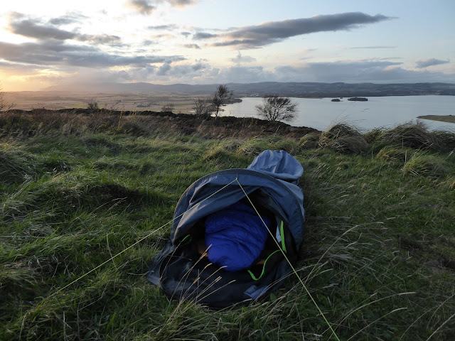
From here, another trail climbed up the gentle side of Bishop Hill to eventually reveal its more precipitous west face. This was my planned camp spot for the night. Bishop Hill is less prominent than East or West Lomond but its long north-south ridge forms the steep eastern boundary of Loch Leven, so the views over the loch are superb. I pitched the tent on the ridge as the evening sun broke free of the clouds and sank beyond the Ochil Hills which straggled westwards towards Stirling.
Next morning, I packed up early and headed north along the remainder of the ridge of Bishop Hill. A grainy, grey light bathed these local hills but further north the twin peaks of Ben Vorlich and Stuc a’Chroin were ablaze in pink and orange. Eventually, at the far end of the ridge, I popped down into Glen Vale, whose sudden, deep depths were quite a surprise. Over the millenia, a chasm has been carved out by water, exposing sandstone rock faces that were laid down 350-400 million years ago. One of the rock features is known as John Knox’s Pulpit as the 16th century religious reformer was known to have visited Glen Vale.
Leaving Glen Vale, I followed a vague path across fields of sheep to eventually pick up the trail that encircles Loch Leven. I followed the loch shore round to the RSPB centre on its southern edge and climbed the path up Benarty Hill which is also known as the Sleeping Giant. When seen from the north, the profile of the hill looks like a huge warrior in battle headdress lying on his back. I imagined that, like me, he was gazing up to a blue sky scored with straggly skeins of geese.
Dropping down the steep path on the south side of Benarty Hill took me to a trail through the beautiful autumn woods of Harran Hill. This in turn connected me to Lochore Meadows and a short final walk on the pavement to Lochgelly for a train home. This had been a modest trip, not very far and over small hills but I’d loved connecting it up by train, finding wildness close to home and discovering lots of new routes and places.
Fact File
Start: Markinch train station
Finish:Lochgelly train station
Photos: Flickr
Route: Followed the main street west out of Markinch, right at the roundabout then left along Cadham Road, right on Western Avenue, left up Pitcairn Avenue, right on Tanna Drive then left up Moidart Drive to the Pitcairn Centre. There are lots of trails around here so I had the Walkhighlands description of the to route to East Lomond handy. From East Lomond took the main path west to Craigmead, turned left on the road then the first track to the right passed Little Ballo. A path leaves this track and passes alongside the dam of Harperleas Reservoir. At the far side turned right along a track on the south shore of the reservoir. A path leaves this track signed for West Feal then turned right when it joined the track to the farm. Passes behind the farm buildings on the righthand side then climbs to Bishop Hill. Continued north along Bishop Hill then followed a path that dropped to the east to join the main route through Glen Vale. Stayed on the south side of the burn and the path passes into sheep fields before the first dirt track to the right which joins the unclassified road at Glenlomond. Walked to Wester Balgeddie then turned right on the A911 to Loch Leven's Larder - a lovely shop/cafe where there is also a path down to the Loch Leven Heritage Trail (follow the cycle signs). Followed the loch trail to the RSPB at Vane Farm and took the path out of the other side of the centre that goes to Ballingry. At the top of the climb joined the ridge of Benarty Hill. From the trig point a path heads southeast and joins the unclassified road from Ballingry to Lochran. Immediately opposite, took the track and then the path signed through Harran Hill. Walked to Crosshill through Lochore Meadows Country Park and then up to Lochgelly.
Info: Also, in normal times, a nice coffee shop at the RSPB centre with panoramic windows looking over the loch.


