Thursday, 4 July 2019

Torridon - The Tea House

The camp stove sparked into life with its reassuring roar, drowning out the noise of rain splattering on the window. Beyond the glass the river, swollen by two days of torrential Torridonian rain, was an avalanche of peaty water. It barrelled its way through the gorge with a menacing roar. In contrast, the Scots pine and birch trees that crammed the place were quiet and still with barely a shiver in their branches. Through late afternoon and into evening, the low-lying mist would occasionally clear a little, opening up a brief tantalising view of the rocky peaks above, before closing in again. This was my world as I passed the remainder of the day and the night in this place. Officially called the Easan Dorcha Bothy, it’s more affectionately known as the Tea House.


A few days before my overnight stay in the Tea House, I’d jumped off the Kyle train at Achnashellach and walked through to Glen Torridon. Heavy bursts of rain had cleared to a glorious evening of golden sunshine as I trekked up into Coire Lair. The tent was pitched on a high shelf backed by the jagged rock giant of Liathach. If I drank my evening cup of tea on a rock a few metres away from the tent, I had a view to a sea shimmering silver in the late light.


The next morning provided a personal record for me, being the latest date into summer (28 May) that I’ve walked in falling snow. It dusted the summer tops in white. However, it was quickly banished by a warming sun that provided two hot days of clear blue skies. I wandered the beautiful coastal woodland trails along the south shore of Upper Loch Torridon which provided that heady mix of mountain and sea. That night, a grassy promontory on the loch shore provided a stunning camp spot with a panorama of peaks.


And I climbed up Beinn Damh, a Corbett on the south side of the glen. The path rose steeply through scented pines before breaking out on top.  The views from here were astounding to the Torridon hills and the scalloped coastline. Across a sapphire sea, an undulating line on the western horizon marked the Outer Hebrides. Thereafter the clouds moved in and the only reward the next day for a stiff pull up Beinn Alligin was the ubiquitous rucksack-at-a-misty-cairn photo.


When the rain set in for the rest of my trip, I walked through the hill passes and woods to the Tea House. It’s a gorgeous wee bothy in a delightful, hidden spot. About the size of a large garden shed, it’s clad in cedar on the outside and has a lovely wood panelled interior which gives the place a nice homely feel. There’s a small table and a long bench where I laid out my mat and sleeping bag for the night. Visitor books going back to 2010 are lined up on a shelf beside the door. An older one had a lovely pencil drawing of the Tea House. A window on each side affords a view up and down the gorge, which I enjoyed sipping endless cups of tea until bed time. 


It was one of the loveliest places that I've spent a night. Though perhaps it wasn't the comfiest, as the bench was a bit narrow. I lingered a while the next morning, running my eye over the place one last time, before I continued through the hills to Achnashellach to catch a train home. 


Fact File
More photos on Flickr - click HERE
Start/finish: Achnashellach
Public transport: Inverness/Kyle of Lochalsh train stops at Achnashellach
My route: At the end of the platform, crossed the train line at the level crossing and continued on a forest track. At the first track junction turned left. A little further on, the footpath was marked where it left the track. Took this footpath north through Coire Lair and followed it through Bealach Ban and Bealach na Lice then continued on the path north to Annat. Picked up the coastal walk behind the Torridon Hotel and followed it west, finding a camp spot on the way back. The path up Beinn Damh is signed from this path close to the hotel. Walked on the road from the hotel to Torridon village and along the single track road that continues west along the north shore of Upper Loch Torridon. The road crosses a gorge with waterfalls beside a car park. On the west side of the bridge here the path begins for Beinn Alligin. From the village I then walked east along the glen road which was pretty quiet to Loch Clair. After the loch, the track begins south for the Coulin Pass. A couple of kms after the last cottages the track crosses a stone bridge. For the bothy, didn't cross the bridge but followed the track west and the bothy is just over a km further on. For the return to Achnashellach, I crossed the bridge and walked over the Coulin Pass, the track returning to the station.

Sunday, 26 May 2019

East Lothian - Backyard bicycling

East Lothian is a very varied area of southern Scotland, with green farmland, gentle hills, nice wee towns and some lovely beaches. It stretches eastwards from Portobello until the coast turns south. As it's right on my doorstep, I consider it my backyard. So here's a short backyard bicycle trip, right from the front door, that I did recently with my friend, Graham.

We connected quickly and easily to national cycle route 1 where it trundles beside the River Esk. It then passes through Whitecraig to continue along a delightful, old railway line.


We left the old line about half way along to make a connection to the Pencaitland Railway Walk. The railway line here was built in the late 19th century to serve the mines in the area but also carried passengers and agricultural goods. It closed in 1965 and is now part of the national cycle network.


East Lothian's excellent core path network took us away from the railway walk at Ormiston and along a series of lovely, lush tracks and paths that criss-crossed through the fields to Macmerry and Penston. We joined the cycle lane along the main road here to continue to the pleasant wee town of Haddington.


Another disused railway line then runs to Longniddry. It was stunning in mid May with the hawthorn hedgerows in full bloom. In autumn, these same trees create a dazzling red corridor when they are heavy with berries. We also passed under many old arched bridges.

We explored a new route from Longniddry down to the coast with a fun descent through Dean Woods. There was a bit of beach fun before taking the coastal cycle route back to Portobello.


Fact File
Start/finish: Portobello
Picked up national cycle route 1 at Brunstane Station and followed to beyond Whitecraig. The Pentcaitland Railway Path (NCN196) is signed from here, about half way along the old railway line. Left the Pencaitland Path just after it passes Ormiston and used the core path network signed to Macmerry. Continued straight through Penston and stayed right at the fork to join the A199 which has a wide cycle lane. At the next junction and roundabout continued into Haddington and the Longniddry path (NCN76) is signed from this main road into town. At the other end we continued along the A198 west using the wide footpath and took the path down through Dean Woods - on the left, just before dual carriageway starts. This goes to the coast and connects nicely to the start of the cycle path at Longniddry Bents which continues mostly off-road to Musselburgh. It's then the main road or the Brunstane Burn path back to Porty.


Sunday, 12 May 2019

Great Glen - iScoot

If I said to you that I've got a new "pair of wheels" you might think that I'd bought another bicycle! But, after thinking about it for a year or so, I eventually bought an adult scooter. My thinking was that it would turn a walk that was ordinarily a bit of plod into a bit of fun instead. My first trip with the scooter was a few days of hillwalking along the Great Glen north of Fort William.

I hopped off the train at Banavie which is a few miles west of Fort William and sits right on the Caledonian Canal. The canal towpath is a hard-packed, relatively smooth dirt surface and I thought it would be perfect for the scooter rather than walk the 6 miles to Gairlochy. It did the job really well, although it was more work than either walking or cycling, especially with a four-day pack on my back. But it was great fun and a wee bit different, attracting lots of looks and comments.


After my 6-mile scoot, I hid my wheels in the woods and set out walking along the route of the Great Glen Way. Here it passes along the shores of Loch Lochy and high above the waters were two Munros that I hadn't climbed yet. After a night's camping at one of the informal wild camp spots on the Way, I made a lovely walk up through the trees. Although the area was densely forested with commercials pines, the gorge that the footpath followed was crammed with deciduous trees and lined by primroses and violets, making for a much nicer walk. 


The path eventually left the trees and climbed to a high bealach between the two Munros. I pulled myself up the broad flank of the first one, Sron a Choire Ghairbh, just as a bank of mist blew over and obscured my views from the top. I returned to the bealach and sat a while munching a muesli bar. I'll never make a Munro-bagger! I was sitting so close to the second Munro and could have been up it in less than hour but didn't. I decided that I had enjoyed the journey here so much, scooting along the canal and walking the forest trails, that I would leave the other Munro unclimbed, thus giving me an incentive to do it all again. So I dropped down the far side of the hills to camp for the night.


Next morning I continued down to the shores of Loch Arkaig and on a hot, sunny day set out walking through the beautiful, cool woods of Glen Mallie. Where the woods ended I made a long walk to the head of the valley and the ruin called Glenmallie. It was a lovely spot here with drystone dykes forming an enclosure, clusters of trees by the river and my next target, the Munro of Gulvain, forming a dramatic backdrop. I decided I would camp here that night and hid my heavier camping kit behind the wall before continuing up the hill. I was very excited to see here, sunning itself on the track, my first slow worm. It's neither a worm nor a snake but a legless lizard. I also had good views of two golden eagles.


The top of Gulvain was a long time coming, over rough, pathless slopes and a steep boulder field on the final stretch. But what views from from the top. Knoydart stretched out to the west and Ben Nevis dominated to the south. I could see Skye and the Kintail peaks with the jagged outline of Torridon to the north. It was marvellous to sit up there in warm sunshine with a barely a breath of wind, procrastinating over the long walk back. The camp spot at Glenmallie was a long time coming and by the time I was back at my kit, I had walked over 30km and climbed a Munro! I sipped my evening cuppa looking back to the dark outline of Gulvain and fell asleep quickly.


My last day was a pleasant walk back to Gairlochy to pick up the scooter which was safe and sound under its rhododendron bush. Then back to Fort William along the canal on my final scoot of the trip.

Fact File
More photos including the slow worm on Flickr - click HERE.
Start: Banavie train stop
Finish: Fort William train station
My route: Up the Caledonian Canal from Banavie to Gairlochy. Followed the Great Glen Way towards Laggan. Just before Kilfinnan a side track heads to the left signed for the hill path. 2.5km along this track is the hill path, marked with a small cairn and walkers' sign. This is a big double-back but with dense forestry all around, I couldn't see a direct route. Most folk will arrive at theses hill by car and enter from Laggan so won't have this problem. The hill path climbs to a bealach between Sron a Choire Ghairbh and Meall ne Teanga and paths head off up both Munros, routes obvious in clear weather. I continued north along the path into Cam Bealach and the ruin at Fedden, dodging some deer fencing and bogs. I then picked up the path that passes southwest through Gleann Cia-aig and pops out at the start of Loch Arkaig, giving nice access to the hills in Glen Mallie. I followed the main track up the glen to the ruin of Glenmallie and beyond until it eventually comes to a stone dyke that traverses the hill. Followed the dyke to the bealach with the spot height 536 and from here it was a straight forward climb to the top of Gulvain. Returned to Gairlochy and Fort William same way.

Sunday, 14 April 2019

Raasay - Treading time

Raasay is a small island, 14 miles long north to south, that lies east of its neighbouring island of Skye. My journey there from home by bus and then ferry, for a few days of walking and camping, took an incredible ten hours. But it was a gorgeous journey marked by stunning transitions. Central belt city gave way to rolling countryside which was overtaken by the rugged mountains, coast and sea of the West Highlands. Then finally a boat journey across a choppy, frothy sea so you can feel you have truly left the rest of the world behind. Raasay is a lovely wee island, scattered with stuff from the past so you feel that it's ever present. Here are my highlights from my second visit in a grey, murky March week.

Calum’s Road
Since reading Roger Hutchinson’s book “Calum’s Road”, the place has risen to legendary status in my mind and yet, I missed getting up there on my first visit to Raasay. So this time I made the long walk north. 


If you don’t know the story it goes like this. Calum Macleod lived in northern Raasay in the small hamlet of Arnish. He was a crofter and part-time postman and lighthouse keeper. There was no road to Arnish, just a footpath. Concerned that this was leading to the de-population of the north of the island, Calum and the other local inhabitants campaigned for decades for a new road but were refused. Eventually Calum built the road himself, using not much more than a spade, a wheelbarrow and a road-building manual that he had purchased. In ten years he laid just under two miles of road to link Arnish to the main road on the island. Several years after Calum finished his road, the Council eventually adopted it and surfaced it with tarmac. At that time Calum and his wife Lexie were the last inhabitants of Arnish and when he died in 1988, Calum was taken away from Arnish by hearse on the very road that he’d built. 


A remarkable and moving story. You might think a sad ending but it's not so. A walk through Arnish today reveals six well-kept houses, three of them currently occupied and one with a young family. I know this because I passed the boy being driven to and from the primary school in the south of the island as I walked along Calum's Road. 

The delights of northern Raasay extend beyond Arnish. A stunning walk through stunted birch woods hugs the coast and takes you to the tidal causeway that links Raasay with another island, Fladday. Its three white-washed cottages stand proud against the elements. Imagine living there – an island that’s off an island that’s off another island!

The path to Inver
About halfway down the west coast of Raasay, a footpath leaves the main road, which is all single track by the way, and heads to the sea. En route, it follows a river as it passes through more of Raasay’s typical stunted birch woods. Soon you are wrapped up in the trees. It’s a quiet place, the woods providing shelter from the ever-present winds. The trees are covered with a myriad of different mosses and lichens, and overhang little waterfalls and pools. The boulders of a stone-built single-room dwelling are half hidden by vegetation as the structure is gradually smothered by nature. If you were a child, you would imagine that fairies live here. Where the river joins the sea, you are suddenly tossed out of the woods onto a wild, pebble beach with a white-frothed sea offshore and a sliver of a view to Skye.


Dun Cana
Dun Cana is Raasay’s only significant peak and it’s only 443m high but nonetheless, it’s a wee bit special. An extinct volcano, it has a bizarre outline with a flat, cut-off top and a band of cliffs that look like a pie crust. Given its splendid isolation from any other hill for miles around, the top is reputed to have a sensational 360 degree panorama of mountains, seas and islands. In two visits to the top in murky weather, I can only vouch for the view to Skye where the Black and Red Cuillin form an undulating line of rock on the westerly horizon.


Hallaig
If ever there was a place that gave you goosebumps, that made you linger and ponder the past, it is Hallaig. An old, old path leaves the last of the white cottages at Fearns and skirts round the southeast edge of Raasay. Above are tall, imposing limestone cliffs and below an angry sea, whipped up by a strong westerly. Once again, the path enters Raasay’s birch woods then clings precariously to the slope before popping out the other side to cleared land and the remains of lazy beds. Dun Cana rises dramatically above you here and on your right the sea stretches to the hills of the Applecross Peninsula. 


There’s a large, square drystone enclosure and dotted about the hillside, the remains of stone-built houses, gradually being reclaimed by nature. It’s like a miniature Machu Pichu. But there is one dwelling that is incredibly intact, bar a roof and windows, and its wholeness makes it so much easier to imagine the past and the people who lived here. 


Hallaig was Raasay’s largest settlement before the appalling Highland Clearances, that most disgraceful episode in our history when tenant farmers were forcibly evicted from their land. Walking through the rooms of the house, the wind whistling through the empty doorway, the sea growling below and Dun Cana rising above, you feel the presence of the past. Sorley MacLean, the Gaelic poet, was born on Raasay and on a cairn near to Hallaig are beautifully inscribed the words of his poem, Hallaig. I’ll finish with his opening words:

Time, the deer, is in the Wood of Hallaig.
The window is nailed and boarded 
through which I saw the West.

Fact File
More photos on Flickr - click HERE.
Start/finish: Ferry port, Raasay
Public transport: Citylink bus Glasgow to Skye stops at Sconser from where the Raasay ferry leaves regularly throughout the day.
My routes: From the ferry, followed the road round to the right towards the village, Inverarish. At the first fork in the road, stayed left and same again at the next one. Just after here on the right, the track called the Burma Road is signed. Followed that to the top and a path to Dun Cana is signed from here. Path ascends boggy ground and then passes along the top of a rocky escarpment before dropping down to Loch Na Meilich and continuing to the top of Dun Cana. When I returned to the escarpment, I didn't retrace my steps but took a path that heads northwest and joins the road further north. Walked the road to Brochel but just before, as the roads drops steeply, took a forest track to the ruined settlement of Screapadal which made a great camp spot for two nights. Walked on Calum's Road from Brochel to Arnish and continued on the dirt track beyond. Took the first footpath signed to the right and at the next path junction turned left towards Fladday. This makes a lovely circular walk from Arnish. Walking back down the island, the path to Inver starts on the right at Brae. For Hallaig, walked the road to Fearns which continues as a track then path to Hallaig. As well as these routes, there are many wonderful forest walks in the Inverarish area which filled a whole day. Look out for the Forestry Commission leaflet in the ferry terminal.
Info: My photos may look overlay atmospheric - I had very grey weather on Raasay with no decent light so used a creative function on the camera to enhance the pics a bit. The Community Shop in Inverarish is very well stocked, including some gluten free items. 

Saturday, 23 March 2019

Badenoch - Abracadabra

Badenoch is a well known area for me so here were a few days wandering familiar trails, enjoying the place mostly to myself before the busy season begins at Easter. And a chance to grab the tail end of this winter.

The first day was grey, still and clagged in with low cloud. There was not a stitch of snow bar what was perhaps hiding in the clouds on the higher tops. Linked to the train station and encircling the village of Newtonmore, is a wonderful route called the Wildcat Trail. It was a day for walking that route which has great variety to keep your interest when the big hills are hidden. The path starts by following the banks of the Spey which is already a significant river here despite its source being only a little further west from Newtonmore. The path then turns north, away from the river, and wanders across the moors. My favourite section is where the route passes through old birch woods high above the village. On a grey, quiet day with nobody else around there’s a prehistroic atmosphere to the place such that you imagine a pterodactyl might come swooping through the trees.


A pleasant offshoot of the Wildcat Trail is the quiet road up Glen Banchor and I pitched my tent beyond the road end, by the river. A favourite spot. When I unzipped the tent next morning, it was as if some magician had waved a wand during the night and said “Abracadabra”. The place was transformed from spring to winter by a blanket of fresh snow. A westerly gale scoured the hills, shifting yesterday’s low cloud and revealing a stunning panorama of snow-covered peaks in the golden hour of morning sunshine.   


That gale put me off my chosen hill about two-thirds of the way up as I was almost knocked off my feet in the gusts. A lower top had to do this time. Even then, it was a struggle to stay upright in the icy blasts. But the views were superb of winter hills and weather fronts that brought in fresh blizzards of snow, moving over the hills and engulfing everything in their path, including me. 


The snow showers persisted until the evening when I met my friend off the late train. As the skies cleared, we walked out into the black night under a sky sparkling with stars and pitched the tents on a snow-covered meadow by a bend in the river.


The last day saw us set out from Newtonmore in heavy snow to walk over the moors to Kingussie. Big, wet flurries  were ever at our backs. With a blanket of fresh snow, the old woods were monochrome that morning. 

As the trail approached Loch Gynack, tucked away in the craggy hills above Kingussie, the snow underfoot ended and the world magically returned to the mossy greens and purple birch of the first day. An ice-covered path climbed up steeply through the birch then crossed open ground to deposit us on the top of Creag Bheag. It’s a favourite wee hill of mine with a great view. But not today as snow-laden clouds piled through the valley.

Oh for a bit of magic now to clear it away.

Fact File
Start: Newtonmore Train Station
Finish: Kingussie Train Station
Public transport: Edinburgh/Glasgow to Inverness trains stop at Newtonmore and Kingussie
My route: Out of the train station, walk up Station Road towards the village but after the row of cottages on the left, the link to the Wildcat Trail is signed to the left. Follow this across the railway and down to the river where it joins the Wildcat Trail proper. The Wildcat Trail is well signed and encircles the countryside around the village. At the northwest corner of the trail, it joins the road up Glen Banchor. The tarmac road in Glen Banchor ends at a parking place but a dirt track continues west and gives acces to the hills. I only climbed the tiny top of Creag nan Abhag that day in the winds but it afforded great views. I used a faint track initially that leaves to the right just after the copse of trees on a knoll just after the bridge below the road end. For the walk to Creag Bheag, we used the Wildcat Trail to Strone and then took the track signed for Kingussie which ascends to the forestry ahead on the hill before swinging east to Loch Gynack. In the trees at Loch Gynack, there is a signpost for Creag Bheag and trails down into Kingussie.
Tips: Sit-in fishers suppers, including gluten-free, at Joe's in Kingussie at the main crossroads. 

Sunday, 17 March 2019

Inverclyde and Cumbrae - Who'd have thought

With a plan to get into some different outdoor areas of Scotland this year, I recently bought a batch of new OS maps to fill in some gaps in my collection. I even bought the Glasgow OS map. I did think I’d made a mistake when it arrived though, as there didn’t seem to be much outdoors on it. However, I did spot a dotted green line of cycle path heading off the southwest corner of the map which joined up with another on my new Inverclyde map. The green dotted line headed a long way south through Renfrewshire, quite close to the commuter belt and outlying towns around Glasgow. Despite that, it looked very inviting and therefore a plan was hatched with bike buddy Graham for our next cycle trip.

Our urban starting point was the train station at Port Glasgow. A fantastically steep climb here took us up to the cycle route along the Greenock and Johnstone Railway Path which passed high above the waters of the River Clyde. It was marvellous up here. In the February heatwave the views were a bit hazy but it must be great on a crisp, clear day when the view will extend to the Southern Highlands. The cycle route headed east towards Glasgow and then swung south for Kilbirnie passing along the pretty shores of Castle Semple Loch and all the while in a lovely traffic-free tunnel of trees.  We were never far from towns and the massive conurbation of Glasgow, so we were surprised how rural the route actually felt. 


The hazy sunshine gave way to spots of rain which soon organised themselves into a bit of a downpour as we approached Lochwinnoch. There was a great café here to sit out the rain and judging by the numbers of bikes propped against the wall outside, it’s a very popular spot with cyclists using this route. When the rain eventually went off late afternoon, we made the long climb above Lochwinnoch up into Muirshiel Country Park. There was a perfect wild camp spot by the river with a shelter and picnic tables, a few hundred yards away from the road end. I would never use a spot like this during summer but at the end of a wet, early dark day in February there was nobody else around. As we busied ourselves making temporary homes for the night, the gush of the river was a backdrop to the hooting of owls. After dark the view of the stars was superb. Again a surprise, given the nearby sources of light pollution.

Back on the bikes next morning, we cycled to the end of the path at Kilbirnie and made a mistake taking the A road over the hills to join the west coast at Largs. Given it was Sunday morning, we had thought it would be quiet but it was fast, quite busy and downright unpleasant. There is a longer quiet minor road as an alternative and I made a note to self to use that next time. There were two reasons for heading over to Largs. Firstly, from here the map showed a tiny, unclassified road though the hills back to our train at Port Glasgow. And secondly, it gave us the opportunity to take a short ferry ride to an island neither of us had visited, Cumbrae. 


I had always imagined Cumbrae and its main settlement, Millport, to be quite twee and genteel. And in some ways that was true. But what blew me away about the place was that it also has very rugged surroundings that imparted a whole different atmosphere to the island. All around was the rough, crenelated coastline of the land and a sparkling sea where other islands, such as Bute and Little Cumbrae, drifted offshore. And the stunning backdrop to all this was the jagged, mountain ridge of Goat Fell and Cir Mhor on the island of Arran. The other wonderful thing about Cumbrae is the lack of cars so you can really enjoy the circular cycle around the island, taking in all these stunning views and stopping for a picnic on one of the beaches.


After a dreamy few hours in the sunshine of Cumbrae, we took the ferry back to Largs to pick up the wee road through the hills. This was another wonderful route with only a few slow-moving cars. About halfway up the road, we found another great wild camp spot at a picnic area in the trees and enjoyed a relaxed evening sipping soup and cups of tea at the tents. 

It wasn’t far from our camp spot next morning to continue over the watershed of the hills and return to Port Glasgow. Our route took us along lovely quiet farm roads and forest tracks that hugged the shores of huge reservoirs and undulated over gentle, rolling hills. Snowdrops were everywhere in big clumps and yellow daffodils burst from the hedgerows. 

It had been a brilliant trip with great routes and surprisingly stunning views of coast, islands and mountains. Who’d have thought at first glance at the maps that would have been the case.

Fact File
Start/finish: Train station, Port Glasgow
Public Transport: Train from Glasgow Central Station
Route: Out of the station we turned left up the hill, took a right on Kinross Avenue then a left on Barr’s Brae which the cycle route crosses. This is National Cycle Route 75 which we followed to Kilbirnie. We used the A760 from Kilbirnie to Largs – not recommended. On Cumbrae a road encircles the island and another climbs across the middle. Took the C41 out of Largs to Loch Thom. Made a wee detour to Cornalees Bridge, a nice spot with a visitor centre for the Greenock Cut and a café. Cycled along east shore of Loch Thom then a forest track along the south shore of Gryfe Reservoirs which joined a lovely wee farm road that took us to the B788. We turned left then right to rejoin the cycle path back into Port Glasgow.
Info: Great coffee shops in Lochwinnoch (The Junction) and Quarriers Village (Three Sisters Bakery). Quarriers Village is well worth the detour. It’s a very pretty village founded in 1876 as The Orphan Homes of Scotland by shoemaker and philanthropist William Quarrier.

Friday, 1 March 2019

Garleton Hills - I've been there

Few little hills that I know of pack the punch of the Garleton Hills in East Lothian. These small pimples above Athelstaneford have a wonderfully isolated situation such that the 360 degree views are superb. At least they were on a crisp, clear February day when I jumped off the North Berwick train at Drem to tackle the hills. They were the last hills that I hadn’t climbed that I can see on my local horizon from Portobello. 

The folding bike transported me from Drem to Athelstaneford along a pleasant network of paths and farm tracks. They rose gently to the wooded ridge of Kilduff Hill before dropping down again into the village. Athelstaneford is the birthplace of the Scottish flag, the Saltire. The story goes that on the morning of a battle between the Scots and the English in 832AD, the Scots saw a white cross formed by clouds in the sky. Winning the battle, the Scottish forces attributed their victory to the blessing of Saint Andrew, adopted Saint Andrew's cross as their flag, and named him their patron saint. 


A footpath sneaked out the far side of the village and crossed a field before dropping to the pretty gorge of the Cogtail Burn. Morning light flooded the woods here and illuminated swathes of snowdrops. The path climbed again and it was beyond here that the views started to open up as a track ascended the spine of the hills beyond the farm at Barney Mains. Walking across the top here, there’s an incredible sense of openness, space and big skies. These hills are made of layered volcanic rock subsequently scoured by glaciers. The highest point is only 186m but the panorama took in the Lomond Hills across the Forth to the north, the Pentland Hills and Edinburgh to the west, the Lammermuirs to the south and to the east was North Berwick Law and the Bass Rock. I could even see the Isle of May. 


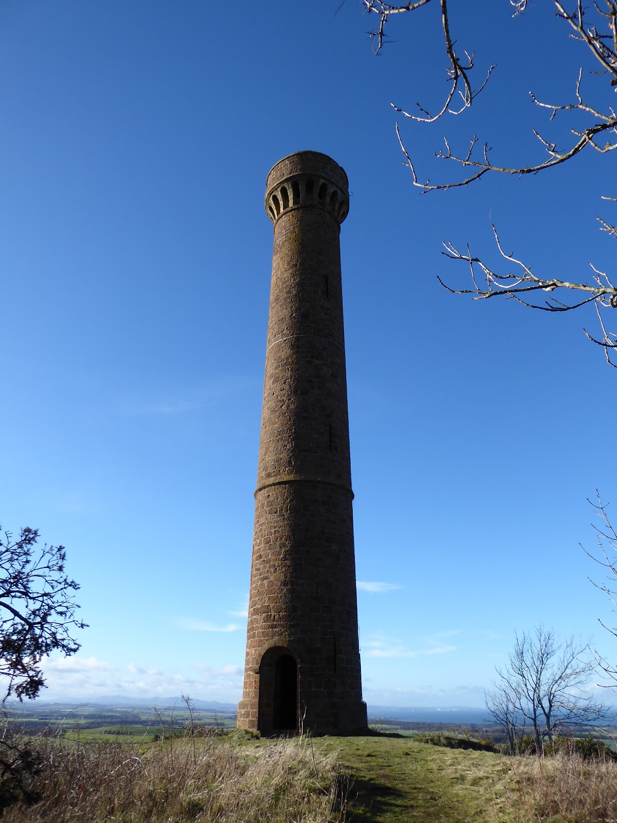
The most immediate view from here however is to the adjacent Byres Hill which hosts the impressive Hopetoun Monument. Returning to the village, I jumped back on the bike to cycle round there. Byres Hill was very different to Barney Mains. Its paths were wrapped up in a dense cloak of shady woods that stole the sense of space. But they were beautiful woods, dappled by sunshine, alive with birdsong and echoing with the shouts and giggles of children playing amongst the trees. A steep path that catches the breath pulled up through the trees to the base of the Monument. It was erected in 1824 in memory of John Hope, 4th Earl of Hopetoun, and is 29m high. If you bring a torch, you can go up inside. 

Back on the bike, I pedalled hard to make the early afternoon train home so I had time before the early dark of February to sit on the prom and look east to the Garleton Hills. Finally I’d come to know those little pimples on the horizon and say “I’ve been there”.

Fact File
More photos on Flickr
Start/finish: Drem train station
Public transport: Edinburgh to North Berwick train stops at Drem.
My route: Out of the station turned left then left again onto an unclassified back road which crosses the railway line. Where it crosses there is farm road straight ahead running south to Kilduff Hill. Kept left heading east when it reached the woods. 1km further on a junction is signed for Athelstaneford. Turned left when this path joined the road and cycled along the main street of the village. Up the east side of the school the path for the Garleton Hills is signed. Chained up the bike here. Path dropped to the Cogtail Burn and then climbed to join a farm track. Turned right on the track to the top of the hill, skirting the farm at Barney Mains to the left side and then picking up the track again. The route around the farm was signed and easy to follow. From Athelstaneford cycled west along the quiet B1343 and just before it joined the A6137, Byres Hill was signposted. Paths up the hill were obvious.