Tuesday 26 April 2016

Dalwhinnie - Tail end of winter

The days are lengthening now and there's a hint of warmth in the sun when it's out. Winter may be on the wane but Rob and I were happy to steal a final wintry weekend in the hills above Dalwhinnie.

Late evening we biked to Loch Pattack along a dirt road and into a stiff wind that the ruffled the grey waters of Loch Ericht. Spots of rain fell and the darkness advanced so that eventually we put on our bike lights to illuminate a small patch of trail ahead. Rob's new tent went up on my favourite wild camp spot hereabouts. It's a wide open place with mountain views and big skies where the river flows silently under the wooden slats of a shoogily bridge before emptying into the loch. In the wind and the darkness we were glad we'd practiced pitching the tent the previous weekend between the daffodils on Rob's lawn.

We lay late next morning listening to the pitter-patter of rain on the tent and the distant warble of black grouse, then opened a sliver of door to watch snow falling. But the forecast had been right and by late morning the day dried up and brightened. We continued along the lochside track watching a pair of whooper swans out on the water, perhaps pondering their flight to Iceland to breed. Our boots came off for a river crossing then we followed a rough path to Creag Pitridh, eventually pulling up into the snow.

Creag Pitridh is a modest hill itself but the views to its higher neighbour, Beinn a' Chlachair, were spectacular. Steely grey clouds drifted around it's snow-sculpted edges while sunlight illuminated its fine lines. Our return route found a path that passed along the edge of the snowline on a shelf above the waters of Loch a' Bhealaich Leamhain. Several point avalanches scarred the steep east face and had sent down snowballs in spiral patterns.

Next day dawned grey again with the hills covered in low cloud as we biked south through Drumochter. We hid the bikes in heather before slogging up the boggy slopes of Sgairneach Mhor. 


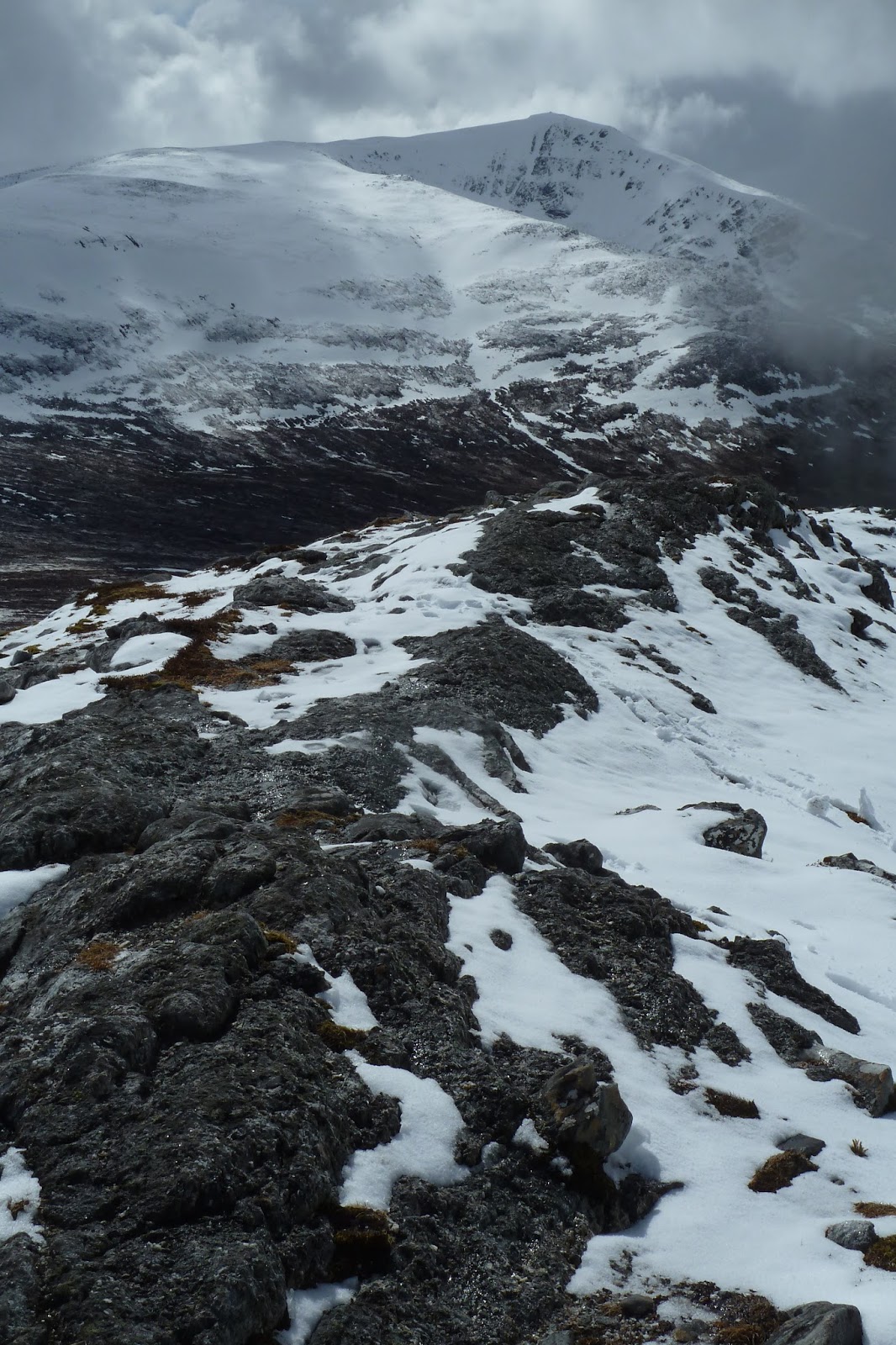
Eventually our boots were on the snow again as we walked along the massive cornice edge overhanging the hill's north side. A crack line was forming and it seemed like the gentle push of a boot could send the whole lot down into the glen. We were lucky again with the weather and by the time we were striding across the broad top, the cloud had cleared and the sun beat down.

Visibility was crystal clear and our view stretched westwards to Rannoch Moor and the snow-streaked peaks of the Black Mount and Glen Coe. Closer to, the massif of Ben Alder and its near neighbours still held huge amounts of snow.

lt's always difficult to walk away from the top of a mountain on a beautiful day like today but eventually we turned our backs on the views and on this year's winter. A bit of heather bashing took us to the glen below and a downhill bike ride put as back in Dalwhinnie.

Fact File
More photos on Flickr - click here.
Start/finish: Dalwhinnie
Public transport: Glasgow/Edinburgh trains stop at Dalwhinnie.
Route for Creag Pitridh: Out of the station turn right along Alder Road and cross the level crossing at the end. Continue straight along this track, passing to the right of the estate gate house and then along the shores of Loch Ericht. The track splits eventually but hang right and climb uphill. Eventually Loch Pattack will come into view and at the loch take a lefthand track that follows the water's edge. After the second bridge take a right hand split in the track and follow it to a ford over the Allt Cam. Pick up an obvious path on the other side. Follow this path up the east side of Loch a' Bhealaich Leamhain and onto the bealach between Creag Pitridh and Geal Charn. We struck up the hill on its south side skirting crags and found a bit of a path in the snow. We returned via the path that passes above Loch a' Bhealaich Leamhain on its west shore then picked up the outward route.
Route Sgairneach Mhor: From the station in Dalwhinnie cycle down Station Road and turn right on the main street. Just before this road joins the A9 the cycle path to Pitlochry leaves to the right. Follow it as far as a track heading down to a cattle creep under the railway at grid ref NN636742. Turn right on the other side and follow this track to a bridge over the Allt Coire Dhomhain. Cross the bridge and strike up south towards the point at 758m before turning southwest to Sgairneach Mhor. A faint path crosses boggy ground then joins a firmer path along the top of the ridge to the broad top. We returned via the same route.

Thursday 14 April 2016

Fife - Trundle through Tentsmuir

Just across the water from my home in Portobello, is the Kingdon of Fife - great  for a quick escape and a bit of variety. Here are some pics from a mini tour I did a couple of weekends ago with bike buddy, Graham.

Our wee tour started on Saturday afternoon by taking the train to Dundee and cycling back over the River Tay. Despite the proximity of traffic, I always enjoy cycling the Tay Bridge.
On the other side the route headed east along the coast to the pleasant village and harbour at Tayport where we picked up water for a wild camp later. 
The route hugged the coast where mud flats were revealed by the low tide. We passed "dragon's teeth", the name given to the jagged line of concrete war defences. On the other side of the water stood an older defence, Broughty Ferry Castle.
It was early evening when we cycled into the pine forests at Tenstmuir and set about looking for a spot to camp. On a grey night that was threatening rain, we seemed to have the place to ourselves. The tents were pitched on a grassy shelf between a thin line of birch and the sandy beach.  The dusk time air was filled with birdsong and breaking surf.
Next morning we set out in heavy rain and meandered across Fife, passing over the backbone of its little hills via the High Road.
Next stop was the village of Ceres. We tipped our hats to the famous 18th century statue of the Provost and ate lunch overlooking the quaint village green.
The sun finally broke through as we rounded Fife's Lomond Hills and headed to Thornton to catch a train back.
Fact File

Start: Dundee railway station
Finish: Glenrothes with Thornton railway station
Map: OS Landranger 59
Route: From Dundee station follow national cycle route 1 signs over the Tay Bridge and eastwards to Tayport and Tenstmuir Forest. Continue on route 1 through through Starthkinnes or divert via a traffic free route to St Andrews. Continue on route 1 to Ceres via Kemback then beyond Ceres the route passes over Cults Hill. Just beyond here it junctions with cycle route 76. Follow route 76 to Thornton and the railway station is to the left of the main road through the village.


Tuesday 5 April 2016

Kilpatrick Hills - The four stages of the Tour de Whangie

I'm not ashamed (well, maybe just a little) to admit to reading the Scots Magazine. For many years it's been squashed into my rucsack or panniers to provide some light reading as I head off to the hills for the weekend. Mind you, these days I more often take my smartphone having packed it with downloaded online articles to read. My favourite downloads at the moment are archived Tom Weir articles from the Scots Magazine during the 1970s and one of those really whetted my appetite for a wee place hidden away in the Kilpatrick Hills called the Whangie (it sounds good if you say it with a Glasgow accent). A quick look at the map showed a cycle tour between the train stations at Dumbarton and Milngavie with a short detour to the Whangie and I set out to ride it on a grey day in the middle of March. The mini tour broke down into four neat and quite distinct stages.

Stage 1 - North from Dumbarton
Be very afraid when the new man in your life (called Rob) arrives for your first bike ride together on wheels emblazoned with the words "Rapid Rob". Well, Rapid Rob and I cycled north out of Dumbarton following the fast-flowing waters of the River Leven passed dreary urban sprawl to Balloch. Beyond Balloch things got better and we meandered along a series of lovely country roads and a new bike trail that took us to the quirky Pipe Bridge. It was a slightly unnerving cycle across as the iron grid platform made us wobble high above the river below. At the end of the first stage, I shoud put the record straight and point out that Rapid Rob is the brand of tire on Rob's bike - a pure coincidence when he bought it!

Stage 2 - The West Highland Way
As we cycled away from the Pipe Bridge our route joined the West Highland Way and we turned south, cycling past groups of heavily loaded teenagers setting out on their long walk north to Fort William. Some looked miserable and sultry while others were in high spirits and belting out music. I envied them for their adventure ahead - there's nothing like that first big step into the great outdoors. The Way was a nice single track here that twisted through the woods but we cursed the endless, and often pointless, gates that forced us to keep stopping.


Stage 3- The Whangie
A short detour from the West Highland Way took us to the Queen's View where we chained up the bikes and set out on foot to find the much anticipated Whangie. A bit of contouring round the hillside opened up views of Loch Lomond, although Ben Lomond itself stayed hidden under low cloud. When we got there the Whangie was more than enough compensation. The Whangie is a bizarre rock feature on the side of the hill created by glaciers in the last ice age slicing open the crag. Although the local story tells that it was made by the devil flicking his tail as he flew past. Today the feature is a deep canyon with walls 50 feet high and a sliver of a path meandering through. It's a magical place with a primeval atmosphere.

Stage 4 - Mugdock Country Park
Back on the bikes, we continued cycling south and entered the wooded trails of this country park north of Milngavie. The routes were pretty churned up in places so I will affectionately remember it as Mud-dock Country Park! We got a little lost in the maze of routes here but as a chink of late afternoon sun broke through the clouds all roads eventually led to Milngavie and the train home.

Fact File
Start: Dumbarton Rail Station
End: Milngavie Rail Station
Route: Out of Dumbarton station follow national cycle route 7 signs north via Balloch on traffic free bike paths and quiet back roads. Just beyond Croftamie and the Pipe Bridge, route 7 meets the West Highland Way. Follow the West Highland Way in the direction of Milngavie. At Easter Carbeth the way joins the B821 - turn right and then right again onto the A809. After a couple of kms you reach the car park at Queen's View. The path to the Whangie leaves from the back of the car park and is a well trodden route up the hill. Return to the West Highland Way and follow it south to Milngavie where it ends in the vicinity of the train station.