Saturday 21 December 2019

Corrour - The old favourite

With the first snow on the hills and cheap rail tickets on offer, it was time for an early winter visit to one of my favourite places – Corrour. It’s hard to believe but I’ve been going there for over twenty-five years now. If you don’t know it, it’s a remote stop on the West Highland railway line where it crosses Rannoch Moor. There is no road access, just the train and a number of tracks and trails that radiate out from the station in every direction into wild hill country. 


My friend Graham and I got the morning train and jumped off at Rannoch, the stop before Corrour. Over a few hours we walked north towards Corrour on the old Road to the Isles. It’s a rugged track that passes high above the moor on the flank of Carn Dearg and it was wonderful walking there that day. The low winter sun created a beautiful, soft light that picked out the snow-covered hills all around us and illuminated the russets of the spent summer grasses. 


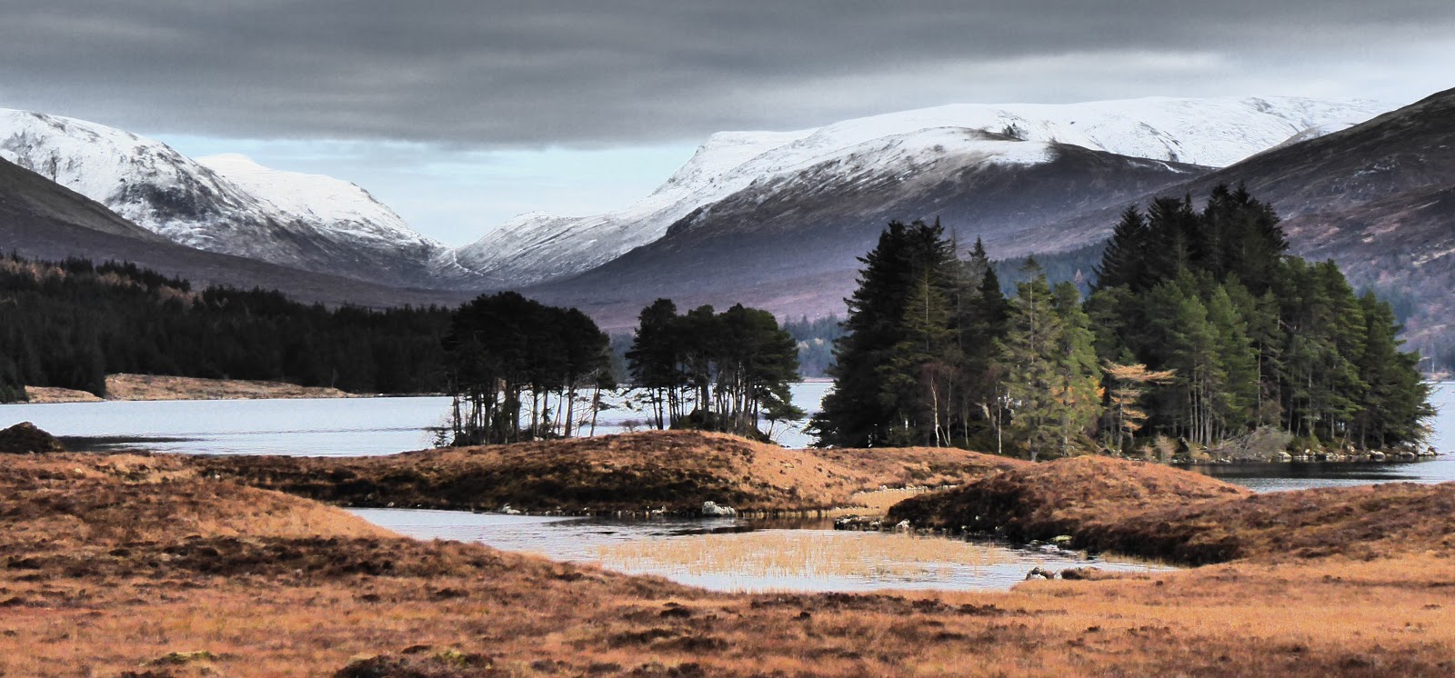
Because the track is so high, it affords a wonderful, airy view over a landscape of moor and mountain. Our panorama stretched from the Bridge of Orchy hills, over the Black Mount to Glen Coe and then west to the Mamores and Ben Nevis. Scotland is at its most stunning in winter light and a dusting of snow. It looks so much more elemental and I love the elements, the feeling that, even in the modern mechanised world, they are still our master. 


Where the Road to the Isles began its descent towards Loch Ossian, we turned off onto a rougher, more vague path. It felt wilder than the track and cut a lovely line across the moor down to the old ruin. The path was firm and obvious in spots but in other places, there was only a suggestion of where people had walked before. But I know this route. It’s become familiar to me over the years in the same way as I know the old ruin and feel comfortable in its company. In the late afternoon, which at this time of year is closer to night, we pitched our tents on my favourite spot on the east side of the house. I wonder how many more years its walls will withstand the brutal elements.


It’s always wonderful to spend time here. The old ruin sits close to the railway line, just south of Corrour, and is set in a natural amphitheatre of wild hills. I wanted to stay outside of my tent as long as possible to suck it all in but the cold eventually forced me in inside. And what a cold night it was. A night for wrapping up in thick wool layers and our warmest sleeping bags. We did go out again later to watch the southbound, evening train pass. The squares of orange light from its windows were all we could see in the pitch darkness.


A cold, clear day followed after a late-rising sun that bathed the hills in golden, morning light. We had to shake ice off the tents before packing up. Our route continued north on the path towards Corrour. Having stashed our heavier camping kit, we set out up Beinn na Lap, a whaleback of a hill that rises above Loch Ossian. The path that ascended the flank of the mountain was ice-covered and treacherous in places, so we were glad to reach the ridge with its soft, powder snow. As we gained height, the moor was left far below and the station building at Corrour looked like a tiny monopoly house. The mountains now seemed to crowd in around us in layer after layer of snow-kissed ridgeline. 


We had also left below the marginally milder temperatures and continued up into a world of snow and rock, blasted by a fierce, Arctic wind that scoured the top of the hill. We donned our extra layers and ultimately our duvet jackets, all of which enabled us to sit for ten minutes at the top. But that was all the elements allowed us and we began our descent. 


I was enjoying the snow and the wild elements so sauntered down quite slowly while Graham was much faster ahead of me. I watched him as he reached the snowline again and repeated in reverse the process of layering up. And I watched his tiny figure reach the flat ground of the moor at the bottom of the hill. Amazingly, in 2020, Graham and I will celebrate twenty-five years of friendship. Through that time, we’ve enjoyed so many outdoor adventures together, just like this one. Our tents have been pitched side by side in countless places in Scotland and abroad. He’s been my bike buddy and my hillwalking chum. He is my old favourite.


Fact File
More photos on Flickr HERE
Start: Rannoch Station
Finish: Corrour Station
Public transport: Train by the West Highland Line
My route: Out of Rannoch walked east along the road then left onto track signed for Fort William via Corrour. About 1km after the ruin, Old Corrour Lodge, took the path that descended west towards the railway line. A few hundred metres before the ruin, a track branches to the right and continues to Loch Ossian. Turned left on reaching the good track, then right after the hostel, then forked left after the bridge. The path up Beinn na Lap begins here, ascending north onto the ridge then north-east to the top.

Saturday 7 December 2019

Black Mount - The Way

In the last blog, I used a fledgling section of the West Highland Way long distance path as it started its journey out of Milngavie. Soon after, I found myself on it again. Much farther north this time, where it had matured into a rugged route that traversed mountain terrain. I used it to walk from the train at Bridge of Orchy into the Black Mount hills for a few days of camping and hillwalking. 


I'd maybe two hours of daylight left as I stepped off the afternoon train and used them to walk over the high pass, Mam Carraig, then to detour alongside the waters of the Abhainn Shira to a camp spot I'd used before. As I pitched the tent, the last rays from the sinking sun cast an Alpenglow on the snow-capped peaks that rose above. A cold night followed which left the winter's first frost on the tent next morning. 


I packed up and started the steep climb up Stob a Choire Odhair, a Munro in the Black Mount range that rises above the wooded shorelines of Loch Tulla. 


Higher up it was good to feel boots on snow and enjoy the wintry panoramas from the top. The snow picked out the coires and ridgelines, and contrasted with the lingering, rich tones of autumn. It was bitterly cold on the top so I didn't linger long before descending and rejoining the West Highland Way.


I wanted to wander the section of the Way that headed north across the moor here. And I'd a hankering for the moor's big, boreal, barren-ness. The stony track under my feet as I walked north was one of Telford's Parliamentary roads. These were built in the early 19th century as the old military roads had fallen into disrepair and were not suitable for the increasing amounts of commercial traffic. It served as the main road north until 1933. 


Today it carries the West Highland Way from Inveroran through to Kingshouse and it's a lovely section. On your right as you walk north, the flat bog of Rannoch Moor stretches eastwards, its emptiness and simplicity beautiful in their own way. On your left, the rocky peaks of the Black Mount rise sharply above, a medley of foreboding, rock ridges and snow. These hills spawn the River Ba which crosses under the Way at the old Ba Bridge. It's a pleasant spot with a rocky gorge and a cluster of golden birch trees. I pitched the tent here on one of the few non-boggy spots for miles and watched the light fade beyond the hills.


My third day was a walk back south along the Way to catch a homeward train with a detour up a little hill called Ben Inverveigh. It's only 639m high but I loved walking there. Its summit is set far back at the west end of its ridge which penetrates into wild country. Its pathless, little visited slopes felt wilder and more rugged than the well-trodden Munro I was on the day before. Also these small, isolated hills can often afford wonderful views of their bigger neighbours. So it was with Ben Inverveigh which overlooked the Black Mount hills and the Ben Starav group. They appeared to the north as a snow-dusted, sweeping wave of high ground.


There was one more detour from the Way before the train and that was into the Bridge of Orchy Hotel for a quick supper. The hotel is a bit of a legend in hillwalking circles and, despite it being gentrified over recent years, it's still largely populated by grubby walkers with muddy boots and noses sniffly from the cold. It was just as well. Knowing I was having my tea out, I'd kept myself pristine for the three days in the hills but somehow managed to step into a peat bog about 50 metres from the hotel. I arrived for dinner as black as the Black Mount hills.

Fact File
More photos on Flickr: click HERE
Start/finish: Bridge of Orchy
Public transport: Citylink bus or train to Bridge of Orchy from Glasgow
My route: Followed the WHW path out of the station (turn left on exiting) and to Forest Lodge. Turned left here (signed Loch Etive) to camp first night a little way up the river and pick up the path up Stob a Choire Odhair just after the old school house tin hut. After the hill returned to Forest Lodge then took the WHW north, camping at Ba Bridge where there are a few good grassy spots for tents. There wasn't much before that. On the way back to Bridge of Orchy on the WHW, a grassy track leaves to the right at Mam Carraig, the high point between Inveroran and Bridge of Orchy. It peters out where it gains the ridge but it's pleasant walking along the ridge to the top of Ben Inverveigh.


Saturday 23 November 2019

Campsie Fells - Fire-sitter

It was a beautiful, late autumn morning. There was barely a ripple on the surface of the loch and early sunbeams caught the reeds along the edge so they appeared alight. Wisps of mist hung above the water and were threaded through the lochside trees which were every shade of autumn - russets, golds and lingering greens. The only sound was the gentle gurgle of the little stream, running beside the bench I was sitting on. To get to this place on the shore of Craigallian Loch, I'd walked a couple of miles north on the West Highland Way path out of Milngavie. I'd come to see something very special that had been in my consciousness for a couple of years now. Something that had ignited wonder in my imagination since I first heard about it. I'd come to the Craigallian Fire memorial. Here's its story.

During the years of the Depression between the two World Wars, working class people from Glasgow escaped the city and their poverty by heading to the hills to the north, to the Campsie Fells and beyond. The first stopping point as they walked north, a place which they could reach after work (if they had a job), was the spot I was sitting at now on the shore of Craigallian Loch. 


There was a fire kept burning here continuously between the wars and on into the Second World War, offering warmth, a cup of tea and companionship. Around the fire, stories would be exchanged of adventures on the hill. But the fireside chat also extended beyond climbing to socialist politics and land access. In those days, which seem barely a blink of an eye away, ordinary folk did not have the same rights of access that we enjoy now. These gatherings also spawned the early, working class climbing clubs such as Creag Dubh and Lomond. But most significantly of all, the pioneering spirits that came together at the Craigallian Fire are widely considered to have planted the first seed of our modern land reform which has led to the extensive freedom we enjoy in the hills today. The people that gathered round the fire were known as fire-sitters.


A beautiful, sculptured stone fire is placed as a memorial on the spot today. How wonderful it was that morning to sit at the "fire" and soak up the atmosphere. I marvelled at the fact that the stream gurgling beside me was the same one that the original fire-sitters would have collected water from for a brew. I tried to picture faces gathered round, flickering in the flames and their talk as red as their rosy cheeks. And I squinted my eyes to imagine another ragged walker with makeshift knapsack coming along the path. On a moonlit, cold winter's night they sought a cup of tea, friendly chat and a place to sleep. But mostly I sat quietly by the fire and paid my respects to those people who changed life for the better for ordinary folk.


As the morning was creeping on, I left the fire and pressed on northwards. I wanted to climb a little hill an hour or so further on that many of the fire-sitters must have climbed in their day - Dumgoyne. The West Highland Way path took me most of the way there as it passed through farms and woods. A grey, cold day had replaced the early sunshine.


At only 427m high, what Dumgoyne lacks in height, it makes up for in character. A volcanic plug, its steep slopes and crags are the dominant landscape feature hereabouts. As I pulled myself up the hill, the views that opened up were new to me - a different angle on Ben Lomond and Conic Hill, and the southern edge of the Trossachs. The view was murky but to the north there was a suggestion of snow-covered, bigger hills. I'd little time to enjoy it. I'd just made it to the summit boulder when the mist that had hung below the cliffs billowed in like dense smoke and engulfed the top of the hill.


I made my way back down, caught the next bus to Milngavie and the subsequent train home. But since this wee trip, I can't stop thinking about the fire and the fire-sitters. It's such a beautiful story and a little bit of history that has touched me deeply. I feel drawn back to the fire. One day I want to be that ragged walker coming along the path on a winter's night, seeking a place for the tent and a spot by the fire.

Fact File
More photos on Flickr - click HERE
Start/finish: Milngavie train station
Public transport: Train to Milngavie. Stagecoach bus from Dumgoyne Distillery back to Milngavie.
My route: From the train station followed signs to the high street and halfway along is the start of the West Highland Way - can't be missed as there are beautiful rusted panels depicting the highlights of the route. Followed the WHW north. The memorial is set in the trees at the side of the path beside Craigallian Loch. Left the WHW as it approached Dumgoyne Distillery, walked past the Distillery and took a tarmac track to the right that climbed passed some cottages then became dirt track. Round the edge of fancy gates and then passed in front of the higher cottage. Track crossed field and before the pine trees a grassy path heads off left and up Dumgoyne. 

Monday 11 November 2019

Mull - Ferry-ness

Cycling around Scotland's west coast and its many islands inevitably involves taking a lot of ferries. These are not just a means of bridging the watery miles but are a wonderful, and quintessentially Scottish, experience in their own right. I absolutely love using the ferries and my autumn cycling trip to Mull provided plenty of opportunities to do so. But I also had a ferry experience of a slightly different nature.

As I jumped off the Oban train at Connel and started cycling north along the beautiful coastal cycle path, I was en route to a very special event in Ballachulish. My friend Graham was holding a preview in the village hall of his new film. It's all about ferries! More precisely, it's about the ferries that operated on the Ballachulish crossing before the bridge was built. As I've helped a little with the film (and even made a cameo appearance), I feel quite attached to the project and was really looking forward to the preview.


The cycle north was idyllic. As I pedalled over fallen autumn leaves, the sea and the rugged peaks of Ardgour stretched out to my left. There was a nip in the air that said winter was just around the corner. 


I arrived in Ballachulish with plenty of time to help Graham set up the hall and we opened the doors to a flood of people. By the time the film started, the hall was packed full. The event was a great success and quite an emotional evening as many folk who had fond memories of the ferries had attended, including many who'd appeared in the film. There was a lot of chat afterwards, no doubt as people exchanged their ferry stories.


With the film premier behind me, I set out cycling again, hopping onto the Ardnamurchan peninsula via the Corran ferry. It's a peculiar looking craft with its asymmetrical ramps, designed specifically for this short crossing south of Fort William. My road meandered west through Ardnamurchan's autumn woods and undulated along the shore of the sea loch, Loch Sunart. 


The weather was what you might call "atmospheric". Showers of light rain and banks of mist drifted in off the sea and hung around the woods and lower slopes of the hills.


At the end of my road on Ardnamurchan, there was another ferry that made a rough crossing on a lively sea to Tobermory on the Isle of Mull. Unlike the big, sleek ferry that does the main Mull crossing, this little one bobbed around like a bathtub and made slow progress in the swell. Tobermory is Mull's largest town and its pretty harbour is one of the most famous views in Scotland. 


From Tobermory I climbed on the skinniest of single track roads. It was steep but the reward at the top was a beautiful coastal view taking in Ulva, the neighbouring island, and the Treshnish Isles, which were scattered further offshore. My road then plummeted down to Mull's west coast. The rugged shoreline here was backed by the misty outlines of the big hills, such as Ben More, in the south of the island. 


This was great cycling but my excitement ramped up even more as I approached my favourite stretch of road on Mull - the narrow coast road that hugs the shore below the Gribben Cliffs.  The road is the narrowest shelf of land between sheer, rock cliffs and the wild sea. It must be closed at times in westerly storms when the road will surely be swamped by waves. I love to cycle here - it feels so wild, especially in the persistent atmospheric weather!


A further hill climb round the edge of the cliffs took me to Mull's east coast and an undulating ride to the small settlement of Craignure. Here I would catch my final ferry of the trip to Oban for the train home. What a stunning ferry journey it was. A drop in temperatures overnight had laid the first snow on the hills and they looked so beautiful - snow-capped peaks plunging into the sea. 


On the ferry and with my bike secured on the car deck, I made my way to the upper lounge which provided warmth on a cold, cold day. It also provided a gorgeous view back to Mull's own snow-dusted hills as we pulled out into the open sea. The ferry passed the Lismore Lighthouse, almost close enough to touch, then negotiated offshore skerries to dock in Oban.


I'd time to kill before my train which was perfect because I love hanging out in Oban. It's the main hub for ferries to the Outer and Inner Hebrides so there's a constant air of coming and going, of journeys beginning and ending. So until my train was due, I sat on the promenade, watched the boats and soaked up some final ferry-ness.

Fact File
More photos on Flichr - click HERE.
Start: Connel
Finish: Craignure, Mull
Public transport: Return train to Oban but on the way up got off at Connel which links directly to the cycle path.
Route: From Connel used National Cycle Network 78 north to Ballahulish and onto Corran. Cycle main road west in Ardnamurchan (quiet in October) to Kilchoan then took the Tobermory ferry from here. From Tobermory cycled over to Dervaig then took the left after the bridge - a great little road. When I reached the west coast road, turned left and then right at Gruline to cycle to Craignure.
Info: Graham's film is called The Last Ferries of Ballachulish.

Saturday 26 October 2019

Kinross-shire - Sleeping on the Sleeping Giant

Few natural events are as evocative as the noisy migration of geese in autumn. Seeing the geese overhead and hearing a sky full of their wild voices fills me with joy and eager anticipation for the winter season about to move in. Loch Leven, a huge inland loch near Kinross, is a great place to watch the geese as huge flocks gather here in autumn. So a short October overnighter beckoned, combining a dusk and dawn goose watch with a walk up one of my favourite wee hills - Benarty Hill. It lies along the southern shore of the loch and its profile when seen from the north has given it the other name of the Sleeping Giant.

Mid-day on the Saturday and I met my dad for an afternoon walk up the Giant. My dad is in his seventies now and prefers these small hills to the bigger Munros that we used to do. After a steep pull up from the lochside, a pleasant path meandered along the Giant's ridge. The autumn light was soft and beautiful on the hills around us and combined with light rain showers to create rainbows over the loch. 


We walked the full ridge enjoying panoramic views of Loch Leven, the Lomond Hills and the Ochil Hills to the west, and ate lunch round about the Giant's chin. 


We retraced our steps to the loch and when dad headed off home, I filled the hours until dusk wandering along the hillside trails which were wooded with golden birch. One of my earliest childhood memories is from this exact spot. We walked here as a young family and I remember feeling that the hillside was so steep, I might fall off into the loch.


As the light faded, I made my bivvy on top of Vane Hill, the east end of the ridge and essentially the Giant's feet. It was a stunning spot that afforded a great view over the loch and captured the soundscape of the noisy geese below. Through dusk, large skeins of geese came into land on the water's surface like paper aeroplanes falling out of the sky. Then a bright harvest moon rose and we all settled down to sleep.


A pre-dawn, torchlit walk down through the woods early next morning took me back to the lochside to eat breakfast and make a hot cup of coffee. 

It was a murky, misty, clagged in kind of morning but before too long large flocks of geese started to rise up. They swooped across the loch and its adjacent fields as huge black smudges on a grey sky. Their combined honking filled the morning air with sound. For about an hour after dawn, flocks continued to take off and head out into the surrounding countryside while a weak sun started to shift the mist. 

Despite light flooding the day and the noisy geese all around, the Sleeping Giant continued sleeping.

Fact File
Start/finish: RSPB Loch Leven Visitor Centre
Public transport: A couple of options, none directly to the start. Bus from Edinburgh to Kinross gives access to the Loch Leven Heritage Trail which can be followed around to the RSPB centre. Or a train to Lochgelly then use the footpath alongside the road north to Ballingry but leave it to walk into Lochore Meadows Country Park. Trails through the park link to Benarty Hill and Loch Leven from its south side.
My route: From the visitor centre took the path which heads onto the hillside and is signed for the Sleeping Giant and the walking/cycle route to Ballingry. Where it levels out at the top of the steep climb the obvious ridge of Benarty begins on the right and a faint path is just visible across the grassy slope to join it. Once on the ridge, the path westwards is obvious with the top and trig point about halfway along. We came back down the same way.

Monday 7 October 2019

Borders - Cycling worth celebrating

The quiet roads and trails of the Borders have definitely become my quick getaway in recent years, especially since the Borders Railway opened. I can jump on the train just minutes from my front door and in less than an hour be cycling through rolling hills and pleasant Borders towns. This summer saw a couple of trips there with my friend, Graham, at either end of the season.

At the start of summer, we had a weekend of great cycling based in Jedburgh and spent the first day stringing together two short loops close to town. Of course, they were interjected with coffee and cake on the main street! Our first loop headed south out of town on a skinny back road that climbed steeply into the countryside. We turned off onto a farm track which soon became a narrow footpath overgrown with summer grasses and wild flowers. 


Before too long we popped out onto rough track again and found ourselves on Dere Street, the old Roman road. It originally ran from Hadrian's Wall to Edinburgh and still cuts a clear line for much of its way through the Borders. We pulled up to ponder the past and the thousands of footsteps that must have walked this way over the years. The afternoon air was hot and thick now and filled with the sweet song of the hedgerow yellowhammers.


Every north-south road out of Jedburgh must be steep because our second loop, to the north this time, took us up another crazy climb to join the single track routes and forest trails of Lanton Muir. But what goes up, must come down and we finished that day with a sweeping descent back into town. 


These short loops of the first day limbered us up for a longer ride out of the nearby town of Hawick. We cycled out on the Craik road and came back via a wonderful unclassified road that contoured round Chapel Hill, opening up great views. The closed gates at each end were unusual for a public road and clearly inhibited any traffic from coming along here, so we had the place to ourselves.


We made another cycle trip to the Borders, at the other end of summer. On a sticky, hot first day we simply cycled away from our front doors and headed south through Whitecraig, Dalkeith and Bonnyrigg, gradually leaving the city and its suburbs behind us. 


A stiff southerly made the climbing through the Moorfoots more difficult than it need have been and we even had to pedal hard downhill to reach Innerleithen before the cafe closed.


Back roads, forest trails and farm tracks then took us east and, with a degree of difficulty, we found a place to pitch for the night just as the light was fading. Of course, it's perfectly legal to camp wild in Scotland but nonetheless, Graham and I prefer to find a discreet spot where we think nobody will see us. We failed that night. 


As we settled at our picnic bench to make supper, vehicle headlights approached along the track that we'd pitched beside and which we'd thought would be secluded. As the vehicle pulled up beside us, I thought the local farmer was going to complain about our spot. But I was wrong. The farmer and his family had been out checking their fences and were delightful people to meet. We spent about an hour having a right good blether and putting the world to rights!


We woke next morning to tents and bikes dripping with dew, a sign of the advancing year and cooler night time temperatures. We'd only a short ride that day to pick up a train home from Tweedbank but a funny thing happened en route. In the middle of nowhere, along an empty country road, I cycled passed a perfect, unopened bottle of Prosecco, lying at the side of the road. (Prosecco, by the way, is the only alcoholic drink I like). Graham was a little way behind me so, although I thought it was odd, I didn't say anything and carried on cycling. A few miles further on, I waited for Graham to pull up alongside me and low and behold, had he not picked up the bottle of Prosecco and stashed it in his pannier!


A mad, fast-as-we-could-go last few miles of cycling saw us catch an early train home ahead of a band of heavy rain. As well as beating the wet weather, it left some time in the day to open the Prosecco and celebrate our summer cycling trips.

Fact File
More photos on Flickr - click HERE
Routes: First short loop out of Jedburgh used the Ulston road, Borders Abbeys Way and Dere Street. The loop to north climbed out of town on the Lanton road. At the top of the climb a forest track starts on the right beside a house and connects to forest paths and trails. Came out the far side of Lanton Muir and joined the Sharplaw road into town. The loop out of Hawick uses the quiet road through Wilton and then climbs on the B711. Turned left at Roberton towards Craik then turned south to use the road on the south side of Chapel Hill. For our second trip we used national cycle 1 south out of Edinburgh. Where it turned north towards Galashiels, we continued over the  Ettrick Bridge which is open for cyclists only and crossed over the A7 to Lindean, picking our way to Tweedbank rail station along the quiet roads.
Public transport: Borders Railway to Tweedbank
Information: I love the wee cafe in the little village of Lilliesleaf which is on the way back to Tweedbank. I think because it's such a surprise to find it out here but no doubt it's well used by hungry cyclists.

Sunday 15 September 2019

Edinburgh - Recipe for mid week fun

Most overnight trips are inevitably confined to weekends and holidays. But over recent months an idea had been simmering in my head to rustle up a bit of outdoor fun in the middle of the work week. If I'm working 9 to 5 then why not be outdoors 5 to 9!

The first ingredient in my recipe for mid week fun was a friend who also works in the city, is equally as daft as me and was up for a wild camp on a work night. Rob Burgess fitted the bill! 

We chose a day in late summer when the elements had cooked up a beautiful evening for getting outside. The brashness of the summer sun was on the wane, replaced by cooler air and soft, peachy rays that bathed the landscape. Tall summer grasses danced in golden light and the last of the willowherb provided a splash of colour.


Fundamental to the success of this recipe is having somewhere to go outdoors that's a quick getaway from the city but still handy enough for getting back into work the next morning for the early shift. It also needs to be relatively remote for camping. The Pentland Hills on Edinburgh's southern boundary are perfect for this being at the end of the number 44 bus route from the city centre. Once off the bus, we set out up the wooded path of Poet's Glen and within an hour found ourselves in the open hills. 


A copse of pine trees at the top of the trail provided a perfect pitch for the night. 

For a bit of extra fun, we hadn't packed our usual tents but had taken instead our bivvy bags to feel more outside and less confined. It had been years since either of us had used our bivvy bags so it was a bit of a giggle getting set up and tucked away inside. With the hood open, I could lie looking up through the pine trees at the stars. At some point during the night, the moon rose, flooding our spot with silvery light.


It was a beautiful walk next morning through the quiet stillness of dawn to catch an early 44 into the city. However, there was one downside to this recipe in that it left a nasty residue in the pan, that being the requirement to go back to the office.

Fact File
Start: Currie
Finish: Balerno
My route: Took number 44 bus to Currie, alighting at the bus stop beside the Sainsbury's garage and shop. Immediately beside the stop are steps down to the Water of Leith. Crossed the bridge, walked straight ahead through the houses to join the Water of Leith walkway. Turned right then left up the hill (signed by rights of way post). This is the route through Poet's Glen. Twice the wooded walk reaches a road, turn right and the next path will be on the left. At the top of the trail called Ranges Road, camped in the pines on the left. Next morning at the top of the trail, turned right for Harlaw then left on reaching the road for the visitor centre. Immediately before the centre there is a path on the right which joins Harlaw Road into Balerno for the 44 bus.