Sunday 31 May 2015

Glen Strathfarrar - Basecamping

basecamp: noun; main encampment providing supplies, shelter and communications for persons engaged in activities such as exploring, hunting or mountain climbing.

Yip, that pretty much describes the temporary home Bart and I made for ourselves at the distant head of Glen Strathfarrar for a few days of Munro bagging. The tent provided the shelter and making the long approach by bicycle allowed us to carry in extra supplies to last a few days. The word "basecamp" always conjures up images of Everest expeditions inching their way up wind-blasted mountains in snow and freezing temperatures.  That image wasn't so far from reality as we got caught out in late May by a sting in winter's tail.

A private single track road runs the length of Glen Strathfarrar. With no public traffic, it was a joy to cycle as it meandered alongside the river and passed beautiful remnants of the ancient Caledonian pine forest. In some parts the river was a torrent of white water, in others slow and peaceful, and in a couple of places it broadened into tree-fringed lochs. After the long cycle in, Bart and l set up basecamp near the end of the road on a shelf of green grass beside the river. There had been a fall of fresh snow on the hills during the night so our view from the tent was forest and white-capped mountains.

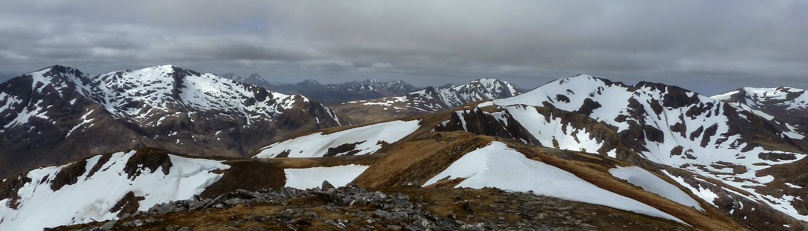
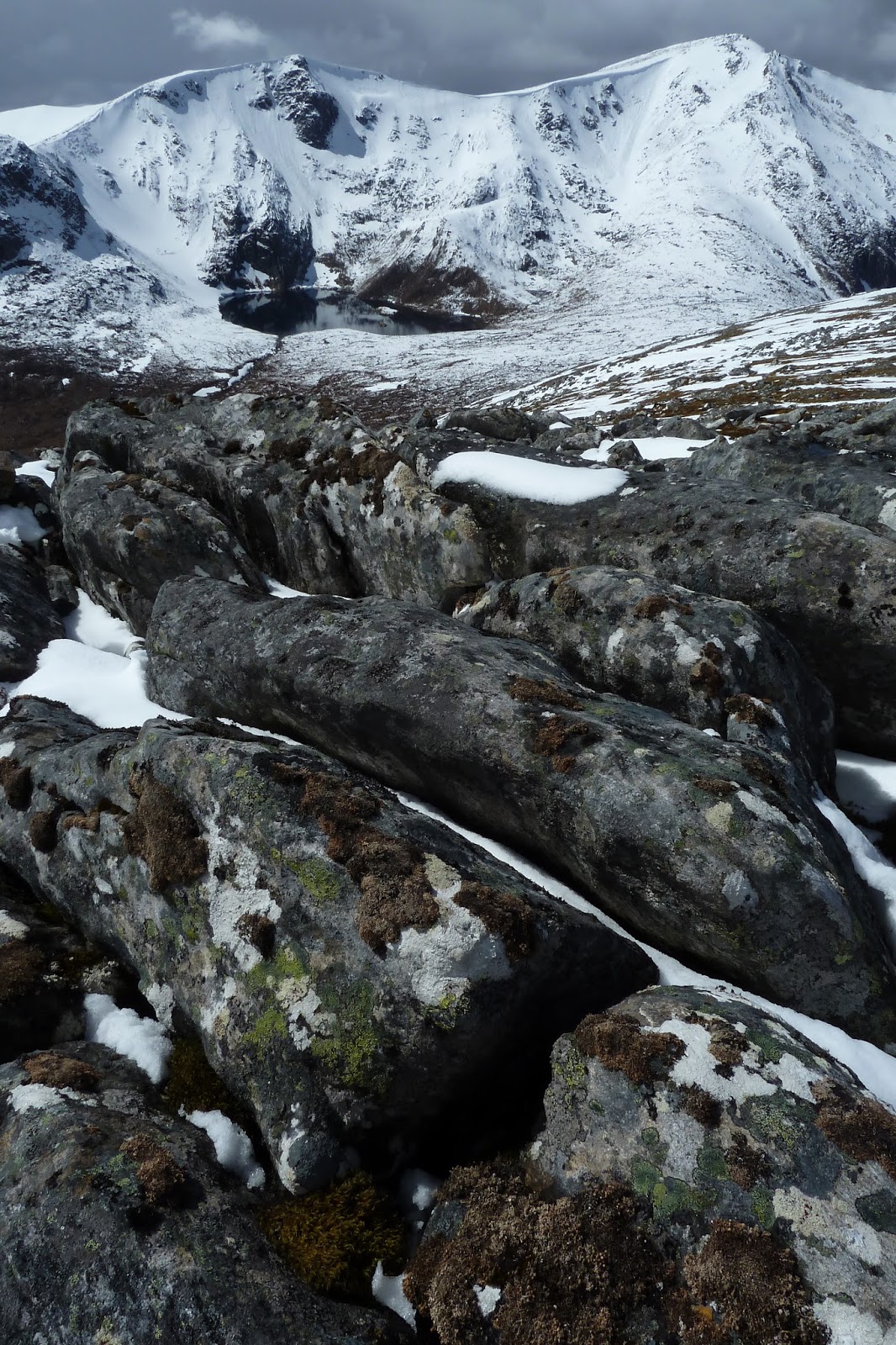
In the afternoon we set out to climb Carn nan Gobhar. After a tussle with peat hags clogged with the remains of an ancient forest that must once have covered the slopes, we pulled up onto the broad back of the mountain. We were amazed in places to now be plodding through 20 to 30cm of fresh snow. We saw a weather front coming over the hills to the west and it arrived just before the top, engulfing us in a whiteout. Luckily it cleared quickly and we continued to the top to enjoy a breathtaking view of the adjacent peak, Sgurr na Lapaich, and its achingly beautiful coire lochan.


We weren't so lucky with weather the next day and turned back from our peak in rain and sleet and winds that blew plumes of spindrift from the ridges. The bonus at least was the chance to have a low-level wander in the afternoon to explore the old, atmospheric pines of lnchvuilt Wood.

Our last sortie from basecamp saw us climb two Munros, Sgurr na Ruaidhe and, confusingly, a second Carn nan Gobhar. They were only lightly touched by snow but blasted by freezing cold northwesterly winds. Sgurr na Ruaidhe in particular seemed to be placed at some sort of vortex and we crouched behind the modest cairn for a modicum of shelter. It was hard to believe that at the end of May we were dressed in wool layers, duvet jackets, thick gloves and waterproofs to try to keep warm. Even the ptarmigan who spend all winter up here in the snows were escaping the wind in their shallow snow holes.


With three Strathfarrar peaks in the bag, we packed basecamp away into our backpacks and barbags and made the long cycle back down the glen. Our wee basecamp had provided supplies and shelter though it failed on communications as the only smartphone signal was on the tops of the Munros. In the few days there, we'd explored and climbed mountains but the only hunting done was to find the last packet of biscuits at the bottom of the basecamp food bag.


Fact File
More photos: click HERE.
Access: Glen Strathfarrar is accessed from Struy, north of Cannich. Access to the glen is restricted for motor vehicles but fully open for walkers and cyclists. The private road is asphalted throughout.
Our route for Carn nan Gobhar (Mullardoch): At the very end of the asphalt road we crossed the river by the small dam at the power station marked on the map at NG183381. Climbed the steep hillside above through thin birch woods and struck out SSE to gain the ridge between Carn nan Gobhar and Creag Dubh then walked to the top. Headed slightly north then descended west to the bealach between it and Sgurr na Lapaich.  From here descended into Garbh Coire to eventually pick up our outward route. This route is mostly quite rough with no paths except at the bealach.
Our route for Sgurr na Ruaidhe and Carn nan Gobhar (Strathfarrar): A track leaves the road at NG284386. We followed it (boggy) until we could gain the ridge of Sgurr na Ruaidhe where there's a bit of a path. From the top headed NW to the bealach bewteen it and Carn nan Gobhar where the route is clear to the second top passing a boulder field that was a bit annoying in soft snow. We descended SW to the next bealach then south into Coire Mhuillidh (rough and boggy) to eventually pick up our outward path.


Wednesday 27 May 2015

Glen Shiel - Perfect 10

Glen Shiel is a narrow valley in the northwest Highlands that cuts a line through rugged mountains to drop to Scotland's west coast at Loch Duich, a long finger of sea reaching far into the hills. After rain, which is often, the steep hills and gullies weep water in hundreds of streams and waterfalls that coalesce into foaming white torrents in the lower glen. The north and south sides of the glen are bounded by high, narrow ridges that string together a mouth-watering array of Munros, Scottish mountains over 3000 feet. For some time I'd been wanting to do a circuit of the glen, walking out along one ridge, making a high camp in the mountains and then returning next day along the other ridge. A two-day window of good weather in an otherwise wet and windy holiday week with Bart provided the opportunity.

Day One -  South Glen Shiel Ridge, seven Munros, 16 miles, 5971 feet of ascent
We set out early morning along the old Tomdoun road from the Cluanie Inn. It doesn't reach Tomdoun these days having been drowned by the hydroelectric schemes of Glen Garry. We eventually left the old road and picked up a wynding stalker's path that took us up onto the ridge and the first Munro of the day, Creag a Mhaim. A huge walk stretched out ahead of us through a jumble of peaks and a maze of ridges. There was a lot of lingering snow in the coires and gullies but the ridge itself was mostly clear.  We headed west under grey skies, collecting more Munros with the passing miles. About halfway along, after the peak of Aonach Air Chrith, we came to the narrowest section of the ridge  and picked our way carefully along the top of a thin fin of rock above sheer cliffs that plunged to the coire below.


By late afternoon, the sun had finally broken through and the grey skies had cleared to blue as we clambered up the final Munro at the west end of the ridge, Creag nan Damh. It was the lowest peak of the day but the only one holding onto snow on the top itself. With seven Munros in the bag, we dropped off the ridge and followed a river downstream. It cascaded in a spectacular plume of water over tall cliffs and just below here we made our camp for the night. The sun dropped quickly behind the high peaks and it was soon cold. The temperature, or perhaps the day's exersions, forced us early into our sleeping bags.


Day Two - Brothers' Ridge, three Munros, 7 miles, 4450 feet of ascent
The second day of our mini adventure didn't get off to a perfect start when we got tangled up in steep forestry as we crossed the floor of the glen and then missed the route of a path up onto the ridge. The north side of Glen Shiel is precipitously steep and we found ourselves clambering up grass slopes where a dropped orange would have rolled all the way to the valley bottom. But once on the ridge, the day ahead was pure mountain joy in sunshine and blue skies with spectacular views of the neighbouring peaks, the Five Sisters of Kintail.


The route was again narrow in some places and the top of the second Munro, Sgurr a Bhealaich Dheirg, was strung out at the end of a skinny rock ridge that made a delightful airy stroll. The third Munro on the Brothers' Ridge, and the last of our trip, was a slightly disappointing lump of a peak but we sat there a while in warm sunshine until a chill wind chased us off the top. Back down in the glen, we found the faint line of the old military road that once ran through Glen Shiel, connecting Fort Augustus with barracks at Glenelg.  It pleasantly covered the final miles back to our start point at Cluanie Inn where we had cold drinks sitting in the sun, content in the knowledge that we'd climbed ten new Munros.


Fact File
More photos - click HERE.
Start/finish - Cluanie Inn, Glen Shiel where the Fort William/Skye bus drops and picks up.
Map: OS Landranger 33
Route: Take the private road that heads south about 300m east of Cluanie Inn. Just as the road begins to drop to Glen Loyne a path leaves on the right. It soon splits - take the right hand split. This path zig-zags up to the first Munro on the ridge, Creag a Mhaim. The route west along the ridge is obvious in clear weather with a good path all the way. There are a couple of narrow sections on the ridge. For the second of these, as above, you need a bit of a head for heights although the exposure is minimal. After the last Munro on the ridge, Creag nan Damh, we returned to the bealach just before it and descended into Am Fraoch-choire, staying well on the east side of the river to avoid cliffs and then crossing easily at the bottom of the waterfall. From here there is a clear path and we camped a little further down beside the river. Next day we continued down the path. When it reaches forestry, it's better to walk on the east boundary of the forestry than to go through the middle. We then joined the main road in the glen, the A87, and walked east for 1.5km to a small layby on the north side where a path up to the north side ridge is signposted. At some point above the forestry we missed a faint split and ended up joining the ridge further west than planned. Once on the ridge, the route east across the Munros is again obvious with a good path. We came off our final Munro, Aonach Meadhoin, via its south ridge. Once down in the valley we picked up the old military road east of the forestry here which provided a good walking route back to the Cluanie Inn.
Tip: If camping is not your thing, you could do this route starting at the west end and stay at the Cluanie Inn overnight.


Saturday 16 May 2015

Creag Meaghaid - A little bit of Arctic in my life

For a sliver of a moment I could have imagined I was in the Arctic. Looking south across the snow-covered plateau all I could see was pancake-flat snow and a cloud-clogged sky. Behind me was a trail of fresh footprints in powder snow and ahead a fin of wind-sculpted snow led to the summit. In the distance was a range of rocky, snow-streaked peaks.  For a fleeting moment the landscape was bathed in a magical northern light as sun burst through the clouds, illuminating the plateau and creating shadows and contrasts on the glistening snow.

Of course, this place wasn't the Arctic. It was Creag Meaghaid in May, still clutching onto its winter snows. Bart and I had climbed up from Aberarder. A long trail through springtime birch woods had gradually been enclosed by steepening mountain walls until it entered the spectacular amphitheatre of Coire Ardair. Cliffs of broken black rock gashed by snow-filled gullies plunged to the sparkling waters of the lochan below. The only exit from the coire was a steep, snow-filled notch called the Window. We climbed up, kicking steps into the snow, and gazed through to a winter world of snow-covered high moors and overhanging cornices the size of big surf waves. A short pull up from here had taken as onto the Arctic-like plateau of Creag Meaghaid.

After we'd soaked up the views and atmosphere, we returned to the Window and walked east along a high ridge, happily adding another two peaks to the day's tally. As we approached the last peak of the day, a tiny piece of Creag Meagaidh's Arctic chased us to the top as the west wind blew in the lightest flurry of snowflakes.


Fact File
Start/finish: Aberarder at the nature reserve car park.
Map: OS Landranger 34
Route: Follow the main trail from the car park towards the park buildings where it passes to the right. Stay on the obvious trail for 5km to the lochan in Coire Ardair which is a fine day walk in itself. From the lochan the Window is an obvious notch to the northwest. It's a steep climb on snow at this time of year. From the Window head south and then west across the plateau to the summit which sits a little higher at the far west. We returned to the Window and continued east along the ridge taking in another two Munros, Stob Poite Coire Ardair and Carn Liath. We descended the south ridge of Carn Liath, eventually picking up a rough path that rejoined the main trail about 1km above the park buildings.

Saturday 2 May 2015

Arrochar Alps - Yesterday's peak

Most mountains go uphill but some go more uphill than others. Ben Vane and Ben Vorlich are two very uphill mountains sitting side-by-side in the Arrochar Alps. Most people that climb these mountains do so from Inveruglas on the banks of Loch Lomond because most people arrive by car. But I'd recommend a different way.

Take the evening Mallaig train out of Glasgow and after it's chugged up Loch Long under the dramatic rock peak of the Cobbler, jump off at the stop for Arrochar and Tarbet. Make a long walk in through the quiet valley of Glen Loin where the dusktime woods are alive with evening song and the gorse smells of coconuts. Pitch your tent at the head of the glen on the edge of the wood beside a wooden bridge over a tinkling stream and fall asleep to the hoots of owls.

Next morning follow the narrow trail north as it climbs through a rugged landscape of rocky knolls and thin birch woods. You might see a skein of northbound geese overhead, their underwings reflecting the morning sun so they shimmer in the blue like a shoal of fish. Your trail will eventually join the hydro road up to the dam. Enjoy its flatness for a little while before the steep pull up Ben Vane. You'll need your hands at one point and maybe an axe and spikes. There's a pesky slope of late spring snow on the final steep climb with a 200m vertical drop. At the top the view is open and airy and the pointed peak of Ben Lomond draws the eye south.

Once you're back down there's a great camp spot where the Allt Coiregrogain meanders gently down through the woods in little waterfalls and deep pools. It's a satisfying place where you can make an afternoon cuppa and sip it while looking back up at your mountain.

As you've camped high in the hills you can make an early start tomorrow up the steep path to Ben Vorlich.  It doesn't hang around, it just goes straight up the vertical flank of the mountain. The reward for slogging up is a pleasant high level stroll along the top and a dreamy view down Loch Lomond. Low, humpbacked islands float like a lazy pod of whales in water that's as thick and silvery as mercury.

But the nicest thing about these two mountains is their neighbourliness. When you're on the top of Ben Vane you can look across at tomorrow's climb. And when you've done tomorrow's climb and you're on the top of Ben Vorlich, you can look back at yesterday's peak.


Fact file
Start: Arrochar and Tarbet Railway Station served by Glasgow to Oban and Mallaig trains.
Finish: Inveruglas served by Glasgow to Fort William Citylink buses.
Map: OS Landranger 56
Route: At the bottom of the stairs that exit the platform at Arrochar and Tarbet station turn right and you're immediately on a lovely woodland path that contours round Cruach Tairbeirt. It passes above the village of Arrochar with views down Loch Long and across its waters to the more southerly peaks of the Arrochar Alps. Don't take the path that spurs into the village but keep going north on the main trail into Glen Loin signed for Inveruglas. There's a nice flat grassy camp spot just before the path climbs to go over a small pass. On the other side of the pass the path descends to the farm at Coiregrogain. Cross the bridge over the river, go up to the tarmac hydro road and turn left. Turn left again at the next bridge and cross it. After 500m a small stream comes down from the right and there's a stone parapet on the track. There's a faint path here which is the start of the route up Ben Vane. There's a steep but easy to follow path to the top. At one point there's a tricky step up rocks but a route to the right is easier. I returned via the same route and when I reached the track turned right and camped in the forestry by the river about another l.5km further on. It was a nice spot.
For Ben Vorlich return to the hydro road and turn left. After about lkm there's a small cairn at the side of the road that marks the start of a path up. It's a steep slog that becomes more interesting higher up and finishes with a pleasant stroll to the top. At the south end of the ridge the views down Loch Lomond are superb. Return via the same route and to walk out to Inveruglas just keep on the hydro road down to the A82 and under the railway line. A footpath to the left then takes you safely to the Sloy power station and a wee visitor centre with a cafe were you can pass time as well as water until the bus comes. The bus picks up opposite the power station if you wave your trekking poles at it frantically.