Sunday 27 December 2020

Trossachs - An alternative Christmas

With the COVID travel restrictions eased for Christmas Day and my decision made to not mix with other households, an alternative Christmas beckoned in the hills, especially as tighter restrictions were moving in from Boxing Day. So my extended household and I headed to the Trossachs. 

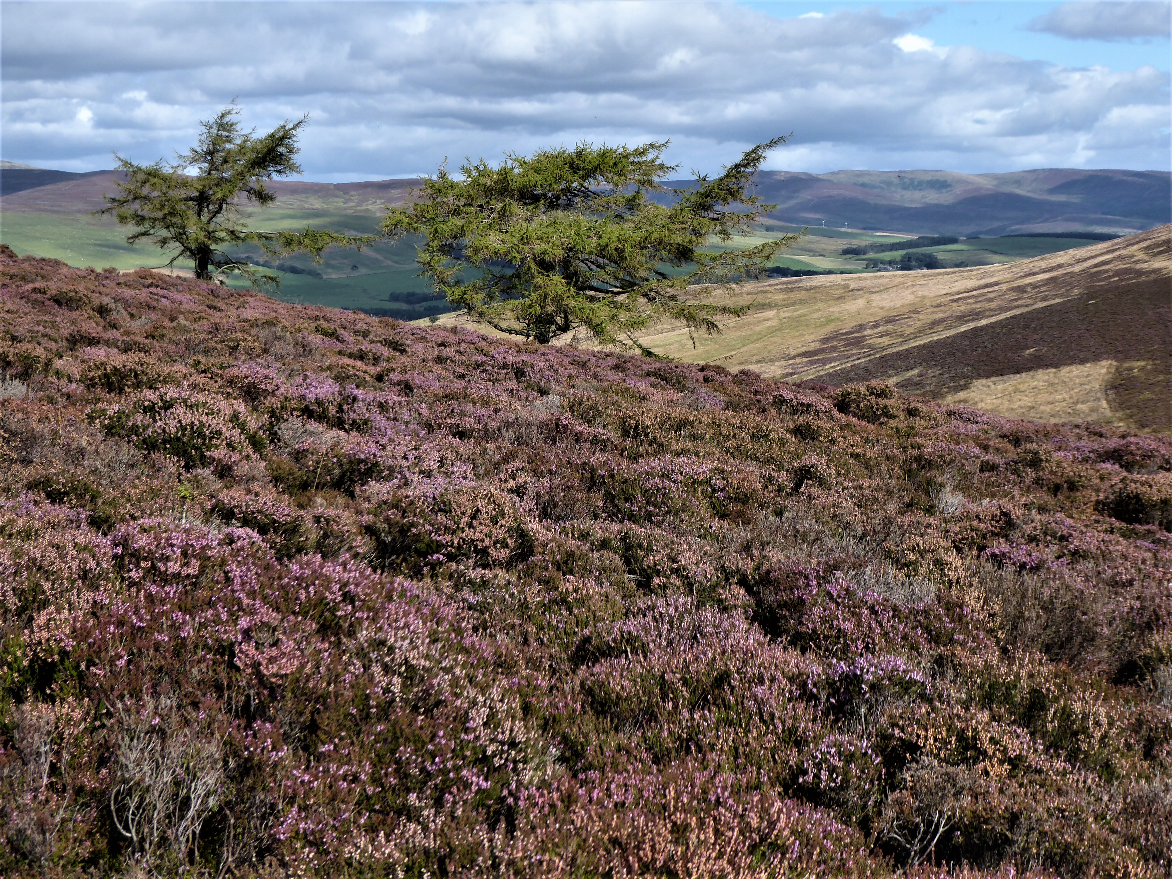
We arrived into a cold, grey day with a ceiling of low cloud that blocked out the sun and kept the day in a perpetual twilight, so characteristic of this time of year. Throughout our walk showers of fine rain would gather in the west around the slopes of Ben Venue then sweep east across the valley, soaking our jackets, trousers and rucksacks but leaving sparkling beads of water on tree twigs. As the weather shifted at moments, huge banks of dense, white mist billowed up the valley like a slow-moving avalanche and we watched it, mesmerised. But splashes of colour were added to this dreich day by the birch trees and the withered bracken. Of course, this is the kind of day I love when the elements are all around me.

Our walk climbed steeply from the shore of Loch Vennachar on a path that was heavily iced up. This was welcome because the wet second half of the year has turned everywhere to bog but the frozen ground was much easier to walk on. Mind you, there were still some pockets of unfrozen ground and it was impossible to tell until you stepped onto the boggy bits if they were frozen and would hold your weight. On this icy path, we ascended up through beautiful oak and birch woods, eventually popping out above the trees into what felt like a secret world, hidden up in the mist.


Our route made a high traverse west next, through a pleasant landscape of heathery knolls, to eventually emerge above Glen Finglas. The sun very briefly broke through the clouds here and illuminated the woods that carpeted the hillside, bringing out the purple and orange hues of the winter trees. Two deer ran by and a snipe exploded from the undergrowth. We dropped down the hill now to briefly pick up the glen road and walk by the cottages that we’d seen from the hill above. Their chimneys puffed smoke from cosy fires inside. 


A network of trails took us back through the woods and to the water’s edge at Loch Vennachar. We walked through Little Druim Wood on the way which was dotted with art sculptures including a beautiful deer whose open metal structure seemed to emerge from the forest itself. 

At the loch shore, I pitched the outer cover of one of my tents to make a shelter from the rain and laid out a groundsheet for sitting on. Here we watched what daylight there was fade into night. The geese out on the water were the only sound that drifted to us as we cooked a Christmas dinner on our camp stoves – soup with bread, curry with rice and tea with Christmas cake. 

Then it was time to pack up and walk back through the night-time woods. 

Fact File
Start/finish: Woodlands Trust visitor centre Glen Finglas near Brig o'Turk
Public transport: In normal times and not on Christmas Day, I take a bus from Stirling to Callander and use the Great Trossachs Path to reach Glen Finglas.
Route: Centre is closed currently due to Covid but there are numerous paths and routes in the area detailed on noticeboards outside or here
.

Sunday 13 December 2020

Hillwalking for the non car owner

A few weeks ago I was interviewed virtually by one of Scotland's best known outdoor writers who goes under the name Munro Moonwalker. A chance comment by me on his Facebook page about accessing the hills without a car seemed to strike a chord and he made contact for more information about my experiences. I've never owned a car so all my solo hillwalking and cycling trips are done by public transport. Even the majority of trips with friends will use buses and trains as we find this much more enjoyable. I originally replicated on my own blog the answers I collated, especially as they didn't all appear in the article. However, I've since agreed that the information I provided can be used for an article in the Munro Society Journal. So I'll just give a flavour in this blog and include some of my photos that I submitted to accompany the material.

My most important reason for never owning a car and using boot, bike, bus and train to get around is an environmental one. The main source of air pollution in this country is transport and the majority of vehicles emitting that pollution are individual cars. All that pollution contributes to ill health and climate change. Public transport is still associated with emissions of course but it's a more efficient way of moving people around. The huge volume of cars on our roads now is also the main reason people quote for not travelling actively by bicycle or walking, so it's a double whammy for poor health. Supporting rural train and bus services is important as well to ensure they are kept running for those who depend on them.

The other reason for not owning a car is simply that I enjoy life so much without one. In terms of hillwalking, it can be challenging getting to some hills by public transport or bicycle but this makes things more rewarding and forces you to be creative in how you go about things. I think it also improves your planning and risk assessments as there is no easy escape home if a storm is moving in and the last bus has left. Likewise, you don't have the security of a car at the bottom of the hill. The train especially is such a relaxing way to travel as you can chat with friends or watch the scenery and enjoy a cup of tea from the trolley service. The bus is great for wherever the train doesn't reach and bus drivers can be really helpful about dropping you right at the start of a walk. Both of these open up great possibilities for through routes, where you start and finish at different places because you don't have to get back to wherever you've parked a car.

Overall, it just feels the right thing to do and I believe I'm happier and healthier for not owning a car.

Corrour Station: a favourite spot for jumping off the train in the middle of the hills.

Drumochter: I climbed the Drumochter Munros using the train to Dalwhinnie then the folding bike to bridge the gap between the train station and the start of the walk.


Achnashellach is another favourite station that gives good access to Torridon to the north or the Monar Munros to the south.

Caledonian Canal: I used the canal towpath and a kick scooter to get form the train at Banavie to the Loch Lochy Munros.

Sunday 29 November 2020

Argyll - Essential travel

Before the COVID tier system came into place, I'd a reason to do some essential travel to support a friend at an important work event. I took the opportunity to get an earlier train there and grab some time outside, using the West Highland Way to walk from the station at Bridge of Orchy through to Kingshouse. It was a beautiful autumn day for it and the hill colours were at their fiery finest.

From Bridge of Orchy the route ascended to the pass of Mam Carraig which opened up the view to the sweeping lines of the peaks and ridges that culminate in Ben Starav. 

From this high point, the path dropped down to Inveroran. I loved the message board outside the hotel here where folk who had passed on the West Highland Way this year had scribbled their names. The route leaves Inveroran to climb up onto Rannoch Moor, heading north on the old parliamentary road.

Up on the moor, the colours were ablaze in the autumn sunshine with russets and golds that contrasted with blue skies and grey rock. I love striking out across the moor here. It feels wide open and empty. 


The only feature that the path crosses is Ba Bridge which takes it over the rocky gorge of the Ba River. Today birch trees that were clustered around the bridge added gold and purple to the pallet.


The sun was starting to sink now and the Black Mount peaks cast their shadows across the moor. I'd planned to be out late though, to finish the walk after dark. So I climbed higher onto the older military road, which was marked by a crumbling stone cairn. With big views, this was a great spot to watch the sun set. As it did so, shafts of light illuminated patches of hillside in turn and the lochans studded across the moor appeared alight, as they reflected the orange glow of the hills.

There was just enough light left in the day to bring me down to Kingshouse without a headtorch. Waiting there was my friend, a pot of tea and a nice surprise - we'd been upgraded for free from the bunkhouse to a swanky room.

Fact file
More photos HERE
Start: Bridge of Orchy
Finish: Kingshouse Hotel
Public transport: Citylink buses and West Highland line trains for Bridge of Orchy; Citylink buses for Kingshouse.
Route: Exit the station at Bridge of Orchy down the stairs and turn left at the bottom. This is now the West Highland Way and well signed through to Kingshouse. 

Saturday 14 November 2020

Dava Way - Delayed departure

The Dava Way is a walking and biking route that uses the line of the old Highland Railway between Grantown-on-Spey and Forres. It passes high over heather moors and open hills but it’s also bookended by beautiful, autumn woods. As it’s only 24 miles long, we thought there’d be no trouble in delaying our departure from Grantown on our bikes to let morning rain pass. We were so sure that we would easily make it to Forres before dark. But we were wrong!

The route started well enough out of Grantown, cycling through the woods to climb up onto the moor. But we were soon bogged down in mud, courtesy of the recent wet weather, and progress with loaded bikes was extremely slow. Luckily, there was plenty to divert our attention. 

A few miles into the route, the trail passed above Huntly’s Cave ravine, a dramatic cut in the landscape that was almost hidden by dense trees. Above the ravine is Carn-na-Croiche, also known as the Hanging Hill. In the 17th and 18th centuries cattle reiving was rife and Huntly’s Cave ravine was an excellent spot to ambush reivers as they returned to Lochaber and Badenoch with their booty. Those caught here were hung on the Hanging Hill gallows.

Leaving this gruesome tale behind, we cycled up onto the open moor and the highest point of the route. We saw nobody up here and it really felt quite remote. Our trail was crossed by another track which headed out over the hills following a route used in 1690 by a party of Government foot-soldiers. They were heading over to Cromdale to suppress a Jacobite army that had encamped there the previous evening. Despite having to ford the River Spey, they won the battle which held back the Jacobite uprising in the Highlands for another 25 years.

In some places, the track was firmer and we made some progress but in other places the chunky ballast, left over from when the line was in use, slowed us even more than the mud. But we loved being out in the hills on our bikes and were reminded how high we were as we cycled into Heatherbell Cutting. The cutting was the site of many line blockages due to snow and this led the railway company to build its first snowploughs. In 1963, a southbound train out of Forres was derailed here in deep snow. Engines sent to assist ended up being stuck for two weeks in the drifts. Nobody was hurt and the passengers eventually made it back to Forres.

Beyond Heatherbell Cutting, we skirted around the edges of a small hill called Knock of Braemory. At the foot of the hill, we pulled into the Halfway Hut. There was a clue in the name that we were way behind schedule! It was clear at this point that we wouldn’t make it to Forres before dark, especially with the early nights of late October. The Halfway Hut is a former linesman's hut and has been renovated for folk to use for a lunch stop or to get out of bad weather. It had plenty of charm with a solar panel powering fairy lights, so we lingered a while inside enjoying some snacks before getting back on the bikes.

As we descended, we passed into a pleasant landscape of woods and pastures, punctuated with the vibrant golds and russets of autumn colours in the trees and the bracken. Before too long, I found among the pines probably the only dry bit of ground for pitching the tents while Graham found a mains supplied tank at the edge of a field that provided water for drinking and cooking. So that was us sorted for a pleasant evening camping in the woods. Unseen birds twittered in the canopy above and gentle rain showered the tents at some point in the night. 

Next day, we cycled the final section of the Dava Way into Forres. It was stunning in places as the track passed through autumn birch woods, their leaves blowing on the breeze like golden confetti. At Forres we turned around but ours was not a return ticket for the Dava Way. Instead, we took a quiet hill road back to Speyside. 


Fact File
More photos on Flickr
Start/finish: Grantown-on-Spey
Public transport: Train to Aviemore then NCN7 to Boat of Garten then quiet back road to Grantown. Or train to Forres and start there.
Route: Dava Way starts behind the campsite in Grantown and signed from the road that passes the campsite. To return we took the B road then unclassified road to Knockando via Dallas. From Knockando used a bit of the Speyside Way back to Grantown but it was also very muddy so we ended up mostly using the B road on the north side of the Spey which was actually very pretty.


Saturday 31 October 2020

Lomond Hills - Covidiscovery

We might not have imagined back in March that coronavirus would still be impacting on our lives in October but many restrictions remain in place and new ones are on the horizon. I’m still not gallivanting all over the place as I did in normal times, especially as I'm dependent on public transport to get further afield. Instead, I’m limiting my travel and still staying mostly quite local. One local trip that had been staring me in the face for some time (literally, as I look at these peaks every day from Portobello) is a traverse of the Lomond Hills with an overnight camp. Although I’d walked East and West Lomond hills many times, I’d never really explored much beyond that, so now was the perfect opportunity.

Walking through the housing estates of Glenrothes may seem like an odd way to start a hillwalking trip but that was my route from the train station in Markinch to the bottom of a woodland path at Pitcairn, on the northern edge of town. I’d not used this path before and it was lovely as it wound its way up through autumn woods to East Lomond. Thick mist and drizzle hung low above the trees and created a grey, clagged in kind of day. There was no view from the top of East Lomond but I loved the atmosphere the dreich weather created which imparted a wilder feel to these gentle hills.

Dropping off the far side of East Lomond and exploring beyond the usual path to West Lomond was a great covidiscovery! The two hills sit on top of a shelf of raised land and here were woods, reservoirs, farms and a network of trails.  As I dropped down, the surrounding towns were obscured and the wild atmosphere was enhanced. I wandered happily for hours, eventually picking up a track that used a wide ride through the trees to reach the farm at West Feal. 


From here, another trail climbed up the gentle side of Bishop Hill to eventually reveal its more precipitous west face. This was my planned camp spot for the night. Bishop Hill is less prominent than East or West Lomond but its long north-south ridge forms the steep eastern boundary of Loch Leven, so the views over the loch are superb. I pitched the tent on the ridge as the evening sun broke free of the clouds and sank beyond the Ochil Hills which straggled westwards towards Stirling.

Next morning, I packed up early and headed north along the remainder of the ridge of Bishop Hill. A grainy, grey light bathed these local hills but further north the twin peaks of Ben Vorlich and Stuc a’Chroin were ablaze in pink and orange. Eventually, at the far end of the ridge, I popped down into Glen Vale, whose sudden, deep depths were quite a surprise. Over the millenia, a chasm has been carved out by water, exposing sandstone rock faces that were laid down 350-400 million years ago. One of the rock features is known as John Knox’s Pulpit as the 16th century religious reformer was known to have visited Glen Vale.

Leaving Glen Vale, I followed a vague path across fields of sheep to eventually pick up the trail that encircles Loch Leven. I followed the loch shore round to the RSPB centre on its southern edge and climbed the path up Benarty Hill which is also known as the Sleeping Giant. When seen from the north, the profile of the hill looks like a huge warrior in battle headdress lying on his back. I imagined that, like me, he was gazing up to a blue sky scored with straggly skeins of geese.

Dropping down the steep path on the south side of Benarty Hill took me to a trail through the beautiful autumn woods of Harran Hill. This in turn connected me to Lochore Meadows and a short final walk on the pavement to Lochgelly for a train home. This had been a modest trip, not very far and over small hills but I’d loved connecting it up by train, finding wildness close to home and discovering lots of new routes and places.

Fact File

Start: Markinch train station

Finish:Lochgelly train station

Photos: Flickr

Route: Followed the main street west out of Markinch, right at the roundabout then left along Cadham Road, right on Western Avenue, left up Pitcairn Avenue, right on Tanna Drive then left up Moidart Drive to the Pitcairn Centre. There are lots of trails around here so I had the Walkhighlands description of the to route to East Lomond handy. From East Lomond took the main path west to Craigmead, turned left on the road then the first track to the right passed Little Ballo. A path leaves this track and passes alongside the dam of Harperleas Reservoir. At the far side turned right along a track on the south shore of the reservoir. A path leaves this track signed for West Feal then turned right when it joined the track to the farm. Passes behind the farm buildings on the righthand side then climbs to Bishop Hill. Continued north along Bishop Hill then followed a path that dropped to the east to join the main route through Glen Vale. Stayed on the south side of the burn and the path passes into sheep fields before the first dirt track to the right which joins the unclassified road at Glenlomond. Walked to Wester Balgeddie then turned right on the A911 to Loch Leven's Larder - a lovely shop/cafe where there is also a path down to the Loch Leven Heritage Trail (follow the cycle signs). Followed the loch trail to the RSPB at Vane Farm and took the path out of the other side of the centre that goes to Ballingry. At the top of the climb joined the ridge of Benarty Hill. From the trig point a path heads southeast and joins the unclassified road from Ballingry to Lochran. Immediately opposite, took the track and then the path signed through Harran Hill. Walked to Crosshill through Lochore Meadows Country Park and then up to Lochgelly.

Info: Also, in normal times, a nice coffee shop at the RSPB centre with panoramic windows looking over the loch. 


Saturday 17 October 2020

Gear Review - Outdoor Research Alpine Bivy

When I first started camping nearly 30 years ago, the first shelter I bought was a double-hooped bivy bag. It was quite the thing at the time and a lot more lightweight than the tents available in those days. For somebody of my size, it was also quite spacious and, at a push, I could get changed inside in bad weather. In time however, tents became incredibly lightweight so that it was much more appealing to have room and space to cook in bad weather for the same weight penalty as a bivy bag. Therefore, for most of the years since then, I've used a lightweight one-person tent for camping.


A couple of years ago, for whatever reason, I decided to get a bivy bag again. The modern versions do represent a weight saving relative to a tent and also pack smaller, which is something I'm keen on for fitting on my handlebars on the bike. I bought it with the idea that it would never replace the tent but that it would be good for some trips, such as single overnight routes, when you can be sure the weather will be dry - there's no cover for cooking, changing or packing if it's raining. The other aspect of the bivy that I like is that it's a different experience to using a tent. You are not zipped away inside all evening so the feeling is one of being much more "outside". It's also more discreet, takes up hardly any space and you can pretty much roll it out anywhere. As well as this, its low profile is better in high wind than a tent.

I bought the Outdoor Research Alpine bivy which cost £245 at the time from Ultralight Outdoor gear. It has a goretex upper and a ripstop nylon base, both waterproof. It's a single hoop bivy so it has a pole at the entrance which generates a feeling of some space at the head end.  It can also be used without the pole. The opening is clam shell style and can be zipped closed or left open with or without the integrated bug mesh. A couple of clasps hold the door up out of the way for entering and exiting. There's a loop at the top of the entrance for adding a single guyline which better supports the pole. If I remember correctly, the guyline wasn't included and I added this myself. A small loop at each end allows the bivy to be pegged down as well. On my scales the total weight including bivy, stuff sac, pole and guyline is 599g.

When I set the bivy up, I stash my panniers or rucsack down at the bottom end and this gives it a bit more structure along the whole bag. I carry an extra waterproof bag for them in case they are wet from rain. Of course, I can do this and still get inside with room to spare because I'm a little over 5 feet. At the top end, inside the lower half of the clam shell opening, I keep my shoes and other things I want to have handy. 

I've mostly slept with the door open but the bug net pulled across. It feels a little claustrophobic otherwise and you are also faced with a confusing array zips should you close them all. Of course, you should never zip it closed completely but always leave a small gap for air. I find leaving the door open allows the bag to be well aired and I've not had a problem with condensation other then when a thick mist was blown inside due to a change in the wind direction. As my plan was always to use it for short trips in good weather, I don't expect to test it in bad weather. I've had one night using it when it rained briefly. I scrunched up the lower half of the opening into the bivy and, as the upper door creates a small overhang, this kept everything dry. Again, I had space to do this because I'm very small.

I'm quite happy with the bivy but I've not used it enough to have an idea of its durability. I love it for short, quick, overnight trips when a tent seems such a faff. The only thing I'm not sure about it is how to spell it .... bivy, bivvy or bivi!

Saturday 26 September 2020

Blairadam - Brief blurb about a bite-sized bivvy break by bicycle

It would be fair to say that I’m not very talented but I am good at one thing at least and that's hunting out the best wild camping spots. Often, you can look at a map to guess a good spot and other times, you just follow your nose to find one. In the hills or more quiet parts of Scotland, it’s not difficult at all to find good wild camp spots but in the central belt, which is largely towns and farmland, it can be much more tricky. In these places, I often look for patches of forestry which have paths or tracks leading into them. These almost always offer up a spot and provide some cover as well.

You don’t always get a good view in the woods of course, so I wasn’t expecting much as I pulled into Blairadam Forest in Fife late one day looking to camp. Scanning the map beforehand, I had spotted that a track ran close to the edge of the forestry on Cowden Hill. I wondered if it might provide a pitch that was a bit more open. I cycled through the forest then investigated a more faint track towards the edge of the hill. Sure enough, it yielded a beautiful bivvy spot.

Here on the flank of Cowden Hill was a flat shelf of grass beside the remains of an old wall which provided some shelter from the chill, autumn wind. So I unloaded my bike and rolled out my bivvy bag. A steep field bounded by broadleaf trees fell away in front of me to the farmhouses below. So sharp was the drop that house martins swooped past at my eye level. At dusk, I loved watching the farmhouse lights come on in the windows which emanated a cosy glow. The rest of the forest stretched out behind me and echoed with hooting owls. But it was the bigger view from my bivvy that was quite wonderful as it looked over to Loch Leven. The rugged peaks of the Lomond Hills were the backdrop to the loch and the foreground was filled by the sweeping lines of the north slope of Benarty Hill. When it was fully dark the streetlights of Kinnesswood, on the far side of the loch, created a cluster of orange lights that crept up the slopes of Bishop Hill. Down below, the headlights of vehicles on the motorway passed noiselessly back and forward. What a great spot!

It was a joy to find the place after a day of cycling on this mini tour close to home. I had taken a short train ride to Dunfermline then pedalled along the West Fife Cycleway to Alloa. From here I picked up the Devon Way to Dollar. It was a dream cycling so far on these traffic free routes. Both are lined by trees for much of their way so you tend to lose track of exactly where you are. But when the route opened up a little, I had views over farmland to the River Forth and eventually to the steep flanks of the Ochil Hills.

From Dollar, there was an enjoyable network of tiny farm roads that linked up to take me to Cleish. The only disadvantage of these roads, especially at harvest time, is that you are likely to meet a huge tractor at some point with no room to pass! From Cleish, I made the steep cycle up the Nivinsgton Road, passing through Nivinsgton Crags. I’ve discovered this road quite recently for cycling and have quickly grown to love it. It’s steep but can be ridden even with a loaded bicycle. At the top there are expansive views over the quaint patchwork of farms which is juxtapositioned with the wildness of the loch and hills. At the top of the climb, I turned onto the dirt trails that criss-cross Blairadam Forest to source my bivvy spot for the night.

I'd brief company after supper when two mountain bikers stopped by. They were  friendly, local lads from Dunfermline and Milnathort, and wished me a good evening before heading off. It was peaceful thereafter. Droplets of water on the bivvy in the morning indicated that there must have been a shower of rain overnight but I'd slept well and was unaware. I'd planned a very short second day to get home ahead of a big storm. The wind was already picking up as I packed up, so I cycled down to Loch Ore to make breakfast. The wind whipped up the surface of the water here but the shrubbery provided a bit of shelter to make some hot coffee and porridge. From Loch Ore, a couple of miles of cycling took me to the nearest station for a train ride home to end my bite-sized break.

Fact File
More photos incl stuff on the old railway lines Here
Start: Dunfermline
Finish: Lochgelly
Public transport: Train to Dunfermline Town station; 
train back from Lochgelly station.
Route: West Fife Cycleway/National Cycle Route 764 from Dunfermline to Alloa which links to the Devon Way to Dollar. Out of Dollar took the hill road which goes round the back of Law Hill. This allowed me to avoid the A91. Where it met the A91, I turned right then a quick left towards Rumbling Bridge. Straight over the A823 for a back road to Crook of Devon. The unclassified roads to the south and east of Crook of Devon link up to Cleish to avoid the B9097 which is quite busy. Took first right after Cleish to climb the Nivingston Road then the track into the forest on the left at the top of the climb. Exited Blairadam via the Maryburgh path which I would avoid in future as there were four locked gates to get the bike over and a lot of mud and cowpats. At Maryburgh turned right on the B966 which has a good shared path beside it and took the route into Lochore Meadows signed to the left from this road. Out the far side, the B920 is a busy road into Lochgelly but has a good cycle path beside it.

Wednesday 9 September 2020

Angus - Glamping

Once a year my friend Graham and I make one outdoor trip where we stay in a campsite which, compared to wild camping, is our own take on glamping. We use Graham’s car for the trip so we are also able to take a table and chairs. As well as not having to dig a hole to go to the toilet, this is the ultimate in camping luxury. Our glamping trip this year was to a lovely campsite outside of Edzell in Angus.  

After two hours of travelling in the car, we were champing at the bit to get out on the bikes by the time we parked up in Edzell. A lovely farm road whisked us west through undulating fields before turning north to make an incredibly steep climb to the bealach between two hills. These were the White and Brown Caterthuns whose tops are the sites of ancient hill forts. We chained up the bikes and picked our way up the heathery slopes of White Caterthun. A pretty stand of larch trees diverted us so we had our picnic in their dappled shade before continuing to the top. 


As we crested the rise, what remains of the stone walls of the old fort lay in a loose circle around the top of the hill. I was surprised at the size of the place which covered all of the summit. It’s thought that the hill fort on White Caterthun was built by the Picts in the early years AD, while that on Brown Caterthun is older. The view from the top was panoramic as these little hills occupy a fairly isolated position. To the north, the southern Grampians started to muster some height and far to the south, we could see the silvery glimmer of the Firth of Tay. There was not a sound up there that day except the wind rustling the heather. It made it easier to close my eyes and try to imagine the past. After walking the extent of the fort, we returned to the bikes and plummeted down the other side of the hill. Another pleasant back road took us back to Edzell and onto our campsite. 


The campsite was centred around a large duck pond. There were lots of mature trees in the grounds and we set our table up under one of these, an old birch tree. In the evening we watched four bats flying back and forth above our tents, no doubt enjoying the last of the year’s midges. In the morning, it was the turn of the house martins to feast on the bugs and when they’d finished, they gathered on the overhead wires, looking like notes on a music sheet. 


On the middle day of our glamping trip, we made the long cycle from our campsite to the head of Glen Esk. A lovely road meandered into the hills which were a vibrant mix of russet bracken and the lingering hues of purple heather. The woods were still green though and the rowans heavy with postbox-red berries. 


Where the public road ended, we continued cycling along a gravel track that took us to a ruined chapel on the shores of Loch Lee. We wandered around the little cemetery trying to make out the dates on the old gravestones. Some we thought were 14th century. Then the stiff breeze that was throwing up white horses on the surface of the loch, sent us back down the glen with a welcome tailwind. 


Edzell and our lovely campsite sit on the River North Esk at a point where it runs through a beautiful gorge stuffed with lush woodland. This made for a nice afternoon walk into the village for coffee, though the latter part of the east side path became quite adventurous with some scrambling up and down tree roots. A further frisson of excitement was added to our walk when we passed two old gents who said of the bridge that we had to take back across the river “rather you than me”. The beech trees along this walk were stunning with leaves that were as vibrant a green as if they had just emerged in spring. The river was equally lovely. At times it was a thunderous torrent through deep chasms and at other times it was slow and peaceful, forming enticing pools. Graham didn’t agree with me when I said I wished we had brought our swimming wetsuits. 


The nice thing about Angus is that its scenery is really quite varied. So for the last day of our glamping trip, we left the hills behind to head to the coast at Arbroath and enjoy the wonderful cycle path that runs along the links here. It wasn’t a long ride but it was lovely. The North Sea was sapphire blue today and so clear was the view that we could make out the Bell Rock lighthouse, eleven miles offshore. The path was lined by the last of the summer flowers – scabious, clover and yarrow – and ran along a strip of land between the beach and the railway line. 


It deposited us at the old harbour. It was a fine place to linger and watch the world go by before heading home.


Tuesday 18 August 2020

Western Pentlands - The Covenanter's Grave

The sun was starting to sink above Bleak Law as we reached the spot, turning the harsh light of day into a softer, golden veil. All around us the moor was flushed with purple heather and hazy hills were layered to the horizon. Only Tinto stood out as a defined peak, reminding us how these western extremities of the Pentlands creep towards Lanarkshire. We were soaking up this view from the flank of Black Law hill, an isolated, barren place but for a single gravestone facing the evening sun. We'd walked a fair distance to get here, a spot I'd wanted to visit before lockdown put the hills out of bounds. The stone is the Covenanter’s Grave and its story is a poignant one.


In 1666, a small Covenanter army had risen in south-west Scotland and then advanced towards Edinburgh in an attempt to win support. On 28 November 1666 at the eastern end of the Pentland Hills, they clashed with a superior Government army in the Battle of Rullion Green. The Covenanters were defeated and those caught, were hanged. One Covenanter, his name unknown, escaped despite being mortally wounded. He headed westwards to try to make his way home to Ayrshire. He was suffering badly from his wounds when he knocked on the door of a shepherd called Adam Sanderson who lived near Black Law. At risk to his own life, the shepherd let him rest in his barn. Knowing he was seriously ill, the Covenanter asked that if the shepherd should find him dead in the morning, would he bury him in sight of the Ayrshire hills, the land of his childhood. Sure enough, the next morning, Adam Sanderson found him dead. The shepherd carried his body up Black Law and buried him on its western slope. Almost 400 years later, we stood by the grave that summer’s evening and looked west. We could indeed make out the Ayrshire hills in the distance.

Having lingered a while by the grave, we continued up the hill a little further to look for a camp spot. We soon found a perfect patch of grass amongst the heather and got our tents up. The long days of midsummer have passed now so the sun quickly dipped below Darlees Rig, though the evening stayed warm. It was wonderful to be out in the hills again after lockdown, enjoying the simple pleasures of nursing a mug of tea and wrapping up in a sleeping bag before drifting off to sleep.


Next morning, we unzipped the tents to a grey day with low cloud that soaked the tents despite there being no rain. After breakfast, we packed up and walked south, past the Covenanter’s Grave again then over Cairn Knowe. So villainous was the bog here that marker posts have been laid to help guide you across it. Nonetheless we jumped from tussock to tussock in lots of places to avoid the squelchy stuff.

As we drew close to Garvald, we were grateful to reach a firmer path that took us back towards West Linton. Given how well it was constructed and how it connected the settlements here, I guessed it was a route of some antiquity that had perhaps been used by generations of farmers and drovers. 


That sense of the past was heightened as we walked further through the glen where we saw the huge, stone cairns of ancient burial chambers. They reminded us that it’s not only the Covenanter who is spending eternity in these hills.


Fact File
Info: The inscription on the stone reads: "To the memory of a Covenanter who fought and was wounded at Rullion Green, 28 November 1666, and who died at Oaken Bush the day after the battle and was buried here by Adam Sanderson of Blackhill". 
The gravestone in place today on Black Law was erected in 1841. The original stone that marked the grave is now held in Dolphinton Parish Church, a few miles to the south.
Start/finish: West Linton
Public transport: Stagecoach Service 101 between Edinburgh and Dumfries serves West Linton.
Route: In West Linton headed up Medwyn Road towards the golf course. Turned left at the club house and followed this road across the golf course. Ignored any branches off this track and eventually it contoured westwards on the south side of Slipperfield Mount. After the track crosses Medwyn Water, there is a four-way signpost a little further on and the route to the Covenanter’s Grave gently ascends north to Black Law. The grave is below the ridge on the western side of the hill. To return to West Linton we followed the path marked on the map but barely discernible on the ground, that goes over Cairn Knowe towards Garvald. Where it eventually met a good track beside West Water, we turned left. Where the track met cottages at Ferniehaugh, we hung right then left to pass in front of the grand house. We turned right after the pond in front of the house to pick up the path that passes northeast between North Muir and Mendick Hill. It rejoined our outward route. 
More photos on Flickr.