Thursday 24 November 2016

Perthshire - Amber

Hidden away in the woods and rugged landscapes above the pretty village of Dunkeld is one of Scotland's best wee hills, Deuchary Hill. It's only 511m high but its position on the southern boundary of the Highland edge provides great panoramas across the rolling Perthshire countryside and the bigger hills of the Grampians to the north. It's also a gorgeous walk to the top through a varied mix of wood, pasture, lochan and hill. In late autumn colours, it’s especially beautiful. Rob, Graham and I headed up a couple of weekends ago to soak up the last of the autumn amber.

The village was decked in bright autumn colours for the annual music festival that takes place at this time of year, Perthshire Amber. The colours of the streamers matched the rich, natural tones along the banks of the River Tay.


I love the pretty buildings of Dunkeld, its old cathedral and the smart little market square at its heart. The white building in the picture is the Taybank Inn, home of folk music and good food.


Our route up Deuchary Hill soon left the village and started to meander up through the autumn woods. In places the track was carpeted with orange larch needles.


Before long we were picnicking at Mill Dam, enjoying its calm waters and lochside trees.


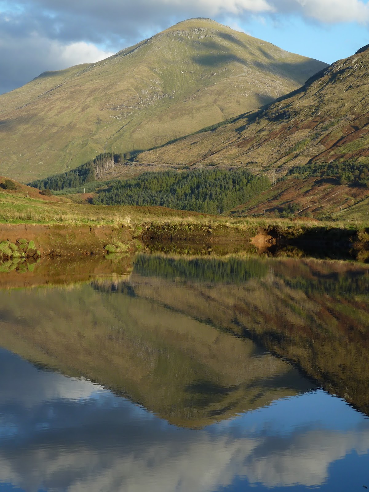
As the track wound higher, the views opened up and ahead Ben Vrackie, above Pitlochry, had a dusting of snow.


Eventually, after a long, meandering approach walk, the top of Deuchary Hill was in sight and the path skirted a high level lochan before making the final steep climb to the wee summit.


There was a wonderful surprise when we all pulled up onto the top as a stunning panorama of snow-covered hills was revealed on the northerly horizon.


Fact File
Start/finish: Dunkeld served by Glasgow/Edinburgh to Inverness trains.
Route: Walk north along the main street in Dunkeld then turn right up the A923. After 300m take the track signed to the left for the Glack and follow it to Mill Dam, a nice picnic and photo stop. The path up to Deuchay Hill leaves to the right just before Mill Dam and is signed as Upper Loch Ordie path. The path contours north round the hill through pleasant woodland with good open views. After 3.5km at Grid Ref NO024 492, a path crosses the route. Turn right uphill and follow the path to Lochan na Beinne. The top of Deuchary Hill is now in sight ahead. Continue on the path beside the Lochan and up the final steep section to the top. For a different and shorter route back, pick up a narrow path that heads southeast from the top. It's not obvious at the top itself but the start can be spotted just ahead. The path drops steeply then joins a bigger track. Turn right on the bigger track and follow it until it joins the outward route.

Saturday 12 November 2016

Glen Strathfarrar - Three seasons in three days

Tucked away north of the Great Glen and west of Inverness, Glen Strathfarrar is long, meandering valley that reaches deep into the hills. Along its length it does in equal measures farmland, woodland, pine forest, lake, river and high peaks. Its climax is the beguiling mountain of Sgurr na Lapaich, whose rocky, pointed nose rises above the lush greens of ancient Caledonian pine forest. The glen is best enjoyed by cycling in along the quiet, single track road which is closed to public traffic and setting up camp for a few nights to immerse yourself in its wildness.


And that’s exactly what I did. I spent three very different days up there in late October. On the first day the air was still and the sun shone like summer. I sweated up the steep slopes of Sgurr Fhuar-Thuill along an excellent stalkers’ path that eased the way. The path stays in the bowl of the coire the whole way so that you don’t get any views until you finally step onto the ridge. And what views. 


The air clarity was perfect and the mountainscape was crisp and clear. Layer after layer of hills stretched as far as the eye could see to Torridon and Coigach and north to the isolated peak of Ben Klibreck. The clear skies persisted and in the evening the stars above the tent looked like the proverbial scatter of diamonds on black velvet. Stags rutted close by through the dark hours.

The next day was winter. A freezing fog hung low in the glen coating everything in a numbing cold and a hoary frost. Even the bike and tent were ghostly white. The sun’s rays eventually chased away the fog but didn’t warm the day much. I clambered up the steep slopes of Sgurr na Lapaich. The head of Glen Strathfarrar is a relatively remote place and, like yesterday, I had the hill to myself. The summit rocks remained coated in thick frost and were blasted by an arctic wind. I put up a ptarmigan which was already mostly in its white plumage for winter and a red fox high on the hill.


On the third day, I stayed low and ambled through the autumn woods as the first gales of the season passed through and shook the trees. In the low-angled autumn light, the bracken-covered hillsides were copper-coloured and the silver birch shimmered gold against the cobalt sky. The rowans were mostly bare except for clusters of punchy red berries while the riverside alders denied it was autumn  and remained dark and green and leafy. Flocks of fieldfares flitted across the treetops and the light played across the hillsides, illuminating patches in turn.

Next day I was blown back down the glen by the persisting autumn winds. They shook the leaves from the roadside birch trees and sent me off in a shower of golden confetti.


Fact File
Start/finish: Beauly train station
Route: Most people don't start climbing these hills from Beauly but I cycled in from the train station there which possibly has the world's shortest platform. The back road over Fanellan Hill is a lovely way to go then the quiet road down Strathglass to Struy to start the cycle up Glen Strathfarrar. For Sgurr Fhuar-Thuill I took the track to the right of the road about 1.5km after Braulen Lodge. Higher up it becomes a super path for walking, passes above the lochan, contours around the coire and pops out on the ridge a little west of the top. I used the same way back down. For Sgurr na Lapaich, I continued over the two dams at the head of the glen to the end of the tarmac, crossed the river by a bridge at the mini hydro plant and picked a steep way up through the birch trees to Carn na Saile Leithe. From there it's a long haul up the northeast ridge but there are views all the way. The last section is really nice. I went down the same way. 

Monday 7 November 2016

Glen Falloch - 150 plus

At this time of year there can be days of exceptional beauty in the Scottish hills with crisp clear air and a soft autumn light that picks out contours and ridgelines. I hit it lucky with a couple of days just like that in the hills at the top end of Loch Lomond.

The two-day trip started at Inverarnan with the bus putting me out at the famous Drovers Inn. Situated at the north end of Loch Lomond, for over 300 years it's hosted cattle drovers, travellers and famous guests such as Rob Roy. It claims to have numerous ghosts such as the little girl in a pink dress that mysteriously appeared in a family photo that had been taken on a mobile phone in the hotel. Enquiries by the hotel had confirmed that no children were staying on that night.

Close to the Inn a path climbs up steeply beside the Beinglas falls. Below the falls, the bonnie banks of Loch Lomond were showing the first hints of autumn colour and alongside the waterfalls sparkled and created rainbows in early morning sunshine.

Above the falls, the route crossed boggy ground before climbing onto the ridge of Beinn Chabhair. It's a wonderful walk up here along a good path that twists and winds between rocky outcrops and opens up the view down the loch, its waters thick and silvery like mercury. The Crianlarich hills close in nearby but the mountain panorama is dominated by the graceful lines of Ben Lui, the biggest peak in these parts. 

A walk that seemed longer on the ground than it looked it on the map, eventually had me on the top. Beinn Chabhair is 933 metres high, it means Hill of the Hawk and it's my 150th Munro. After celebrating that milestone with a Primula cheese sandwich, I dropped back down off the hill and picked up the northbound West Highland Way as it headed up Glen Falloch. 


Over the years I think I've walked most sections of the Way as useful links between bus stops and peaks or train stations and glens. One day, when I'm too ancient and stiff for slogging up hills, I might walk the whole lot in one. Then I'll look forward to being old and eccentric, and walking with an umbrella, and paying my campsite fees by counting out coppers from my coin purse.  

The Way is quite close to the main road through Glen Falloch but dense woods obscure the traffic from view and the gush of the river through gorges or its gentle murmur over stones mostly masks the sound. I pitched the tent by the river and watched the sinking sun paint the peaks pink.


Next morning my camp spot was engulfed by a low-level freezing mist that had laid the first frost of the season. Somewhere above the mist was my next peak, An Castiel, the Castle. The West Highland Way took me a little bit further north before I struck upwards across rough slopes. A long, sweaty slog put me above the cloud and on the airy ridge of An Castiel, livened by a couple of interesting rocky sections. The sun shone but the top was scoured by a bitter wind so I didn't linger over the view of layer after layer of misty ridgeline. A bealach to the north of the top offered an easy route down and a long meander back alongside the river. The deer grass was starting to turn fiery orange and the occasional rowan added a blaze of scarlet. 


To save a plod along the main road in Sunday afternoon traffic, I hitched a lift into Crianlarich at the hillwalkers' car park. I had to share the back of a van with a damp spaniel. Mind you, at least the dog had taken a bath in the river at the end of its walk. I, on the other hand, had not which was possibly why I was consigned to the back.

Fact File
Start: Inverarnan by bus from Glasgow
Finish: Crianlarich for the bus back to Glasgow
Route: From the bus stop cross to the other side of the road and follow the footpath to the bridge/track that goes to the campsite in about 500m. Immediately after the bridge follow a sign and footpath to the right that skirts the campsite rather than going right through. When it comes round to the wee wooden cabins on the campsite, walk up the side of the last cabins to find a stile over the drystane dyke at the back. Follow the footpath all the way to Lochan Beinn Chabhair. As the path approaches the lochan, it swings to the left and uphill to join the ridge where it becomes much firmer. Follow it to the top. I retraced my steps as far as the top of the climb above the falls then took a path heading northwest which is now a track. It eventually drops down to join the West Highland Way. Next day I stayed on the West Highland Way until it crossed the A82 about 1km after Derrydarroch and continued up the road which has a wide verge here. About another 1.5km further on there is a large hillwalkers' carpark and at the north end there is a stile over the fence. The path here joins the track alongside the River Falloch. At a sheep fank, I left the track and climbed up grassy slopes to Sron Gharbh - a footpath forms higher up. Follow it along Twistin Hill which is a gorgeous walk, to the top of An Castiel. I continued southeast from the top and left the ridge at the bealach between An Castiel and Beinn a'Chroin, descending into Coire Earb and following the rover downstream. Back at the car park it's about a 2km walk into Crianlarich to catch a bus or train if you don't hitch a lift.