Wednesday, 9 September 2020

Angus - Glamping

Once a year my friend Graham and I make one outdoor trip where we stay in a campsite which, compared to wild camping, is our own take on glamping. We use Graham’s car for the trip so we are also able to take a table and chairs. As well as not having to dig a hole to go to the toilet, this is the ultimate in camping luxury. Our glamping trip this year was to a lovely campsite outside of Edzell in Angus.  

After two hours of travelling in the car, we were champing at the bit to get out on the bikes by the time we parked up in Edzell. A lovely farm road whisked us west through undulating fields before turning north to make an incredibly steep climb to the bealach between two hills. These were the White and Brown Caterthuns whose tops are the sites of ancient hill forts. We chained up the bikes and picked our way up the heathery slopes of White Caterthun. A pretty stand of larch trees diverted us so we had our picnic in their dappled shade before continuing to the top. 


As we crested the rise, what remains of the stone walls of the old fort lay in a loose circle around the top of the hill. I was surprised at the size of the place which covered all of the summit. It’s thought that the hill fort on White Caterthun was built by the Picts in the early years AD, while that on Brown Caterthun is older. The view from the top was panoramic as these little hills occupy a fairly isolated position. To the north, the southern Grampians started to muster some height and far to the south, we could see the silvery glimmer of the Firth of Tay. There was not a sound up there that day except the wind rustling the heather. It made it easier to close my eyes and try to imagine the past. After walking the extent of the fort, we returned to the bikes and plummeted down the other side of the hill. Another pleasant back road took us back to Edzell and onto our campsite. 


The campsite was centred around a large duck pond. There were lots of mature trees in the grounds and we set our table up under one of these, an old birch tree. In the evening we watched four bats flying back and forth above our tents, no doubt enjoying the last of the year’s midges. In the morning, it was the turn of the house martins to feast on the bugs and when they’d finished, they gathered on the overhead wires, looking like notes on a music sheet. 


On the middle day of our glamping trip, we made the long cycle from our campsite to the head of Glen Esk. A lovely road meandered into the hills which were a vibrant mix of russet bracken and the lingering hues of purple heather. The woods were still green though and the rowans heavy with postbox-red berries. 


Where the public road ended, we continued cycling along a gravel track that took us to a ruined chapel on the shores of Loch Lee. We wandered around the little cemetery trying to make out the dates on the old gravestones. Some we thought were 14th century. Then the stiff breeze that was throwing up white horses on the surface of the loch, sent us back down the glen with a welcome tailwind. 


Edzell and our lovely campsite sit on the River North Esk at a point where it runs through a beautiful gorge stuffed with lush woodland. This made for a nice afternoon walk into the village for coffee, though the latter part of the east side path became quite adventurous with some scrambling up and down tree roots. A further frisson of excitement was added to our walk when we passed two old gents who said of the bridge that we had to take back across the river “rather you than me”. The beech trees along this walk were stunning with leaves that were as vibrant a green as if they had just emerged in spring. The river was equally lovely. At times it was a thunderous torrent through deep chasms and at other times it was slow and peaceful, forming enticing pools. Graham didn’t agree with me when I said I wished we had brought our swimming wetsuits. 


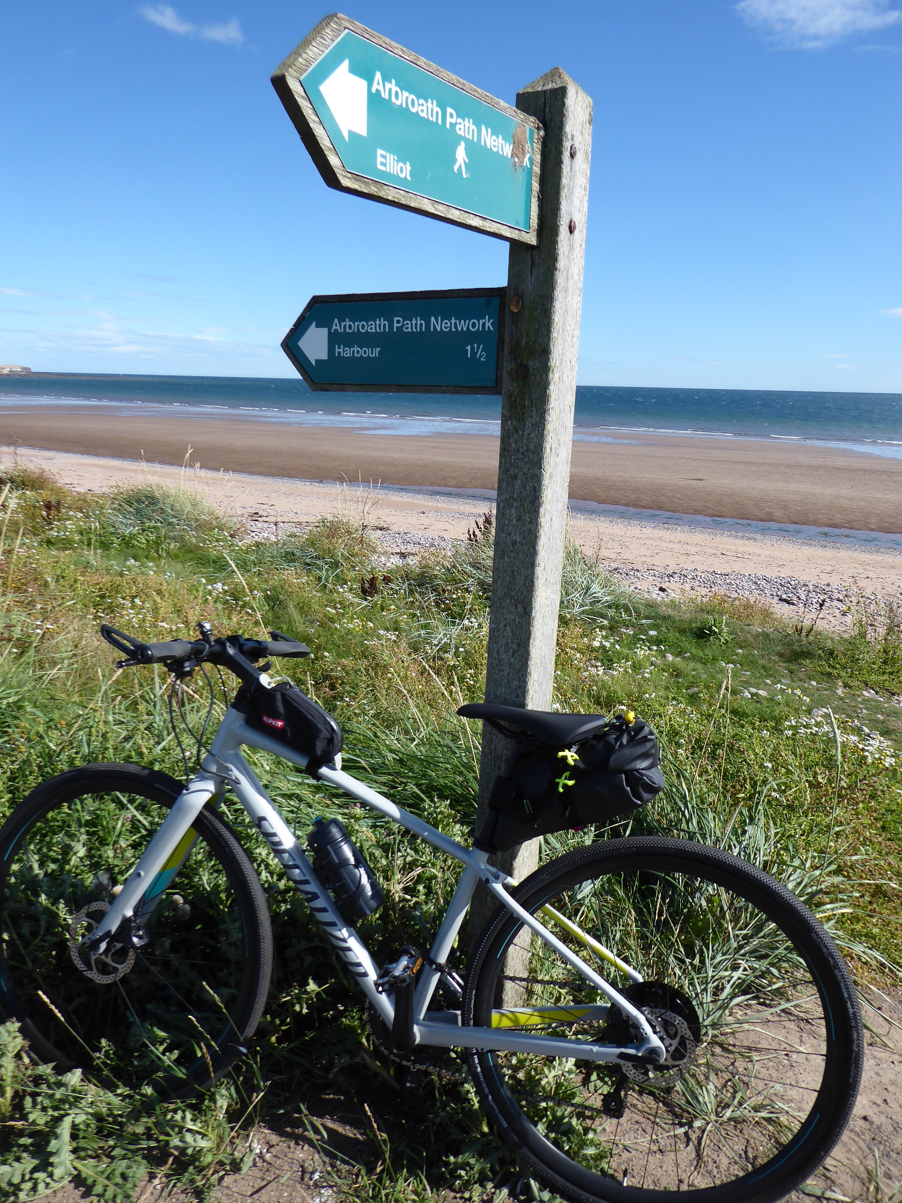
The nice thing about Angus is that its scenery is really quite varied. So for the last day of our glamping trip, we left the hills behind to head to the coast at Arbroath and enjoy the wonderful cycle path that runs along the links here. It wasn’t a long ride but it was lovely. The North Sea was sapphire blue today and so clear was the view that we could make out the Bell Rock lighthouse, eleven miles offshore. The path was lined by the last of the summer flowers – scabious, clover and yarrow – and ran along a strip of land between the beach and the railway line. 


It deposited us at the old harbour. It was a fine place to linger and watch the world go by before heading home.


Tuesday, 18 August 2020

Western Pentlands - The Covenanter's Grave

The sun was starting to sink above Bleak Law as we reached the spot, turning the harsh light of day into a softer, golden veil. All around us the moor was flushed with purple heather and hazy hills were layered to the horizon. Only Tinto stood out as a defined peak, reminding us how these western extremities of the Pentlands creep towards Lanarkshire. We were soaking up this view from the flank of Black Law hill, an isolated, barren place but for a single gravestone facing the evening sun. We'd walked a fair distance to get here, a spot I'd wanted to visit before lockdown put the hills out of bounds. The stone is the Covenanter’s Grave and its story is a poignant one.


In 1666, a small Covenanter army had risen in south-west Scotland and then advanced towards Edinburgh in an attempt to win support. On 28 November 1666 at the eastern end of the Pentland Hills, they clashed with a superior Government army in the Battle of Rullion Green. The Covenanters were defeated and those caught, were hanged. One Covenanter, his name unknown, escaped despite being mortally wounded. He headed westwards to try to make his way home to Ayrshire. He was suffering badly from his wounds when he knocked on the door of a shepherd called Adam Sanderson who lived near Black Law. At risk to his own life, the shepherd let him rest in his barn. Knowing he was seriously ill, the Covenanter asked that if the shepherd should find him dead in the morning, would he bury him in sight of the Ayrshire hills, the land of his childhood. Sure enough, the next morning, Adam Sanderson found him dead. The shepherd carried his body up Black Law and buried him on its western slope. Almost 400 years later, we stood by the grave that summer’s evening and looked west. We could indeed make out the Ayrshire hills in the distance.

Having lingered a while by the grave, we continued up the hill a little further to look for a camp spot. We soon found a perfect patch of grass amongst the heather and got our tents up. The long days of midsummer have passed now so the sun quickly dipped below Darlees Rig, though the evening stayed warm. It was wonderful to be out in the hills again after lockdown, enjoying the simple pleasures of nursing a mug of tea and wrapping up in a sleeping bag before drifting off to sleep.


Next morning, we unzipped the tents to a grey day with low cloud that soaked the tents despite there being no rain. After breakfast, we packed up and walked south, past the Covenanter’s Grave again then over Cairn Knowe. So villainous was the bog here that marker posts have been laid to help guide you across it. Nonetheless we jumped from tussock to tussock in lots of places to avoid the squelchy stuff.

As we drew close to Garvald, we were grateful to reach a firmer path that took us back towards West Linton. Given how well it was constructed and how it connected the settlements here, I guessed it was a route of some antiquity that had perhaps been used by generations of farmers and drovers. 


That sense of the past was heightened as we walked further through the glen where we saw the huge, stone cairns of ancient burial chambers. They reminded us that it’s not only the Covenanter who is spending eternity in these hills.


Fact File
Info: The inscription on the stone reads: "To the memory of a Covenanter who fought and was wounded at Rullion Green, 28 November 1666, and who died at Oaken Bush the day after the battle and was buried here by Adam Sanderson of Blackhill". 
The gravestone in place today on Black Law was erected in 1841. The original stone that marked the grave is now held in Dolphinton Parish Church, a few miles to the south.
Start/finish: West Linton
Public transport: Stagecoach Service 101 between Edinburgh and Dumfries serves West Linton.
Route: In West Linton headed up Medwyn Road towards the golf course. Turned left at the club house and followed this road across the golf course. Ignored any branches off this track and eventually it contoured westwards on the south side of Slipperfield Mount. After the track crosses Medwyn Water, there is a four-way signpost a little further on and the route to the Covenanter’s Grave gently ascends north to Black Law. The grave is below the ridge on the western side of the hill. To return to West Linton we followed the path marked on the map but barely discernible on the ground, that goes over Cairn Knowe towards Garvald. Where it eventually met a good track beside West Water, we turned left. Where the track met cottages at Ferniehaugh, we hung right then left to pass in front of the grand house. We turned right after the pond in front of the house to pick up the path that passes northeast between North Muir and Mendick Hill. It rejoined our outward route. 
More photos on Flickr.

Monday, 27 July 2020

East Coast - Lockdown release

With the coronavirus lockdown finally easing, I fancied a long bike ride to blow away the cobwebs. I wanted to assure myself as well that I hadn’t lost too much fitness from months of being less active. Family visits, strung along the east coast north of Edinburgh, provided a goal for what was an 80 mile plus ride. I travelled light with not even a camera so the photos here are from my phone.

I used National Cycle Route 1 to cycle away from my front door and north out of Edinburgh. For sure the highlight of this first section is crossing the old Forth Road Bridge. With the bridge now only being used by buses and timetables still reduced, it was wonderfully peaceful cycling over it. I’d left the house early to cross before the winds picked up. It’s incredibly exposed at its high point and a less than pleasant place to be when it’s windy.


From the other side of the bridge in Fife, the route then climbs for a long, long way. I cycled up through Inverkeithing and Dunfermline, eventually popping out on the north of town to climb even more into the Cleish Hills. Passing through the outskirts of the town, through modern housing schemes, had been dreary but the road up and over the Cleish Hills was superb. A skinny, little road with no traffic, crested the ridge to reveal views over the Lomond Hills and the big splodge of water that is Loch Leven. It then plummeted down to Kinross through Nivingston Crags, an extension of the Lomonds escarpment and a surprisingly dramatic spot.


Out of Kinross the route used a section of the Loch Leven Heritage Trail. It's a dirt track that encircles the loch and is one of my favourite places to cycle. I only stayed with it for a couple of miles though before leaving at Wester Balgeddie. Here I picked up a wonderful, single track road that sneaked behind the Lomonds to Strathmiglo. A bit of a dogleg then took me to Auchtermuchty. I wanted to pay a visit here to the beautiful sculpture that commemorates Jimmy Shand, the Scottish accordion player. I sat for a few minutes on the grass beside Jimmy for a rest and something to eat. The onward route involved another climb to get over the hills and to return to the coast at Newburgh.


The back road out of Muchty quickly spawns a tiny, unclassified road that skirts to the west of Ormiston Hill. The little hills here actually belong to the Ochils range, representing their easternmost extension. As I cycled over the high point, I could see the River Tay below and follow its course back into the southernmost Highlands. From here there was another dizzying drop to Newburgh. 


I might have thought that was all the hard work done but the coast road to Newport is a bit of a rollercoaster of a ride and the day was now hot and sweaty. Things flattened out however, by the time I reached my second bridge crossing of the day over the Tay.
 

The final stretch from here is another favourite place to ride. A seaside cycle path leaves Dundee through the port to head for Broughty Ferry.  In times gone by, I used to tell people that you need your passport to visit the Ferry! Until a couple of years ago, the cycle path used to pass within the port’s security so photo ID had to be shown to get through. 


The last time I cycled up the coast beyond the Ferry was at Christmas, well into the dark evening. The cycle path was covered with white frost that sparkled in my headlight. Between Monifieth and Carnoustie there are a lot less houses so the light pollution is diminished and that night the sky was twinkling with stars. But now in summer the verges were awash with flowers and the heat of the sun made the pine trees cast an aroma that reminded me of cycling in Portugal.  Arriving at the championship golf courses however, reminded me that I was actually in Carnoustie.


Sunday, 5 July 2020

Gear Review - Bikepacking lugagge

Bikepacking has probably been one of the main evolutions in cycling in the last few years. It is essentially off-road or mixed surface bicycle touring with minimal amounts of gear. Mind you, it’s exactly what I’ve been doing at the weekend for the last 25 years but this latest evolution is accompanied by some nifty new ways to carry stuff on your bike. The traditional luggage options were always panniers and a rack but bikepacking luggage attaches directly to the frame. This makes it lighter, more aerodynamic and better for nimble off-road handling. What I have found though is that different cycling situations still require different luggage solutions, from day rides to multi-day tours, and from summer to winter. So I thought I’d set out the luggage solutions I’ve been using for the last couple of years.

For a lightweight, short summer tour my set up is a seat pack, handlebar bag and a top tube bag. My seat pack for touring is the Ortlieb seat pack. It’s really robust and completely waterproof with a maximum capacity of 17 litres, though with its roll-up closure, you can use it at much smaller volumes as well. Like all seat packs it uses the saddle rails and seat post for attaching to the bike. It’s got a stiffened bottom which means the whole pack doesn’t crumple when you tighten the straps which could lead to it rubbing against the rear tire. I chose this pack because it needed the smallest amount of clearance above the rear tire - I have a very small framed bike so the space for a seat pack is pretty limited. The triangle of my frame is also too small for a frame bag that makes use of the bike's central triangle, so I wanted to get plenty of capacity in my seat pack. I’ve added an extra strap to ensure it stays pulled up right against the saddle, reducing the risk of it rubbing on the rear tire. When loaded up and with straps fully tightened, I find there is still a small gap between the underside of the rear of the saddle and the top of the bag. I try to squeeze something into this space such as a lock or extra stuffsack because I find filling that gap seems to make the whole bag more stable.  There are bungee cords on top of the bag that help make use of this space, reflective patches and loops for a rear light. The cost when I bought it was £120.


My handlebar bag is an Alpkit Airlok Dual 13 litre stuff sack which is pretty robust and waterproof. I find it works really well by feeding it through the brake and suspension cables then tightening the integrated straps over the handlebar. I know that some people use a special handlebar frame for holding a front bag but I’ve found it works just fine for me without this. Finally, my little top tube bag is also from Alpkit and I have two different sizes, depending on the trip. These are both cheap purchases, under £20 I think.


The seat pack holds my sleeping bag, cooking kit, spare clothes and food. I’ll often strap waterproofs or a bike lock to the top. I’ll stick in here as well my spare inner tube and some bike tools plus small towel and toiletries. In the handlebar bag I put my tent plus my bicycle pump and tire levers. My tent is a Terra Nova Laser Competition 1 so it squashes down really small. The tent poles fit inside the Alpkit bag, making it a width that fits between the brakes but only just. The poles can also fit in the Ortlieb seat pack along the bottom. My sleeping mat I put in its own waterproof stuffsack and fit under the straps of the Alpkit bag. These straps are also a handy place to fit a map. The top tube bag holds stuff that I want quick access to, usually my camera and my wallet for those bike ride café stops.


For day rides, I don’t nearly need to carry so much so I use the top tube bag with a much smaller Altura seat bag. I think it’s the Vortex bag though it looks like it has evolved since I bought mine. It cost £45 when I bought it. I had a lot of trouble with this bag. If I pulled the straps tight enough to hold it flush with my saddle to avoid rubbing, it crumpled in the middle because it doesn’t have any stiffening. This resulted in the rear tire rubbing anyway which left me with a hole as the bag is made of lightweight material. I repaired the hole then stiffened the bag along the bottom by inserting a small plastic mudguard. Like the Ortlieb bag, I added an extra strap and it now works perfectly. The extra strap also makes it easier to access the bag because it holds it in place when I open it - you have to undo the saddle straps for access and without the extra strap the whole lot slides down the seatpost. The bag holds bike tools, a tube, an extra layer, waterproofs and lunch.


On a longer trip or in the winter months, I’m carrying more stuff with a warmer sleeping bag, bulkier clothes and lots of extras. Therefore, for winter cycle touring I go for a hybrid approach using the same handlebar arrangement but coupling it with panniers which give a much greater capacity. I use the Tubus Airy titanium rack so it’s really light and the Ortlieb smaller front panniers in their lighter weight waterproof material. This works really well and gives space to carry more food on longer trips. I do find as well that the panniers require much less faffing than the seat pack which takes a bit of time to get everything to fit well. However they are heavier and don't half rattle on bumps.


Of course, much of this stuff has been languishing in the cupboard in recent months due to the coronavirus lockdown. However it looks like in another week or so longer bikepacking trips will be back on the cards.

Sunday, 21 June 2020

Edinburgh - The Queensferry ride

I finished the ride in my last blog by coming along the coast to the east of Portobello but another of my favourite lockdown cycles runs along the coast to the west of Portobello. It’s an out and back ride with the turnaround point being one of Scotland’s most iconic views. 

I start by cycling west along the prom here in Portobello so I prefer to do this ride early morning before it gets too busy. I pass through Leith and pick up the Water of Leith walkway for a short stretch before I turn off north to Five Ways junction. Here five different cycle paths meet but I stay north which takes me back to the coast at Trinity. Once I’m passed the warehouses and industrial sites of Granton, the views really open up as I cycle along Silverknowes Esplanade. I’m right beside the sea again and can see up ahead the Forth bridges. 


The esplanade ends at the old village of Cramond. There used to be a small ferry here to cross the River Almond where it empties into the Firth of Forth but these days, I have to cycle a little way upriver to the first bridge. 


On the other side, I’m cycling across Dalmeny Estate and pass into open countryside, so the character of the ride really changes here.


A network of gravel tracks meanders through the estate which is a lovely mix of rolling farmland, coast and broadleaf woodland. There are big views from the open sections of trail, back to the city, across the water and to the Pentland Hills to the south. Further on, the trail hugs the coast again where tall pines form a backdrop to stretches of sandy beach that invite you to get off the bike and sit for a while. Also here is Hound's Point, said to be haunted by the dog of Sir Richard Mowbray who died in the Crusades.


Part of the cycle route sweeps across the landscaped grounds of Dalmeny House, a grand country mansion and home of the Earls of Rosebery. It was completed in 1817 and is still partly a private home, as well as a visitor attraction and event location. In front of the house, manicured lawns sweep down to the sea and views stretch over the Firth of Forth to Fife.


At the western extremity of the estate I pop out of the woods and into South Queensferry right below the iconic Forth Rail Bridge.  Is there a more famous view in Scotland? You never grow out of the childish joy of watching the trains rattle back and forward across the bridge. Of course, every child in Scotland is tricked into thinking that the trains go up and down the sides of the diamonds! 


In normal times, I would likely continue a little way further to grab coffee and cake in South Queensferry but, as everything is closed in lockdown, this is my turnaround point and I cycle back home. 

Sunday, 24 May 2020

East Lothian - Tranent wagonway

Living on the Portobello side of Edinburgh, I’ve got rich pickings for cycling in lockdown just over the county line in East Lothian. One of the routes, which I also run and walk in normal times, is a wee tour based around Tranent. On the way round, there are some fascinating snippets of Scottish history and great views from the higher parts of the ride. I’d probably say it is my favourite local lockdown loop.

On the bike, my trip starts by cycling south out of Portobello and joining the River Esk walkway to Whitecraig. But if I’m walking or running in normal times, I take the bus to Wallyford. It puts me out at the last stop right beside the Miners’ Stone. The carved stone commemorates the 38 miners who died working in the town’s coal mines and depicts mining scenes. Plaques nearby list the names of the deceased miners with dates ranging from 1857 to 1929. The mine here operated from 1840 until 1972, eventually closing due to the adverse economics of the day.


Whether on foot or on the bike, it’s now a stiff climb up the steep, northerly slope of Falside Hill to the charming Fa’side Castle.  Sitting right on top of the hill, it has a commanding view over the Firth of Forth. The castle dates from 1189 when the monks of Newbattle Abbey to the south of Edinburgh granted land to the 1st Earl of Winchester. However, the earliest part of the present building was constructed by the Fawsydes in the 15th-century. The castle was burned by the English before the Battle of Pinkie Cleugh, which was fought nearby on 10 September 1547 and Mary, Queen of Scots stayed at Fa'side Castle the night before the Battle of Carberry Hill on 15 June 1567. It is said she left behind a chest containing her finest clothes - a black dress sewn with grains of jet, a crimson coat and cloak, and her gold and silver embroidered hat. I wonder if that chest was ever found when the castle was being extensively renovated to its present state in the 1980s.


Moving on from the castle, I’m now cycling on the skinny road that travels east along the ridge of Falside Hill. I love this high road because once the climb is done, it’s a wonderful flat ride along the top, usually with a tailwind. The view really opens up here. To the north, I can look over the Firth of Forth to Fife and its Lomond Hills; to the west I look back to Edinburgh with its own hills, the Pentlands; and on my right the Lammermuirs form the undulating, southern border of East Lothian. The top of Falside Hill is only 144m high but with nothing else crowding in, there’s a wonderful sense of space up here.


All too quickly, the high road drops down to Tranent. I like to detour into Tranent’s centre to visit another poignant memorial. The sculpture of Jackie Crookston commemorates those who died in the Massacre of Tranent on 29 August 1797. The day before the massacre, a proclamation had been drawn up by local people to object to the conscription of Scots into the British Militia. On 29 August, it was handed to Major Wight, the commanding officer of the recruitment squad. It was ignored initially until a contingent from the local colliery communities, led by Crookston, confronted the troops. Their response was brutal and several of the protesters, including Crookston, were shot dead.  Her larger than life sculpture looks over the main street and depicts her rallying fellow protesters.


I cycle back on myself a little now to pick up the next section of my ride which is hidden behind the houses and passes under the main road to descend through the woods. This is the disused route of the Tranent Wagonway. 


Running from Tranent to Cockenzie, the wagonway was opened in 1722. It was the first of its kind in Scotland and operated with wooden tracks and horse-drawn wagons. At two and a half miles long, it connected coal pits at Tranent with the harbour at Cockenzie on the East Lothian coast. Before the eighteenth century, salt production on the shore of the Firth of Forth was a significant activity and salt water was evaporated in salt pans. This required a lot of coal so when local deposits were used up, the wagonway was built to bring in coal from further away.


The Battle of Prestonpans in 1745 was fought across the wagonway and my cycling route today passes right beside the battlefield viewpoint and interpretation signs. Placed on top of a manmade mound, a bit like an Egyptian pyramid, it’s a stiff push to get up there with the bike. The battle was fought during the Jacobite uprising of 1745 when the forces of Bonnie Prince Charlie were advancing southwards, and the opposing forces of Sir John Cope brought them to battle. On 20 September 1745 Cope's troops and artillery ranged along the wagonway and used its embankment as cover. Nonetheless they were defeated by Bonnie Prince Charlie and sent packing. 


Further along, the wagonway is now a gravel track and passes right over the battlefield. There are two stone memorials, one for each army.


The wagonway is descending now to the harbour at Cockenzie, although the latter part of the line has been lost to the village’s expansion. I pop out of the woods and onto the road. Cockenzie was a centre for salt production itself but the harbour also provided a means to export the local coal by boat. The old harbour walls are made of large stones expertly placed together that always make me think of the big stone walls of Machu Picchu in Peru. With its colourful boats, the harbour still has some old world charm. It’s also a pleasant place to sit for a while, looking out over the sea.


Cockenzie is the last stop on my ride before I cycle home using a mixture of the coast road and gravel tracks.  By the time I arrive back at my front door, I’ve only cycled an 18-mile loop but I’m always amazed at how much I’ve seen along the way.

Fact File
Start/finish: Portobello, Edinburgh
Public transport if walking the route: Lothian Buses No. 44 drops you at the Miners' Stone in Wallyford. For the start, walk back on yourself to the first right, walk up past the industrial estate and continue on the path as it passes over the A1 and climbs the hill to pop out right beside the castle. Buses 26 or 124 return from Cockenzie to Portobello and Edinburgh.
My cycle route: Cycling south out of Portobello, I pick NCN1 at Brunstane and follow it to Whitecraig. Continue to the roundabout at the far end of the village and go straight over. Next right is the tough climb up Falside Hill. Follow this road towards Tranent and take the first road to the right into Tranent. Where this road junctions with another, turn right and the start of the wagonway is behind the Brig Inn. For the Massacre memorial, pass in front of the Brig Inn and where this road junctions with the main street in Tranent, turn right. Statue is on the right hand side of the street. Back to the wagonway, follow it downhill to the battlefield viewpoint which is clearly signed. Drop down the other side of the viewpoint, cross the pedestrian bridge over the railway line and turn right up this road. In a couple of hundred metres, the wagonway is signed to the left. Follow this gravel track and where it ends, join the road into Cockenzie. Where it junctions with the main coast road, go straight over for the harbour. 
Info: Fa'side Castle is currently for sale for £1.7m.
Monday, 11 May 2020

Edinburgh - Continental breakfast

I’ve cycled on the continent a few times now. I absolutely love it, whether it’s pootling through the pleasant countryside of France or whizzing along the excellent bike paths of Holland and Germany. I both started and finished my two-year, world bicycle journey on the continent and a couple of years later cycled for six months across northern Europe. There have been many highlights on these continental rides. One of them was a cycle tour within a cycle tour in the French Alps, as I was on the homeward leg of my world cycle. Over ten days or so, my friend Bart and I cycled fourteen of the French cols made famous by the Tour de France. One of the cols really stood out for me. It wasn’t the most beautiful which would be Galibier, or the highest which was Col de la Bonette, but it was a wonderful moment as we pulled up onto the top of this special col. Something about it captured the essence of my whole round-the world trip with a sense of triumph, joy and incredible freedom. It was Col de la Croix de Fer.


What a contrast life is just now with our freedom taken away by a global pandemic. Despite the lockdown, I wanted to do something that would at least give me a sense of joy. So I hatched a plan. My home city, Edinburgh, has an iconic hill as its centrepiece called Arthur’s Seat. This extinct volcano rises above Holyrood Palace and, despite its small size, affords great views in every direction. It’s guarded on the west by the tall, fortress-like cliffs of Salisbury Crags but on the east a steep road climbs up then contours round the hill’s upper flanks. The height gain is 90m. 


My plan was to cycle enough circuits of this high road on Arthur’s Seat to mimic the climb up Col de la Croix de Fer. That would be 17 circuits as although the col is 2067m in total height, the actual climb doesn’t start at sea level. I would cycle a few circuits before breakfast each day of the five-day working week and be ready to start work around my usual time. Once the plan was made, a perfect week to do it came around quickly with light winds and the last of the cold, crisp weather giving beautiful mornings in the city.


Every day my alarm went off at 4.30am. Every day I asked myself why this seemed like a good idea and every day I eventually got up out of bed. I pulled on my cycling clothes that I’d laid out the night before, grabbed thick gloves for the freezing morning temperatures and wheeled the bike outside the front door into the half dark that was neither night nor day. I cycled off into a deserted city and enjoyed the ride in the cool air along traffic-free roads. It’s a gentle rise from my house at the seaside to the bottom of Arthur’s Seat, so I was warmed up before the stiff climb.


Already the birds were singing their dawn chorus as I cycled the first section of the climb up through the trees which formed a green tunnel ahead of me. The trees gave way higher up to open ground and gorse scrub. By the time I reached the top of the climb for the first time each day, the shimmering, red globe of the sun was rising above the horizon between the Bass Rock and North Berwick Law. It was a stunning sight and the golden, dawn colours were reflected in the waters of the high loch, Dunsapie.


As my climb levelled out and I contoured round the hill my view changed. Far below me now was Duddingston Loch. On the coldest mornings, mist hung above the surface so that it looked like a primordial swamp and only the top of a few rooftops poked above it. Further away the Pentland Hills caught the morning sun and as I cycled further around the hill, the city rooftops were laid out below me. There was then a fast descent down to Holyrood Palace to start the climb again.


I cycled enough circuits Monday to Thursday to leave me just one circuit to do on the Friday. I cycled slowly for the last one and enjoyed the moment. I also made enough time when I finished to cycle a lap of honour around the Meadows, a large park a few minutes cycle away from Arthur’s Seat. Here I enjoyed the blossom trees and celebrated my climb up Col de la Croix de Fer.


The plan had started as something for a bit of fun but it was profoundly beautiful up there early morning, watching the sun rise in the quiet stillness of the breaking day. I would never have done it but for the lockdown and it’s an experience that will stay with me forever. If Col de la Croix de Fer symbolised the joy of my world cycle trip, then the dawn cycles around Arthur’s Seat will be my abiding memory of the pandemic.