
Glen Shiel is a narrow valley in the northwest Highlands that cuts a line through rugged mountains to drop to Scotland's west coast at Loch Duich, a long finger of sea reaching far into the hills. After rain, which is often, the steep hills and gullies weep water in hundreds of streams and waterfalls that coalesce into foaming white torrents in the lower glen. The north and south sides of the glen are bounded by high, narrow ridges that string together a mouth-watering array of Munros, Scottish mountains over 3000 feet. For some time I'd been wanting to do a circuit of the glen, walking out along one ridge, making a high camp in the mountains and then returning next day along the other ridge. A two-day window of good weather in an otherwise wet and windy holiday week with Bart provided the opportunity.
Day One - South Glen Shiel Ridge, seven Munros, 16 miles, 5971 feet of ascent

We set out early morning along the old Tomdoun road from the Cluanie Inn. It doesn't reach Tomdoun these days having been drowned by the hydroelectric schemes of Glen Garry. We eventually left the old road and picked up a wynding stalker's path that took us up onto the ridge and the first Munro of the day, Creag a Mhaim. A huge walk stretched out ahead of us through a jumble of peaks and a maze of ridges. There was a lot of lingering snow in the coires and gullies but the ridge itself was mostly clear. We headed west under grey skies, collecting more Munros with the passing miles. About halfway along, after the peak of Aonach Air Chrith, we came to the narrowest section of the ridge and picked our way carefully along the top of a thin fin of rock above sheer cliffs that plunged to the coire below.
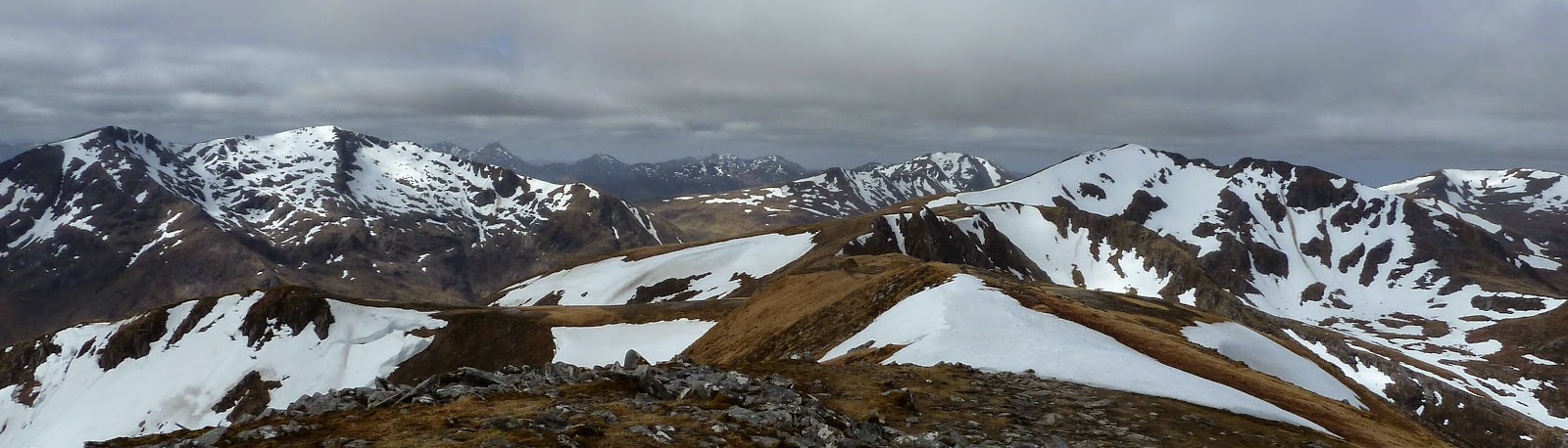
By late afternoon, the sun had finally broken through and the grey skies had cleared to blue as we clambered up the final Munro at the west end of the ridge, Creag nan Damh. It was the lowest peak of the day but the only one holding onto snow on the top itself. With seven Munros in the bag, we dropped off the ridge and followed a river downstream. It cascaded in a spectacular plume of water over tall cliffs and just below here we made our camp for the night. The sun dropped quickly behind the high peaks and it was soon cold. The temperature, or perhaps the day's exersions, forced us early into our sleeping bags.

Day Two - Brothers' Ridge, three Munros, 7 miles, 4450 feet of ascent
The second day of our mini adventure didn't get off to a perfect start when we got tangled up in steep forestry as we crossed the floor of the glen and then missed the route of a path up onto the ridge. The north side of Glen Shiel is precipitously steep and we found ourselves clambering up grass slopes where a dropped orange would have rolled all the way to the valley bottom. But once on the ridge, the day ahead was pure mountain joy in sunshine and blue skies with spectacular views of the neighbouring peaks, the Five Sisters of Kintail.

The route was again narrow in some places and the top of the second Munro, Sgurr a Bhealaich Dheirg, was strung out at the end of a skinny rock ridge that made a delightful airy stroll. The third Munro on the Brothers' Ridge, and the last of our trip, was a slightly disappointing lump of a peak but we sat there a while in warm sunshine until a chill wind chased us off the top. Back down in the glen, we found the faint line of the old military road that once ran through Glen Shiel, connecting Fort Augustus with barracks at Glenelg. It pleasantly covered the final miles back to our start point at Cluanie Inn where we had cold drinks sitting in the sun, content in the knowledge that we'd climbed ten new Munros.

Fact File
More photos - click HERE.
Start/finish - Cluanie Inn, Glen Shiel where the Fort William/Skye bus drops and picks up.
Map: OS Landranger 33
Route: Take the private road that heads south about 300m east of Cluanie Inn. Just as the road begins to drop to Glen Loyne a path leaves on the right. It soon splits - take the right hand split. This path zig-zags up to the first Munro on the ridge, Creag a Mhaim. The route west along the ridge is obvious in clear weather with a good path all the way. There are a couple of narrow sections on the ridge. For the second of these, as above, you need a bit of a head for heights although the exposure is minimal. After the last Munro on the ridge, Creag nan Damh, we returned to the bealach just before it and descended into Am Fraoch-choire, staying well on the east side of the river to avoid cliffs and then crossing easily at the bottom of the waterfall. From here there is a clear path and we camped a little further down beside the river. Next day we continued down the path. When it reaches forestry, it's better to walk on the east boundary of the forestry than to go through the middle. We then joined the main road in the glen, the A87, and walked east for 1.5km to a small layby on the north side where a path up to the north side ridge is signposted. At some point above the forestry we missed a faint split and ended up joining the ridge further west than planned. Once on the ridge, the route east across the Munros is again obvious with a good path. We came off our final Munro, Aonach Meadhoin, via its south ridge. Once down in the valley we picked up the old military road east of the forestry here which provided a good walking route back to the Cluanie Inn.
Tip: If camping is not your thing, you could do this route starting at the west end and stay at the Cluanie Inn overnight.
No comments:
Post a Comment