Few little hills that I know of pack the punch of the Garleton Hills in East Lothian. These small pimples above Athelstaneford have a wonderfully isolated situation such that the 360 degree views are superb. At least they were on a crisp, clear February day when I jumped off the North Berwick train at Drem to tackle the hills. They were the last hills that I hadn’t climbed that I can see on my local horizon from Portobello.

The folding bike transported me from Drem to Athelstaneford along a pleasant network of paths and farm tracks. They rose gently to the wooded ridge of Kilduff Hill before dropping down again into the village. Athelstaneford is the birthplace of the Scottish flag, the Saltire. The story goes that on the morning of a battle between the Scots and the English in 832AD, the Scots saw a white cross formed by clouds in the sky. Winning the battle, the Scottish forces attributed their victory to the blessing of Saint Andrew, adopted Saint Andrew's cross as their flag, and named him their patron saint.


A footpath sneaked out the far side of the village and crossed a field before dropping to the pretty gorge of the Cogtail Burn. Morning light flooded the woods here and illuminated swathes of snowdrops. The path climbed again and it was beyond here that the views started to open up as a track ascended the spine of the hills beyond the farm at Barney Mains. Walking across the top here, there’s an incredible sense of openness, space and big skies. These hills are made of layered volcanic rock subsequently scoured by glaciers. The highest point is only 186m but the panorama took in the Lomond Hills across the Forth to the north, the Pentland Hills and Edinburgh to the west, the Lammermuirs to the south and to the east was North Berwick Law and the Bass Rock. I could even see the Isle of May.

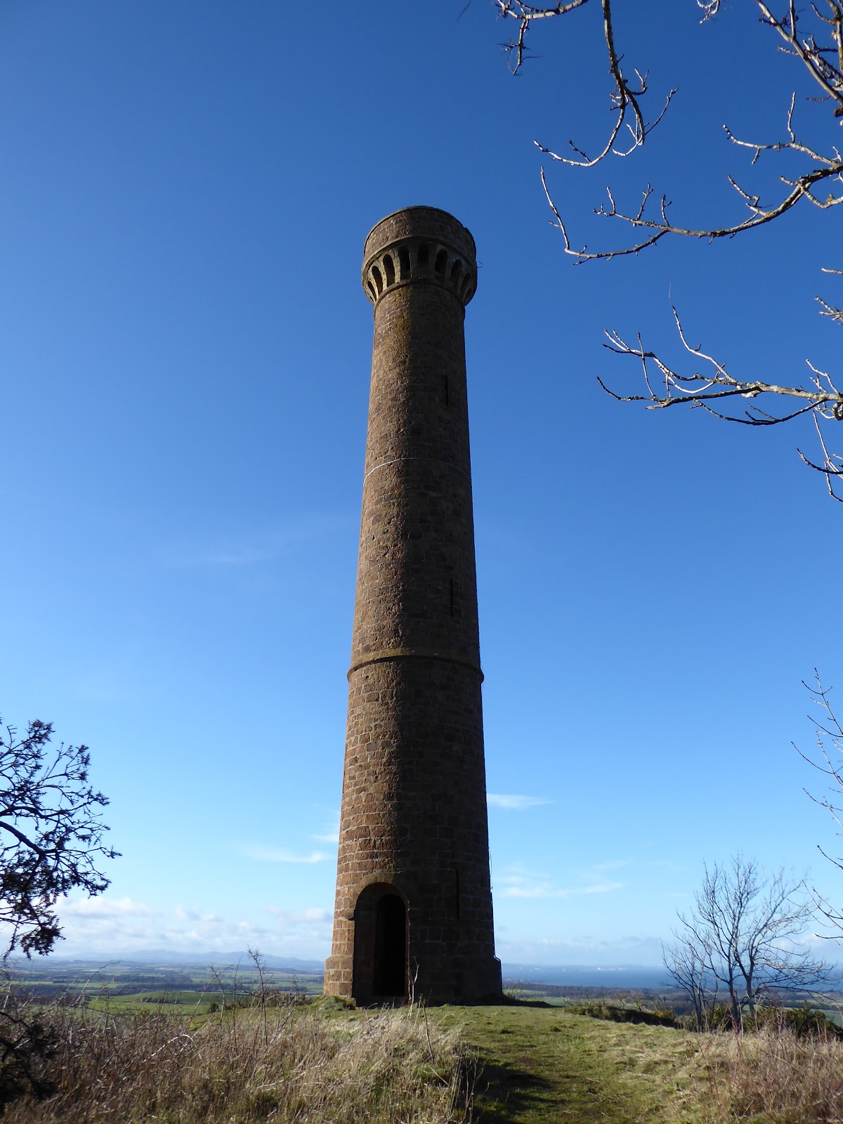
The most immediate view from here however is to the adjacent Byres Hill which hosts the impressive Hopetoun Monument. Returning to the village, I jumped back on the bike to cycle round there. Byres Hill was very different to Barney Mains. Its paths were wrapped up in a dense cloak of shady woods that stole the sense of space. But they were beautiful woods, dappled by sunshine, alive with birdsong and echoing with the shouts and giggles of children playing amongst the trees. A steep path that catches the breath pulled up through the trees to the base of the Monument. It was erected in 1824 in memory of John Hope, 4th Earl of Hopetoun, and is 29m high. If you bring a torch, you can go up inside.
Back on the bike, I pedalled hard to make the early afternoon train home so I had time before the early dark of February to sit on the prom and look east to the Garleton Hills. Finally I’d come to know those little pimples on the horizon and say “I’ve been there”.
Fact File
Public transport: Edinburgh to North Berwick train stops at Drem.
My route: Out of the station turned left then left again onto an unclassified back road which crosses the railway line. Where it crosses there is farm road straight ahead running south to Kilduff Hill. Kept left heading east when it reached the woods. 1km further on a junction is signed for Athelstaneford. Turned left when this path joined the road and cycled along the main street of the village. Up the east side of the school the path for the Garleton Hills is signed. Chained up the bike here. Path dropped to the Cogtail Burn and then climbed to join a farm track. Turned right on the track to the top of the hill, skirting the farm at Barney Mains to the left side and then picking up the track again. The route around the farm was signed and easy to follow. From Athelstaneford cycled west along the quiet B1343 and just before it joined the A6137, Byres Hill was signposted. Paths up the hill were obvious.
No comments:
Post a Comment