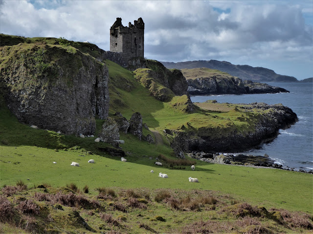
The castle was built around 1582 by Duncan MacDougall of Dunollie to control the trade through the Sound of Kerrera. In the sixteenth century it was one of the busiest shipping lanes in the region, offering easy access to the islands of the Inner Hebrides. The castle was originally a four storey tower with a small courtyard occupying the edge of the cliff. Although primarily built for defence, Gylen Castle also served as a status symbol and craftsmen were employed to create the Oriel window, much of which is intact today. The MacDougalls still owned the castle when the Wars of Three Kingdoms broke out in the mid-seventeenth century. The clan were supporters of the Royalist cause and in 1647 a detachment of Covenanters besieged the castle. The clansmen eventually surrendered and Gylen was sacked and burnt. It has remained a ruin ever since.
It was wonderful to linger here, taking in the history and natural beauty of the spot, but eventually I continued on my walk, rounding the south of the island and making my way up the west coast. The views from here to the hills of Morvern and Mull were stunning. I was envious of the people who lived in the isolated cottage at Barnabuck which sat in its own wooded bay on the coast with a view over all of this. I was less envious of them as I faced the steep climb from the cottage up and over the spine of the island.
This track took me back to the ferry slipway via Kerrera's main community at Balliemore. I was grateful I had some change for the honesty box at the craft hut here so I could have ice cream and a cold drink before the ferry back to the mainland. My walk had only been about 4 hours but there was so much variety and beauty packed into this small island.
Photos on FLICKR
Start/finish: Ferry slipway, Kerrera
Public transport: A local bus from Oban connects to some of the ferry times but it's less than 3km to walk there from the centre of town. A nice way to do the walk is over Pulpit Hill in Oban. Walk down from Pulpit Hill along Pulpit Drive and a little way along a footpath to the ferry is signed. It passes through a lovely wooded landscape above the coast.
My route: Turned left off the ferry and followed this main track south to the house at Lower Gylen, ignoring any side tracks on the way. From Lower Gylen, a grassy path heads down to the castle. Returned to the main track and continued west to the house at Ardmore. Here a path ascends to the left of the house and continues north to Barnabuck. Skirt to the front of the house then the track climbs steeply above the cottage and returns to the east coast of the island at the ferry slipway.


No comments:
Post a Comment